| | Thumbnail | | Creator | Date | Title / Author / Date / Location | Price | | | Description |
| 972 | 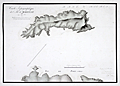 | Details | Pinot, Charles | 1816 |
| Antique manuscript map of Bagueau and Port-Cros in France's îles d'Hyères |
|
Pinot, Charles |
|
| 1816 |
| LOC:0 |
| $900.00 | Pinot--Charles | Antique-manuscript-map-of-Bagueau-and-Port-Cros-in-France-s-îles-d-Hyères | One of a kind, 200 year-old manuscript topographic map of the French Mediterranean island Île de Bagueau and the north coast of Port-Cros island. Signed and dated within by Ch[arles] Pinot, Director of Fortifications in 1816.
<br></br>
Topograhic detail shown through faint contour lines in pencil with benchmarks and elevation stated in several locations. Three cannon batteries noted in red on Bagueau. On Port-Cros, Pinot noted these features: Presqu'ile de Malalenge, Plage de Jeannet, Batterie Sud, and Chateau Ruine.
<br></br>
Both Île de Bagueau and Port-Cros belong to the îles d'Hyères, a group of four Mediterranean islands off the village of Hyères in the Var department of south-east France. Île de Bagueau at 45 hectares is the smallest of the four islands in the group. Port-Cros, at 650 hectares, is a French national Park.
<br></br>
Signed in French in faint ink: Toulon, 5th October, 1816 The Colonel and Director of Fortifcations Charles Pinot. A note in ink below the title begins: "La partie de terrain marquee…".
<br></br>
With a faint red oval overstamp of the "DEPOT de la Direction des Fortifications DE TOULON" |