| | Thumbnail | | Creator | Date | Title / Author / Date / Location | Price | | | Description |
| 5194 | 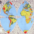 | Details | Pitner, L. E. | 1944 |
| Illustrated Octovue Map on Pitner's Projection |
|
Pitner, L. E. |
|
| 1944 |
| LOC:53 |
| $350.00 | Pitner--L--E- | Illustrated-Octovue-Map-on-Pitner-s-Projection | Rare and unusual world map on the Pitner projection. First edition. Illustrated with hundreds of small drawings of flora, fauna, native tribes, buildings, transportation and landmarks. With 5 inset maps on the Mercator and other more common projections. Card covers with map still attached.
<br></br>
The Illustrated World Octovue Projection Edited by Harold B. Ward Ph. D. F.R.G.S. Designed and Published by L.E. Pitner 229 W. Mineral Street, Milwaukee, Wis. Copyright November 3, 1944 by L.E. Pitner
The Octovue map was one of the few maps to use the Pitner map projection. The Pitner projection is explained as:
<div class="indenttextblocksingle">
"The globe is divided into eight uniform spherical triangular sections: four North and four South of the equator…. each transposed onto a flat surface. … the first map ever made to transpose the round world onto a flat sheet without distortion or exaggeration of shapes, sizes, and distances."
</div>
An earlier version of the Pitner projection map was published in 1943 on a single-sided sheet as the "Air Age Octovue Map of the World". Again edited by Ward with a 1943 copyright by Pitner. That version of the map lacks the illustrations and some of the map elements from the verso of our map are on the recto of the 1943 version.
<br></br>
The Pitner projection was similar to the Lambert Azimuthal Equal-area projection.
<br></br> |