| | Thumbnail | | Creator | Date | Title / Author / Date / Location | Price | | | Description |
| 5429 | 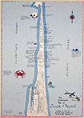 | Details | Price, Matthew | 1983 |
| Historical Map of Duck and Beyond |
|
Price, Matthew |
|
| 1983 |
| LOC:200 |
| $155.00 | Price--Matthew | Historical-Map-of-Duck-and-Beyond | Pictorial map of Currituck Sound, the Atlantic Ocean and the Outer Banks in the vicinity of Duck, Dare County, North Carolina. Created by Matthew Price in 1983.
<br></br>
This "Historical Map of Duck and Beyond" is decorated with scenes typical to the area near Duck, North Carolina (past and present): crabs, whales, wild flowers, shipwrecks, and ducks.
<br></br>
Price shows the street network and notes many points of interest on that narrow strip of land in the Outer Banks including:
<div class="indenttextblocksingle">
<ul style="list-style-type: circle;">
<li>Old Navy bombing range (no bombing allowed during hunting season).</li>
<li>Powder Ridge Gun Club</li>
<li>Caffey's inlet station</li>
<li>Maurice and Bea's Decoy Shops</li>
<li>Home and duck shop of "Pop" Scarborough</li>
<li>Ocean Beach campground</li>
<li>Duck Woods Golf Course</li>
<li>Old site of Martin's Point Club</li>
<li>Carolina Dunes</li>
</ul>
</div> |