| | Thumbnail | | Creator | Date | Title / Author / Date / Location | Price | | | Description |
| 258 | 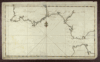 | Details | Randle, Charles | 1813 |
| Sold- Manuscript Chart - Portugal, Spain, Strait of Gibraltar |
|
Randle, Charles |
|
| 1813 |
| LOC:0 |
| $0.00 | Randle--Charles | Sold----Manuscript-Chart---Portugal--Spain--Strait-of-Gibraltar | This manuscript chart is sold.<br></br>
Small manuscript sea chart of Spain, Portugal and the Strait of Gibraltar. Signed and dated "C. Randle May 18, 1813". Despite the relatively small size of this manuscript chart, the author spent considerable time drawing fine detail of navigational hazards and features. The Guadalquivir River is shown past the bridge in Seville and the Guardiana River is shown to Alcoutin with some details that suggest the author was very familiar with its navigation. <br></br>
Charles Randle (fl. 1775 - 1813) served as an officer in the British Royal Navy during both the battle for American independence from Great Britain and
the war of 1812. Records show Randle held the rank of Lieutenant in 1783 and retired in 1820 with the rank of commander. <br></br>
Randle is best known for several watercolor drawings he produced during the time of the American Revolution. These include several drawings of the
battle of Valcour Island that show the British and American lines of battle . These and other drawings he made from that period are presumably based on his first-hand knowledge as a participant at those events. All are signed as C. Randle and are dated between 1775 and 1778.<br></br>
The Library of Congress records holding of 37 manuscript maps and 46 watercolor views signed C. Randle and dated to 1810 .<br></br> |