| | Thumbnail | | Creator | Date | Title / Author / Date / Location | Price | | | Description |
| 6832 | 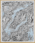 | Details | Rentola, Esko | 1947 |
| Pictorial map of the Hood Canal Area |
|
Rentola, Esko |
|
| 1947 |
| LOC: |
| $700.00 | Rentola--Esko | Pictorial-map-of-the-Hood-Canal-Area | Rare pictorial map of the Hood Canal Area in Washington State by artist Esko Rentola. Rentola was closely associated with the Quilette Indian tribe and this map reflects this attachment.
<br><br>
Other maps by Rentola produced between 1957 and 1964 include Camano Island (1957), Forks Washington and Vicinity, West End Washington, and Grayland, North Cove, Tokeland, all approximately 13.5" x 17" in size.
<br><br>
Rare. None of Esko Rentola's maps, including this one, are referenced in WorldCat and only no reference to this map is found online. Dated to 1957 by comparison to the Camano Island map (online) with a similar float-line border and address. |