| | Thumbnail | | Creator | Date | Title / Author / Date / Location | Price | | | Description |
| 6403 | 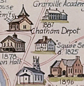 | Details | Rich, Howard L. | 1979 |
| Pictorial Historical Map of Chatham Massachusetts |
|
Rich, Howard L. |
|
| 1979 |
| LOC:87 |
| $225.00 | Rich--Howard-L- | Pictorial-Historical-Map-of-Chatham-Massachusetts | A fine original, first edition, pictorial historical map of Chatham, Massachusetts. Why buy a cheap copy when you can have the original version for a few dollars more?
<br></br>
The map shows numerous historical points of interest, those features no longer existing are shown in green font color. Includes an inset map of Monomoy Island and a smaller inset graphic representing the attack on Fort Fortune during October, 1606. Verso is blank.
<br></br>
Key geographical features on this historical map include Lookout Hill, Stage Harbor, Old Harbor, Great Beach, Strong Island, Great Hill, Morris Island, and Hardings Beach. Among the many historical events and locations that Rich chose to represent are the Mass. Humane Society hut for shipwrecked sailors, Old Harbor Life Saving Station, a ship's block factory, an Indian meeting house and burial ground, and the numerous salt works near Ryder's Cove.
<br></br>
Drawn by Howard L. Rich in 1979. Published by the Chatham Historical Society. |