| | Thumbnail | | Creator | Date | Title / Author / Date / Location | Price | | | Description |
| 3623 |  | Details | Ringgold, Cadwalader | 1850 |
| Antique Chart of the Entrance to San Francisco Bay |
|
Ringgold, Cadwalader |
|
| 1850 |
| LOC:63 |
| $1,100.00 | Ringgold--Cadwalader | Antique-Chart-of-the-Entrance-to-San-Francisco-Bay | Cadwalader Ringgold's detailed, chart of the approach and entrance at San Francisco Bay, California from 1850. Includes Yerba Buena island, Alcatraces (Alcatraz Island), Sausalito Bay, Aspinwall Bay, and much more. Attractive elevation profile view of a square rigged sailing vessel set against a backdrop of the coastline at San Francisco. Constructed, projected and drawn by Fred D. Stuart.
<br ></br>
Ringgold (1802-1867) was a officer in the U.S. Navy who had served aboard the brig Porpoise with the U.S. Exploring Expedition during Wilkes' surveys of the area in 1841 . Ringgold was promoted to Commander in July, 1849 and began his groundbreaking survey of the San Francisco Bay region, suddenly important because of the discovery of gold in the area. The survey began in August 1849, with Ringgold commanding the chartered brig Col. Fremont. Peter Guthorn notes Ringgold's use of Beechy's earlier survey in his charts:
<div class="indenttextblock">"Ringgold's charts and sailing directions employed material extracted from the account by Fredrick William Beechy, the British explorer and naval officer whose narrative of the voyage to the Pacific and Behring Sea was published in 1831." (Guthorn, Peter. "U.S. Coastal Charts 1783-1861." Schiffer Publishing. 1984. p. 195)</div> |
| 1097 | 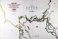 | Details | Ringgold, Cadwalader | 1851 |
| Antique U.S. Navy Chart of the Entrance to San Francisco Bay |
|
Ringgold, Cadwalader |
|
| 1851 |
| LOC:63 |
| $1,250.00 | Ringgold--Cadwalader | Antique-U-S--Navy-Chart-of-the-Entrance-to-San-Francisco-Bay | Cadwalader Ringgold's detailed, hand-colored chart of San Francisco Bay from 1851, extending up the Sacramento river at top right to Sacramento, Sutterville, and Boston, CA and to Stockton, Stanislaus City and San Joaquin at bottom right. Along Napa Creek Ringgold drew the plan of the small town of Vallejo which he refers to as "Capitol of the State". Other town plans include Suisun City, Martinez, New York, and Benicia. The map carries a dedication to William H. Aspinwall, Esq. of New York City, a merchant and ship owner.
<br ></br>
Published two years after the beginning of the 49'er gold rush, this most interesting lithographed chart is notable for the fine detail shown along California's rivers, which include names for a number of islands and regions which had never before appeared on commercial maps. The Webster or Russian Embarcadero is shown, as is Presidio, Washington, Indian Villages, Doaks Ferry, Martins, Table Hill, Petaluma Creek, Mount Diablo and many smaller islands, creeks, points and other features. Alcatraz island is labeled simply "Alcatraces".
<br ></br>
Ringgold (1802-1867) was a officer in the U.S. Navy who had served aboard the brig Porpoise with the U.S. Exploring Expedition during Wilkes' surveys of the area in 1841 . Ringgold was promoted to Commander in July, 1849 and began his groundbreaking survey of the San Francisco Bay region, suddenly important because of the discovery of gold in the area. The survey began in August 1849, with Ringgold commanding the chartered brig Col. Fremont. Of the sources used to compile the map Guthorn notes:
<div class="indenttextblock">"Ringgold's charts and sailing directions employed material extracted from the account by Fredrick William Beechy, the British explorer and naval officer whose narrative of the voyage to the Pacific and Behring Sea was published in 1831." (Guthorn, Peter. "U.S. Coastal Charts 1783-1861." Schiffer Publishing. 1984. p. 195)</div> |