| | Thumbnail | | Creator | Date | Title / Author / Date / Location | Price | | | Description |
| 6483 | 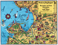 | Details | Sandefur, John Courtney | 1954 |
| Scarce pictorial cartograph or map Monterey Bay Hotel Jeffery |
|
Sandefur, John Courtney |
|
| 1954 |
| LOC:87 |
| $150.00 | Sandefur--John-Courtney | Scarce-pictorial-cartograph-or-map-Monterey-Bay-Hotel-Jeffery | Rare folding pictorial map of the Monterey Bay Region in California by John Courtney Sandefur. Sandefur's pictograms show the obvious influence of an earlier cartograph of the Monterey Region by Ruth Taylor White.
<br><br>
The map was published by Hotel Jeffery ca. early 1950s, then conducting business in Salinas, California for over 90 years. Colorful compass rose bearing a dog's image and the motto of the Hotel Jeffery- "Friendly."
<br><br>
Verso with text about the recreational activities and resources available in the Monterey Bay Area and the Salinas Valley including Pacific Grove, Carmel, Fort Ord, Santa Cruz, and Watsonville.
<br><br>
The Jeffery Hotel in Salinas, California was opened in 1888 at the corner of Alisal and Main Streets by William "Bill" Jeffery. In the 1970’s the original three-story Jeffery Hotel was demolished.<br><br>
<div id="0" align="center">
<a title="Hotel Jeffery, Salinas, California."></a>
<img id="3" src="/ZoomifyImages/SC_6483/SC_6483_HotelJeffery.jpg" alt="Photo of Hotel Jeffery, Salinas, California circa 1960" width="300"/> <br><small>Hotel Jeffery. <i>Courtesy U. California: https://calisphere.org/</i></small>
</div><br> |