| | Thumbnail | | Creator | Date | Title / Author / Date / Location | Price | | | Description |
| 567 | 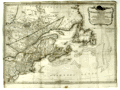 | Details | Sayer, Robert and Bennett, John | 1776 |
| A General Map of the Northern British Colonies in America |
|
Sayer, Robert and Bennett, John |
|
| 1776 |
| LOC:200 |
| $1,750.00 | Sayer--Robert-and-Bennett--John | A-General-Map-of-the-Northern-British-Colonies-in-America | Scarce antique map of the British colonies in North America during the Revolutionary War. Dated August 14, 1776. Coverage includes Maryland, Pennsylvania, New Jersey, New York, Massachusetts, Connecticut, New Hampshire, Maine, and the provinces of what is now Canada. Notes locations of American Indian tribes.
<br></br>
This map has been referred to as the "Beaver map" because of a prominent beaver in the title cartouche as well as some text related to a then unexplored portion of upstate New York: <div class="indenttextblock">"This vast tract of land which is the Antient Couchcachrage one of the four beaver hunting countries of the six nations is not yet surveyed."</div>
</br>
At very top is a second title: "The seat of war in the Northern Colonies containing the province of Quebec, Newfoundland, Nova-Scotia, New England, New York, New Jersey, Pennsylvania, etc.".
<br></br>
This map was originally one of six maps published by Sayer and Bennet in "The American Military Pocket Atlas; Being An Approved Collection of Correct Maps, Both General and Particular, of The British Colonies". David Rumsey notes that this is one of three maps in the atlas that were important to the mapping of the American Revolution. As Rumsey explains:<div class="indenttextblock"> "Nicknamed the 'Holster Atlas' because it was made for the use of British army officers. All maps in outline color, folded and bound into book with paper covered boards and quarter leather with "American Pocket Atlas" stamped in gilt on the spine."</div>
</br>
Watermarked with a shield containing a fleur de lis surmounted with a crown: at the bottom is "GR". Bottom attribution reads: London, Printed for Robert Sayer and John Bennett, Map and Seachart sellers No 53 Fleet Street, as the act directs, 14th Aug. 1776., |