| | Thumbnail | | Creator | Date | Title / Author / Date / Location | Price | | | Description |
| 6354 |  | Details | Smyth, William Henry | 1825 |
| Chart of the Grecian Shores Parga to Kaiapha with adjacent islands Gulf of Patras |
|
Smyth, William Henry |
|
| 1825 |
| LOC: |
| $350.00 | Smyth--William-Henry | Chart-of-the-Grecian-Shores-Parga-to-Kaiapha-with-adjacent-islands-Gulf-of-Patras | Rare chart of coastal Greece, Parga to Kaiapha by Captain W. H. Smyth and his assistant officers. 1825. |
| 5467 |  | Details | Smyth, William Henry | 1827 |
| Complete 4-sheet set of Sardinia Capt W H Smyth |
|
Smyth, William Henry |
|
| 1827 |
| LOC: |
| $6,000.00 | Smyth--William-Henry | Complete-4-sheet-set-of-Sardinia-Capt-W-H-Smyth | Exceedingly rare and complete set of four nautical charts of the Mediterranean island of Sardinia by Captain William Henry Smyth based on his hydrographic survey of Sardinia for the Royal Navy during 1823 and 1824. Sardinia is the second largest island in the Mediterranean and one of 20 regions of Italy.
<br></br>
Whatman Turkey Mill watermark (date illegible) on one of four sheets. Complete set of four, ea. ~ 17" x 24".
Elson and Graves are co-authors for all four charts. Slater is credited on the chart of the entire Island.
<br></br>
In 1828 Smyth published a book on the political history of Sardinia- <b>"Sketch of the present state of the Island of Sardinia"</b> [1]. Smyth references a four chart set in the introduction to his "Sketch": <div class="indenttextblocksingle">… in conclusion it may not be unnecessary to state that my <strong>Nautical Survey of Sardinia</strong> has just been published, on four sheets, at the Hydrographical office of the Admiralty. As no pains have been spared in the construction, it is hoped that these charts will be found equal to every purpose of Navigation. [Smyth's chart titles are used here:] </br><div class="indenttextblocksingle">
<ul style="list-style-type: circle;">
<li>A general chart of the Island, "The Island of Sardinia"</li>
<li>"The South Coast of Sardinia"</li>
<li>"The North East Coast of Sardinia"</li>
<li>"The Gulf of Asinara on the N. W. Coast of Sardinia"</li></div>
</ul>
</div>
Small traces of manuscript pencil notations attesting to real-life use of this chart while at sea. Well-executed early to mid 20th-century conservation with the chart laid to linen and protected via a thin-film lamination process. After experience with the lamination process over time, lamination is not now considered to be a effective document conservation procedure.
<br></br>
[1] Captain William Henry Smyth. London. John-Murray. 351 pp.
<br></br>
[Sardegna] |
| 5465 | 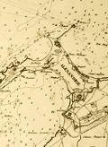 | Details | Smyth, William Henry | 1830 |
| Rare unrecorded chart of Alexandria Egypt after Smyth |
|
Smyth, William Henry |
|
| 1830 |
| LOC: |
| $250.00 | Smyth--William-Henry | Rare-unrecorded-chart-of-Alexandria-Egypt-after-Smyth | Unrecorded French nautical chart of the town, anchorages and environs around Alexandria, Egypt after a chart by Captain William Henry Smyth. Published by Bellue Libraire, Toulon, France in 1830. Lithographed by Moquin & Co., Montpellier.
<br></br>
Based on the survey of William Henry Smith R.N. (1788 - 1865) in 1822 aboard the surveying sloop Adventure, 6 guns.
<br></br>
Manuscript pencil notation and course tracks.
<br></br>
Mid-20th century conservation effort with the chart laid to linen and protected via thin-film lamination process to both recto and verso. |
| 784 | 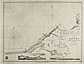 | Details | Smyth, William Henry | 1857 |
| The Coast of Egypt from Alamaid to the Rosetta Branch of the Nile |
|
Smyth, William Henry |
|
| 1857 |
| LOC:0 |
| $550.00 | Smyth--William-Henry | The-Coast-of-Egypt-from-Alamaid-to-the-Rosetta-Branch-of-the-Nile | Fascinating antique nautical chart of the Egyptian coast including Alexandria (Iskanderiah), Egypt, with its old port, and Aboukir Bay, the site of Admiral Horatio Nelson's decisive victory over the French fleet of Napoleon Bonaparte at the Battle of the Nile (Fr. Bataille d'Aboukir). At extreme right of the chart is one of the tributaries of the Nile River with the town of Rosetta ( Raschid ) and to the Northeast Fort Raschid now renamed Fort Julien. Fort Raschid is perhaps best known as the location where the stele known as the "Rosetta Stone" was discovered during a reconstruction in 1799.
<br></br>
This chart is a 1857 copperplate engraved edition of a nautical chart originally published in 1822 by W.H. Smyth of the British Royal Navy. This fine chart was made based on work conducted aboard the ship Adventure in 1821 as part of Smyth's survey of the North coast of Africa from the Strait of Gibraltar to the mouth of the Nile River.
<br></br>
With two inset coastal profiles: "Abukeer Castle from the Eastward", a pretty view of a felucca under full sail passing offshore Aboukir Castle (Taposiris Parva) and "Arab's Tower S.E. 10 miles".
<br></br>
With the oval logo of the British Hydrographical Office. Price when issued was 2 shillings. Number 242.
<br></br> |