| | Thumbnail | | Creator | Date | Title / Author / Date / Location | Price | | | Description |
| 2549 | 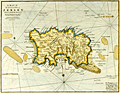 | Details | Stockdale, John | 1810 |
| A Map of the Island of Jersey in the English Channel. |
|
Stockdale, John |
|
| 1810 |
| LOC:88 |
| $0.00 | Stockdale--John | A-Map-of-the-Island-of-Jersey-in-the-English-Channel- | SOLD<br></br>
Early original copper-plate engraved map of Jersey Island one of the Channel Islands and a Crown dependency. Attractive antique engraved sheet.
<br></br>
The map was published by John Stockdale in London on the 26th of March 1805. This is a later printing ca. 1810 as demonstrated by the watermark "1809". Engraved by the prolific John Cary. |