| | Thumbnail | | Creator | Date | Title / Author / Date / Location | Price | | | Description |
| 5316 | 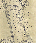 | Details | Stuart, C.W. | 1925 |
| Antique cadastral plat for Moundgrove Fruit Company Ormond Florida |
|
Stuart, C.W. |
|
| 1925 |
| LOC:87 |
| $0.00 | Stuart--C-W- | Antique-cadastral-plat-for-Moundgrove-Fruit-Company-Ormond-Florida | SOLD
<br></br>
Blueline plat map, with MS additions, of agricultural lands in Volusia County northwest t of Ormond Beach, Florida. The plat was created by surveyor C. W. Stuart during the 1920's Florida land boom.
<br></br>
The lands, in several tracts, were owned primarily by the Moundgrove Fruit Company and the Halifax Grove Company. From a lot of plats related to the Wetumpka Fruit Company. Shows Halifax Avenue at the west and John Anderson Highway spanning Moundgrove Fruit Company lands at bottom center. Other landholders include George Beed, H. T. Cook, W. R. McElroy; Raymond and Anita Tassinari.
<br></br>
Dated within at September, 1925. North oriented to the upper left corner.
<br></br>
With red ink stamp for the office of Alex D. Littlefield Realtor, 416 Seabreeze Blvd. Daytona Beach, Florida.
<br></br>
Lands shown on this plat are bounded to the west and south by Bulow Creek and to the east by the Intracoastal Waterway and Smith Creek. |