| | Thumbnail | | Creator | Date | Title / Author / Date / Location | Price | | | Description |
| 369 | 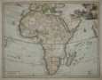 | Details | Tirion, Isaac | 1730 |
| Carta Generale Dell Africa |
|
Tirion, Isaac |
|
| 1730 |
| LOC:0 |
| $0.00 | Tirion--Isaac | Carta-Generale-Dell-Africa | SOLD- <BR> </BR>
Highly decorative map of the African continent with the Arabian peninsula, Turkey and Mediterranean. Coverage includes the Indian Ocean, Madagascar, and the Maldives to the east and to the west the Pacific Ocean islands as far as Brasil (Bresil). Decorative cartouche at upper right depicts men hunting a crocodile with elephant and ostrich in the foreground. |
| 109 | 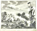 | Details | Tirion, Isaac | 1752 |
| Zes galeien overzeild en in den grond geshooten |
|
Tirion, Isaac |
|
| 1752 |
| LOC:1 |
| $200.00 | Tirion--Isaac | Zes-galeien-overzeild-en-in-den-grond-geshooten | Fine antique engraving by Isaac Tirion of an encounter between Dutch ships and eight Spanish galleys on October 3, 1602 in the English Channel off the coast of Dover. The galleys proved to be no match for the larger Dutch ships. In that battle three Spanish galleys were lost. |
| 2521 | 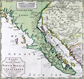 | Details | Tirion, Isaac | 1765 |
| Fine 18th century map of Lower California, Arizona and Mexico |
|
Tirion, Isaac |
|
| 1765 |
| LOC:10 |
| $750.00 | Tirion--Isaac | Fine-18th-century-map-of-Lower-California--Arizona-and-Mexico | Isaac Tirions's map of the American Southwest reflects the recent explorations of the Jesuit Fathers and others. Named locations include Casa Grande and San Xavier de Bac in the Southwest. Along the Pacific Ocean are noted San Diego, Ensenada and Cabo San Lucas. Numerous, oversized islands are shown along both coasts of the Baja California Peninsula.
<br></br>
Missions are pictorially identified throughout the map and there are two fortifications in Baja at San Jose del Cabo and Loretto.
<br></br>
Isaak Tirion, (1705 - 1765) was a Dutch publisher who produced several atlases and Dutch town plans from the Kalverstraat, in Amsterdam. Tirion produced a total of eight atlases in multiple editions |
| 1282 | 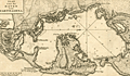 | Details | Tirion, Isaac | 1765 |
| Scarce antique plan or chart of Cartagena, Colombia |
|
Tirion, Isaac |
|
| 1765 |
| LOC:0 |
| $0.00 | Tirion--Isaac | Scarce-antique-plan-or-chart-of-Cartagena--Colombia | SOLD
<br></br>
Detailed antique harbor plan or chart of the bay and surrounding area near <b>Cartagena</b> (Carthagena) Columbia. At left of this fine map is shown the the small walled village of Carthagena. Most place names and features are in Spanish, including <b>Tierra Bomba</b>, Fort de Manzanillo, Castillo Grande, Fort de San Yago, Castillo de San Luiz, and near the village, Fort de San Felipe de Baraxas. The pass into the bay near the village of Cartagena was impassable even at that time as it is marked "Boca Cerrada".
<br></br>
The city, a major port, was founded in 1533, and named after Cartagena, Spain, which in turn was named after Carthage in Tunisia. Settlement in the region around Cartagena Bay by various indigenous people dates back to 4000 BC. During the Spanish colonial period Cartagena served a key role in administration and expansion of the Spanish empire.
<br></br>
Isaac Tirion (d. 1769) was an Amsterdam publisher. This plan of Cartagena, Colombia was published I Tirion's ' Nieuwe en beknopte handatlas' ca. 1765. |
| 1369 | 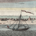 | Details | Tirion, Isaac | 1767 |
| Very early view of Pensacola, Florida from 1767 |
|
Tirion, Isaac |
|
| 1767 |
| LOC:11 |
| $260.00 | Tirion--Isaac | Very-early-view-of-Pensacola--Florida-from-1767 | Antique elevation view of Pensacola, Florida on the Florida Panhandle. This attractive engraved view documents the very few structures that existed in that Gulf of Mexico port 250 years ago just after the end of Spanish rule over the city. German text.
<br></br>
From the English-language edition of this view we learn the names of six objects or locations on the view: 1. The Fort. 2. The Church. 3. The Governor's House. 4. The Commandant's House. 5. A Well. 6. A Bungo. (A bungo was a type of boat or canoe used in the southern United States made of a hollowed-out tree.)
<br></br>
This engraving is the one of the earliest available printed views of Pensacola.
<br></br>
After Dominic Serres (1719-1793), a French-born painter primarily of nautical or maritime subjects. Serres was assigned to the Brtitish expedition to capture Havana, led by Admiral Sir George Pocock. It is possible that Serres visited Pensacola during that cruise. |
| 669 | 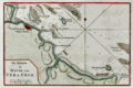 | Details | Tirion, Isaac | 1769 |
| Veracruz, Mexico |
|
Tirion, Isaac |
|
| 1769 |
| LOC:5 |
| $165.00 | Tirion--Isaac | Veracruz--Mexico | <br></br>Original antique chart of Veracruz, Mexico. Prominently features the walled city of Vera Cruz with the fortress (Kafteel) of San Juan de Ulua across a narrow channel. Includes Green Island ( Groen Eiland ) , White Island, Offerhanden Island, Blanquilla Island, Rivier Medello, Cape Gorda, Cape Hornos, Cape Mocamba, and Cape d'Anton Lizardo. Hydrographic features include numerous soundings and sandbanks.
<br></br>
It was on the island of San Juan de Ulúa that Spanish captain Juan de Grijalva first arrived in 1518, along with conquistador and author Bernal Díaz del Castillo ("The True History of the Conquest of New Spain"). That island was also the scene of a battle in 1569 between the Spanish Navy and a fleet led by John Hawkins that included Francis Drake. The treachery that the English perceived on the part of Spain at that battle helped to fuel antagonism between the two powers for many decades.
<br></br>
Published in 1769 from Amsterdam by Isaac Tirion (1705 - 1765) in his "Hedendaagsche Historie of Tegenwoordige Staat van Amerika" or "Modern History". |
| 659 | 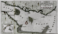 | Details | Tirion, Isaac | 1769 |
| Plate River, Buenos Aires and Montevideo |
|
Tirion, Isaac |
|
| 1769 |
| LOC:5 |
| $125.00 | Tirion--Isaac | Plate-River--Buenos-Aires-and-Montevideo | Original antique chart by Isaac Tirion of the mouth of the Plate River ( Rivier de la Plata ) and points in present-day Argentina and Uruguay, South America.
<br></br>
Noted features include the city of Buenos Aires ( Ayres) Argentina , Quilmes ( Quelmes ), Bay of Montevideo ( Montevideo ) Uruguay, Kruid Magazine, Wagthuis. Also includes the Juan River, St. Lucia River, Achuela River, Solis River, Baay van Maldonado, Kaap (Cape) St. Maria, Kaap der Steenrotsen, Kaap de Castilhos, and several islands: St. Michiel, St. Gabriel, Flora, and Zeehanden. Several large sand banks are shown. Inset map of the Bay of Maldonado.
<br></br>
Published in 1769 from Amsterdam by Isaac Tirion (1705 - 1765) in his "Hedendaagsche Historie of Tegenwoordige Staat van Amerika" or "Modern History". |
| 1069 | 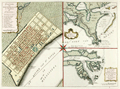 | Details | Tirion, Isaac | 1769 |
| Maps of French Colonial New Orleans and the Mississippi River |
|
Tirion, Isaac |
|
| 1769 |
| LOC:10 |
| $1,175.00 | Tirion--Isaac | Maps-of-French-Colonial-New-Orleans-and-the-Mississippi-River | Scarce early plan of New Orleans, Louisiana with insets of the mouth of the Mississippi River and also a long stretch of the Mississippi river from south of Donaldsonville to the passes. Published less than 50 years after the founding of New Orleans, Tirion's map of New Orlean's French Quarter is derived from an earlier map by Jacques Bellin / Brion de la Tour but contains additional details outside the French Quarter, which was largely marsh land at that time, including a road to Bayou St. John, a key trade route to the city from the east.
<br></br>
The sheet with three views is based on the layout of Thomas Jefferys earlier work (1759), who borrowed the earlier works of Jacques Bellin, of France's Depot de la Marine. Text is in German.
<br></br>
Isaak Tirion, (1705 - 1765) was a Dutch publisher who produced serveral atlases and Dutch town plans from the Kalverstraat, in Amsterdam. Tirion produced eight atlases in multiple editions |