| | Thumbnail | | Creator | Date | Title / Author / Date / Location | Price | | | Description |
| 857 | 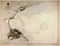 | Details | U.S. Navy Hydrographic Office | 1891 |
| Antique Nautical Chart of Yokohama Bay, Japan |
|
U.S. Navy Hydrographic Office |
|
| 1891 |
| LOC:59 |
| $0.00 | U-S--Navy-Hydrographic-Office | Antique-Nautical-Chart-of-Yokohama-Bay---Japan | SOLD<br><br>Antique nautical chart of Yokohama Bay, Japan produced by the U.S. Navy Hydrographic Office in 1891. Yokohama, a Japanese city south of Tokyo, in 1859 was one of the first Japanese ports opened to foreign trade.
<br></br>
Selected aids-to-navigation are highlighted in yellow including Hommoku Light Ship and two lights at the end of the harbor breakwater. Details ashore include a railroad line running along the shore, a public garden, a fort, the Grand Hotel, an area designated "foreign settlement", the French Hatoba (wharf or quay) , the English Hatoba, and the English Naval Store-house.
<br></br>
Detailed U.S. harbor charts of Japan, like this example are scarce during this time period less than 50 years after Commodore Matthew Perry's expedition to Japan in the mid 1850's. Contains the circular logo of the U.S. Navy Hydrographic Office. |
| 708 | 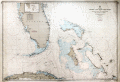 | Details | U.S. Navy Hydrographic Office | 1958 |
| Straits of Florida and Bahama Islands |
|
U.S. Navy Hydrographic Office |
|
| 1958 |
| LOC:0 |
| $0.00 | U-S--Navy-Hydrographic-Office | Straits-of-Florida-and-Bahama-Islands | SOLD
<br></br>
Decorative and colorful mid 20th-century U.S. naval chart of the southern Florida peninsula, cape Canaveral, Florida Keys, Marquesas Keys, northern Cuba, and Bahama Islands. Covers Miami, Biscayne Bay, West Palm Beach, and stretches as far north as Titusville Florida on the Atlantic coast. On the west Florida coast Cape Sable, Fort Meyers, and Tampa Bay. Other notable features covered by this old naval chart include Havana, Cuba; Crooked Island, Rum Cay, Long Island, San Salvador, Cat Island, Eleuthera, Andros Island, Great Abaco Island, and Grand Bahama Island.
<br></br>
The chart was printed during the cold-war period shortly after the Soviet Union launched its Sputnik satellite in 1957. In response to that perceived threat, during 1958 President Dwight Eisenhower signed the National Aeronautics and Space Act, which established NASA. Although Cape Canaveral became identified with NASA and best-known as the launch site for the U.S. space exploration program, the area had been used as a launch site for the early U.S. rocket program as far back as 1950 with the test of a V-2 rocket.
<br></br>
Because Cape Canaveral juts into the Atlantic Ocean and is in an area of swift currents it was the landing place for explorers and many shipwrecked mariners including the famous English privateer John Hawkins. Hawkins ship sank off Cape Canaveral in 1564. It is ironic that the same location that saw the end of many sailing voyages should be used as the launch site for a new mode of exploration many centuries later.
<br></br>
With the circular logo of the Department of the Navy Hydrographic Office. Bottom right in margin is a blue rubber-stamp ink impression stating that this sheet was corrected to August 2, 1958. Scale 1:875,960. Number 944. Price when issued $1.05. |