| | Thumbnail | | Creator | Date | Title / Author / Date / Location | Price | | | Description |
| 4847 | 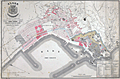 | Details | Vigouroux and Caillat | 1858 |
| Algiers, Algeria City Renewal Proposal 1858 |
|
Vigouroux and Caillat |
|
| 1858 |
| LOC:62 |
| $1,150.00 | Vigouroux-and-Caillat | Algiers--Algeria-City-Renewal-Proposal-1858 | Rock the Casbah!
<br></br>
Rare lithographed map of a proposed renovation and expansion project for Algiers in 1858. By Vigououx, surveyor and Caillat of France's Ponts and Chaussees (Bridges and Roads). At bottom left, the map is dedicated in manuscript ink, signed by the author (Caillat) to Colonel Marengo, then the Mayor of the commune of Douéra. Just a few years previously Marengo had been Commander of the Citadel of Algiers or the Casbah, and apparently still retained some influence. The citadelle or Casbah is shown marked near bottom right, but in a broader sense the Casbah was
<div class="indenttextblock">
"the ancient core of Algiers, the triangular-shaped town carved into the hills facing the Mediterranean … the sea forms the base of the triangle; a citadel is at the triangle's summit. (Celik, Zeeynep. Algiers under French Rule in "Urban Forms and Colonial Confrontations. University of California Press. 1997.) </div>
<br></br>
Shows the "rivage actuel" or the existing shoreline with the new construction that would occur to complete the project in those areas.
<br></br>
Background: the French invaded Algeria in 1830. In 1834, Algeria became a French military colony and was subsequently declared by the constitution of 1848 to be an integral part of France and divided into three departments: Alger, Oran and Constantine. |