| | Thumbnail | | Creator | Date | Title / Author / Date / Location | Price | | | Description |
| 2506 | 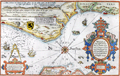 | Details | Waghenaer, Lucas Jansz | 1584 |
| Rare Dutch Sea chart of Belgium, Picardie, and France |
|
Waghenaer, Lucas Jansz |
|
| 1584 |
| LOC:9 |
| $1,800.00 | Waghenaer---Lucas-Jansz | Rare-Dutch-Sea-chart-of-Belgium--Picardie--and-France | A treasure! Chart of the English Channel printed in 1584, four years before the "Invincible Armada" of Spain was defeated in their attempt to conquer England. Extends from Nieuwpoort to Dieppe. With two coastal profiles. French text edition. Published in Leiden by Plantin. |
| 2572 | 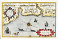 | Details | Waghenaer, Lucas Jansz | 1586 |
| Rare Dutch Sea Chart of The East Coast of England; Newcastle |
|
Waghenaer, Lucas Jansz |
|
| 1586 |
| LOC:9 |
| $2,400.00 | Waghenaer---Lucas-Jansz | Rare-Dutch-Sea-Chart-of-The-East-Coast-of-England;-Newcastle | Rare. Beautiful antique chart of the English North East Coast with the Tyne and Tees Rivers. This fine orginal Dutch chart was printed in 1586, two years before the "Invincible Armada" of Spain was defeated in Spain's attempt to conquer England. The chart is profusely decorated with sailing ships and sea monsters and beautifully engraved by Deutecum.
<br></br>
Includes the Tyne River with Tynemouth and Newcastle; the Tees River with Stockton; Hartlepool, and Sunderland.
<br></br>
With two coastal profiles. From the 1586 Latin edition of Wagenhaers Sphieghel der Zeevaerdt: "Speculum Nauticum". |