| | Thumbnail | | Creator | Date | Title / Author / Date / Location | Price | | | Description |
| 1275 | 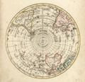 | Details | Walch, Johann | 1803 |
| Antique Southern Hemisphere polar view. |
|
Walch, Johann |
|
| 1803 |
| LOC:1 |
| $135.00 | Walch--Johann | Antique-Southern-Hemisphere-polar-view- | Attractive antique hand-colored <b>polar view</b> of the Southern Hemisphere. Perhaps most surprising about this copper-plate engraved polar map to modern eyes is the lack of an Antarctic Continent with its ice, which was not discovered by Europeans until much later. Published by Johann Walch, in his rare "Allgemeiner Atlas Nach den bewährsten Hülfsmitteln…", Augsburg, Germany, 1803.
<br></br>
Land details of this old map of the Southern Hemisphere include Van Dieman's Land (Tasmania), attached to Australia; Magellan's Land (Patagonia); Cook Strait in New Zealand; and Sandwich Land (not the Hawaiian Islands), discovered by Cook in 1775 and now the South Sandwich Islands. Notes the Amazon River, Congo, Madagascar, Paraguay, New Guinea, Java, and Borneo. |