| | Thumbnail | | Creator | Date | Title / Author / Date / Location | Price | | | Description |
| 1349 | 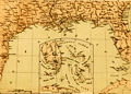 | Details | Wells and Smith | 1863 |
| Civil War era map of states bordering the Gulf of Mexico |
|
Wells and Smith |
|
| 1863 |
| LOC:0 |
| $0.00 | Wells-and-Smith | Civil-War-era-map-of-states-bordering-the-Gulf-of-Mexico | SOLD<br></br>Neat map from 1863 of the southern states bordering the Gulf of Mexico with Florida, Georgia, Mississippi, Alabama, and Texas. Numerous bays, rivers, and cities are identified including Charlotte Harbor, Key West, Indian River Inlet, Galveston, New Orleans, Madisonville, Pensacola, Tampa, Amelia Island, St. Simons Island, and Port Royal. Inset at bottom includes and extension for south Floria and the Keys.
<br></br>
Locations of key forts include: Fort St. Philip, Fort Barrancas, Fort Pike, Fort Pickens, Fort Morgan, Fort Dade, Fort Clinch, Fort Taylor, Fort Jefferson (Tortugas).
<br></br>
Publisher's attribution at bottom reads: "Entered according to act of Congress AD 1863 by Virtue Yorston & co. in the clerk's office of the district court of the United States for the Southrn. Dist. Of N. York." |