| | Thumbnail | | Creator | Date | Title / Author / Date / Location | Price | | | Description |
| 1477 |  | Details | Wilson, Charles | 1866 |
| Blueback Chart of the East Coast of England Dungeness to Newcastle |
|
Wilson, Charles |
|
| 1866 |
| LOC:0 |
| $900.00 | Wilson--Charles | Blueback-Chart-of-the-East-Coast-of-England-Dungeness-to-Newcastle | Eight feet long. Ninety-three inches of blueback sea chart covering the English east coast. Four sheets joined. Highlights of this huge blueback chart include dozens of yellow dots highlighting the lighthouses and the inset drawings of lighthouses and other navigational aids. More than one dozen inset port plans and river entrances, large scale. You need this in your man cave!
<BR> </BR>
With blue paper backing as issued. During the 1800's there was a trend toward publication of very large small-scale charts with large-scale insets of key passages and harbors. This made it possible for mariners to replace perhaps a half-dozen or more charts with just one. The practice was adopted as much for economics as any other reason. Charles Wilson (as the successor to Norie and Company) was one of a handful of British publishers who specialized in these charts which were often backed with canvas or linen cloth or heavy blue paper in order to help them withstand the frequent use and abuse aboard ship, hence the term "blueback chart".
<BR> </BR>
Published by: "Charles Wilson (Late J.W. Norrie and Wilson) at the Navigation Warehouse and Naval Academy, 157 Leadenhall Street." London.
<BR> </BR> |
| 522 | 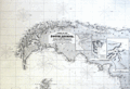 | Details | Wilson, Charles | 1877 |
| Blueback Chart of the East and West Coasts of South America |
|
Wilson, Charles |
|
| 1877 |
| LOC:1409 |
| $3,500.00 | Wilson--Charles | Blueback-Chart-of-the-East-and-West-Coasts-of-South-America | Very impressive, enormous, antique blueback sea chart of South America and west coast of the Antarctic Peninsula. We are unaware of any other copy of this chart. Strikingly large (6 ' +) and in excellent condition for 140+ years age. Oriented with North to the right. Drawn by J.S. Hobbs, F.R.G.S. Hydrographer. Insets of 'Magalhaen' Strait, Berkeley Sound and Stanley Harbor, Port of Valdivia, Rio Negro, Cumberland Bay, Port San Carlos, and Concepcion Bay. Numerous inset coastal profile views.
<BR> </BR>
Notable points of interest include Buenos Aires, Argentina, the Falkland Islands (Span. Islas Malvinas), Tierra del Fuego, Patagonia, Port Belgrano, Port Vallego, South Shetland Islands, and Graham Land (the western side of the Antarctic Peninsula named after Sir James R. G. Graham, First Lord of the Admiralty at the time of John Biscoe's exploration in 1832).
<BR> </BR>
With blue paper backing as issued. During the 1800's there was a trend toward publication of very large small-scale charts with large-scale insets of key passages and harbors. This made it possible for mariners to replace perhaps a half-dozen or more charts with just one. The practice was adopted as much for economics as any other reason. Charles Wilson (as the successor to Norie and Company) was one of a handful of British publishers who specialized in these charts which were often backed with canvas or linen cloth or heavy blue paper in order to help them withstand the frequent use and abuse aboard ship, hence the term "blueback chart".
<BR> </BR>
Published by: "Charles Wilson (Late J.W. Norrie and Wilson) at the Navigation Warehouse and Naval Academy, 157 Leadenhall Street." London.
<BR> </BR>
Seller's original red label reads: "River Plate to Valparaiso, including South Shetland Islands. C. Wilson (late Norie and Wilson), 157 Leadenhall St. London, E.C. Price 12 S, 0d." |