| | Thumbnail | | Creator | Date | Title / Author / Date / Location | Price | | | Description |
| 1459 | 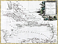 | Details | Zatta, Antonio | 1785 |
| French, English and Spanish Islands in the Caribbean Sea |
|
Zatta, Antonio |
|
| 1785 |
| LOC:10 |
| $425.00 | Zatta--Antonio | French--English-and-Spanish-Islands-in-the-Caribbean-Sea | Fine antique decorative map of the Caribbean Islands "Arcipelago delle Antille" with a beautiful and colorful title cartouche published from Venice, Italy. Shows Florida as an archipelago of islands. Antonio Zatta issued this attractive antique engraving in his "Atlante Novissimo" in 1785. |
| 3601 | 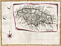 | Details | Zatta, Antonio | 1788 |
| Splendid antique map of Jamaica divided into parishes |
|
Zatta, Antonio |
|
| 1788 |
| LOC:10 |
| $400.00 | Zatta--Antonio | Splendid-antique-map-of-Jamaica-divided-into-parishes | Antique, hand-colored engraving, a decorative map of Jamaica drawn as though on a scroll, published in Antonio Zatta's 'Atlante Novissimo' as sheet IX in his twelve-sheet map of North America. With many engraved place names, rivers, mountains, etc. The island of Jamaica is divided into eighteen parishes including Portland, San Andrea, San Elisabet, and Westmoreland . Numerous place names, all in Italian.
<br></br>
Folio 9. Large compass rose. |