| | Thumbnail | | Creator | Date | Title / Author / Date / Location | Price | | | Description |
| 5171 | 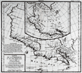 | Details | de Vaugondy, Robert | 1772 |
| Carte de La Californie et des Pays Nord Ouest 1772 |
|
de Vaugondy, Robert |
|
| 1772 |
| LOC:10 |
| $325.00 | de-Vaugondy--Robert | Carte-de-La-Californie-et-des-Pays-Nord-Ouest-1772 | Two maps of the West Coast of North America, from the Strait of Anian to Cabo San Lucas and the southern tip of Baja California in Mexico. The work by Vaugondy consists of comparative geography from two maps derived from Mercator (1612) and Petrus Planicus (1641). The larger map (by Mercator) shows the Strait of Anian, Anian Regnum, Quivira Regnum, the Sierra Nevada mountains, and Nova Albion. Includes over 30 coastal place names, including Cabo Mendocino, San Miguel (San Diego), Cape Fortuna, and Laguna de los Apostolos. On both maps the lower end of the Baja Peninsula, Cabo San Lucas is referred to as "Cabo California" but only on the larger map is northwestern Mexico called "Nova Granada".
<br></br>
The smaller inset map (by Planicus) also shows the Strait of Anian, and depicts an open sea above, suggesting a Northwest Passage in the Arctic Circle. The northwest coastline on North America differs radically, and only Anian Regnum and Quivira Regnum are located, the latter considerably south of the location on the larger map. The smaller map includes a similar number of coastal place names including Cabo Blanco , Cabo de San Francisco and los Farilones (the Farallon islands). |
| 1101 | 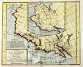 | Details | de Vaugondy, Robert | 1774 |
| Carte de La Californie et des Pays Nord Ouest |
|
de Vaugondy, Robert |
|
| 1774 |
| LOC:0 |
| $0.00 | de-Vaugondy--Robert | Carte-de-La-Californie-et-des-Pays-Nord-Ouest | SOLD, but we have an an additional uncolored similar engraving in stock by Vaugondy.
<br></br>
Two maps of the West Coast of North America, from the Strait of Anian to Cabo San Lucas and the southern tip of Baja California in Mexico. |