| | Thumbnail | | Creator | Date | Title / Author / Date / Location | Price | | | Description |
| 923 | 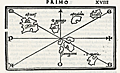 | Details | Bordone, Benedetto | 1534 |
| Very early map of Cadiz, Spain and the Azores, Portugal |
|
Bordone, Benedetto |
|
| 1534 |
| LOC:4 |
| $575.00 | Bordone--Benedetto | Very-early-map-of-Cadiz--Spain-and-the-Azores--Portugal | One of the earliest printed Azore Island maps (and another map of Cadiz, Spain) on a single sheet. Published from Venice in 1534 in the second edition of <b>Benedetto di Bordone's</b> nautical "Isolario", or Island Book.
<br></br>
The Isolario provided nautical-chart inspired maps of islands alongside information for travellers on their culture, myths, climate, and history.
<br></br>
A fine and original early nautical map of the <b>Azores islands</b>, in the Atlantic Ocean about 850 miles west of Portugal. Three islands on Bordonne's Azores map can be traced to their present-day equivalents: "S. Maria" (Santa Maria), "S. Georgio" (Sao Jorge), and "Samguimi" (Sao Miguel). Also shows the <b>mythical islands</b> of "Asmaida" and "Brasil" or Hy-Brazil as is is called in modern cartographic literature. Brasil island was long imagined to be located somewhere in the Atlantic Ocean to the west of Ireland. Brasil appears on several manuscript Portolani from the 14th and 15th century by Angelino Dulcert (1325), Andrea Bianco (1436) and others. Over almost 200 years several expeditions to find the Brasil were conducted by John Cabot, John Jay and others but as it was only an imaginary island the explorations failed.
<br></br>
Bordone's map of <b>Cadiz, Spain</b> (verso) is very interesting for its early place in the evolution of the cartography of that region. This map is almost cartoon-like in its simplicity. With the "Stretto de Gibilterra" defining the right limit of the map, and the "Regno de Castiglia" above, Cadiz is shown as a simple crescent shape slightly separated from the mainland. Towns that Bordone noted include "Gades" (Cadiz) , Turs, Tola, and S. Maria.
<br></br>
Bordone (1460-1531) was a Paduan cartographer, and an illustrator of manuscripts, best known for his 'Isolario' or book of islands. Bordone's work was only the second isolario ever printed, the first being that of Bartolommeo Dalli Sonneti published in 1485. Text in Italian. |
| 924 | 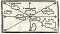 | Details | Bordone, Benedetto | 1534 |
| Very early map of the Leeward Islands of the Lesser Antilles |
|
Bordone, Benedetto |
|
| 1534 |
| LOC:5 |
| $940.00 | Bordone--Benedetto | Very-early-map-of-the-Leeward-Islands-of-the-Lesser-Antilles | The first printed maps of the Caribbean islands of St. Martin and Guadeloupe, published just 42 years after Christopher Columbus first landed in the New World. An attractive group of three antique maps inset on a single sheet with Italian text on verso and recto.
<br></br>
The recto includes a small-scale chart of the Leeward Islands. Here the geographical relationship of the islands bears little resemblance to present-day maps. Bordonne names the islands: "S. Maria Rotonda"; "Moserato" or Montserrat; "Buchima" or "Barbuda"; "Dominica"; S. Maria Antica" or Antigua; "Santa" or "Saint Kitts?; and "C. Martino" or St. Martin.
<br></br>
Two additional maps on the verso show the islands of "Guadalupe" Guadeloupe and "Matinina" or St. Martin. Each island is decorated with features that Bordonne addresses in the text. Guadeloupe is shown covered with a low leafy vegetation. St. Martin sports numerous caves set into small hills.
<br></br>
Published from Venice in 1534 in the second edition of Benedetto di Bordone's "Isolario", or Island Book. The Isolario provided nautical-chart inspired maps of islands alongside information for travellers on their culture, myths, climate, and history.
<br></br>
Bordone (1460-1531) was a Paduan cartographer, and an illustrator of manuscripts, best known for his 'Isolario' or book of islands. Bordone's work was only the second isolario ever printed, the first being that of Bartolommeo Dalli Sonneti published in 1485. Text in Italian. |
| 925 | 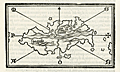 | Details | Bordone, Benedetto | 1534 |
| First printed map of the Caribbean island of Hispaniola |
|
Bordone, Benedetto |
|
| 1534 |
| LOC:5 |
| $900.00 | Bordone--Benedetto | First-printed-map-of-the-Caribbean-island-of-Hispaniola | The first printed large-scale map of the Caribbean island of <b>Hispaniola</b> which is shared by two nations: the Dominican Republic and Haiti. Also the first printed map to show the earliest settlement in the New World (other than a Viking settlement)- <b>La Isabela</b> ("Isabella"). During his second voyage in 1493 Christopher Columbus founded La Isabela on the central north coast of Hispaniola, in what is today the Dominican Republic. Map is inset onto a full page of Italian text.
<br></br>
This scarce antique map was published from Venice in 1534, just 42 years after Christopher Columbus first landed in the New World. From the second edition of Benedetto di Bordone's "Isolario di Benedetto Bordone Nel qual si ragiona di tutte l'Isole del mondo, con li lor nomi antichi & moderni, historie, favole, & modi del loro vivere, & in qual parte del mare stanno, & in qual parallelo & clima giaciono. Con la gionta del Monte del Oro novamente ritrovato". The Isolario provided nautical-chart inspired maps of islands alongside information for travellers on their culture, myths, climate, and history. Bordonne depicts the interior of the island as mountainous with numerous rivers flowing to the sea.
<br></br>
Bordone (1460-1531) was a Paduan cartographer, and an illustrator of manuscripts, best known for his 'Isolario' or book of islands. Bordone's work was only the second isolario ever printed, the first being that of Bartolommeo Dalli Sonneti published in 1485. Text on verso in Italian. |
| 926 | 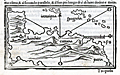 | Details | Bordone, Benedetto | 1534 |
| Early printed map of South America with Hispaniola and Jamaica |
|
Bordone, Benedetto |
|
| 1534 |
| LOC:5 |
| $800.00 | Bordone--Benedetto | Early-printed-map-of-South-America-with-Hispaniola-and-Jamaica | One of the earliest printed maps and the first obtainable map of the <b>South American continent</b>. South America is not recognizable as such but it closely compares to Rosselli's world map of 1508 from which Bordonne derived the shape.
<br></br>
Includes the Caribbean islands of <b>Jamaica</b> ("Iamaiqua") and <b>Hispaniola</b> ("Spagnola"). Within the truncated area of South America, Bordonne names four major regions which he discussed in the text: "Chanchite", (in the vicinity of present-day Colombia), "Cuztana", "Maziatombal" (associated with the Amazon River), and "Paria" (which may be related to the eastern portion of Venezuela).
<br></br>
This scarce antique map was published from Venice in 1534, just 42 years after Christopher Columbus first landed in the New World. From the second edition of Benedetto di Bordone's "Isolario di Benedetto Bordone Nel qual si ragiona di tutte l'Isole del mondo, con li lor nomi antichi & moderni, historie, favole, & modi del loro vivere, & in qual parte del mare stanno, & in qual parallelo & clima giaciono. Con la gionta del Monte del Oro novamente ritrovato". The Isolario provided nautical-chart inspired maps of islands alongside information for travellers on their culture, myths, climate, and history. Bordonne depicts the interior of the island as mountainous with numerous rivers flowing to the sea.
<br></br>
Bordone (1460-1531) was a Paduan cartographer, and an illustrator of manuscripts, best known for his 'Isolario' or book of islands. Bordone's work was only the second isolario ever printed, the first being that of Bartolommeo Dalli Sonneti published in 1485. Text on verso in Italian. |
| 927 | 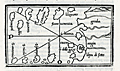 | Details | Bordone, Benedetto | 1534 |
| Early map of the Canary Islands and Cape Verde Islands |
|
Bordone, Benedetto |
|
| 1534 |
| LOC:7 |
| $950.00 | Bordone--Benedetto | Early-map-of-the-Canary-Islands-and-Cape-Verde-Islands | The first small-scale printed map to name the individual <b>Canary Islands</b> now part of Spain, and the Portugese <b>Cape Verde Islands</b>. Both groups of islands are shown in the Atlantic Ocean on a single map with part of Africa.
<br></br>
At right Bordonne shows the coast of Africa and names the on-shore regions "Getulia", "Argin" (Arguin ?), and "Libya di Sotto". Bordonne's names for the main Canary Islands and their modern equivalents are: "Palma" (La Palma), "Agore" (La Gomera), "Tinerif" (Tenerife), "Canaria" (Gran Canaria), "Forte Ventura" (Fuerteventura), and "Lazazoto" (Lazarote).
<br></br>
At bottom left are the most northern of the Cape Verde Islands, or the Ilhas de Barlavento:
"S. Antonio" ( Santo Antão),"S. Vincenzio" (São Vicente), "S. Jacopo" ("Santa Luzia"), "S. Nicolo" (São Nicolau). Some islands shown close to the coast are more difficult to account for: "I. Bianca" (Sal ?), "I. delle Gaze" (Boa Vista ?) and "Cuori".
<br></br>
From the second Zoppino edition of Benedetto di Bordone's "<b>Isolario di Benedetto Bordone</b> Nel qual si ragiona di tutte l'Isole del mondo, con li lor nomi antichi & moderni, historie, favole, & modi del loro vivere, & in qual parte del mare stanno, & in qual parallelo & clima giaciono. Con la gionta del Monte del Oro novamente ritrovato". This scarce antique map was published from Venice in 1534, just 42 years after Christopher Columbus first landed in the New World. The Isolario provided nautical-chart inspired maps of islands alongside information for travellers on their culture, myths, climate, and history.
<br></br>
Bordone (1460-1531) was a Paduan cartographer, and an illustrator of manuscripts, best known for his 'Isolario' or book of islands. Bordone's work was only the second isolario ever printed, the first being that of Bartolommeo Dalli Sonneti published in 1485. Text on verso in Italian. |
| 928 | 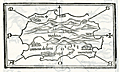 | Details | Bordone, Benedetto | 1534 |
| Early maps of Madeira and Ptolemaic Canary Islands |
|
Bordone, Benedetto |
|
| 1534 |
| LOC:7 |
| $950.00 | Bordone--Benedetto | Early-maps-of-Madeira-and-Ptolemaic-Canary-Islands | Two antique maps, one of Madeira, an island of Portugal in the Atlantic Ocean, and a curious map of the Atlantic islands on Africa's west coast based on the names and locations used by the Greeks and Romans. On the recto is the first printed map of the Portugese island of Madeira, by Benedetto Bordonne. Bordonne depicts the island as mountainous with numerous trees, and names four villages: "Camera de Lioni" (Câmara de Lobos); Fonzal" (Funchal); "Santa" (Sao Vincente); "Monerico" (Machico).
<br></br>
In his "Geography", Claudius Ptolemy, the Greco-Egyptian geographer lists a number of islands and their geographic coordinates. The verso contains one of the first printed maps showing the location of the Atlantic islands with Ptolemy's place names or that of the of the Roman geographer Pliny including: "Autolala" (Madeira), "Ninguaria" (Tenerife), "Canaria" (Gran Canaria), "Iunone" (Lanzarote or Fuerteventura), "Ombrio" (Ferro), and "Cisperia" (La Gomera). (Smith, William. <B>Dictionary of Greek and Roman Geography</b>. London. 1869. <a href="https://books.google.com/books?id=xgtAAQAAMAAJ&pg=PA906&lpg=PA906&dq=roman+names+for+canary+islands&source=bl&ots=2tZo3281lY&sig=rABlSnYBibeSpYSIR0SmvJp67Ms&hl=en&sa=X&ved=0CEMQ6AEwCDgKahUKEwjR28e1zerIAhXBJCYKHQ7VClc#v=onepage&q=906&f=false" target="_blank">Internet.)</a>
<br></br>
From the second Zoppino edition of Benedetto di Bordone's "<b>Isolario di Benedetto Bordone</b>" . This scarce antique map was published from Venice in 1534, just 42 years after Christopher Columbus first landed in the New World. The Isolario provided maps of islands alongside information for travellers on their culture, myths, climate, and history.
<br></br>
Bordone (1460-1531) was a Paduan cartographer, and an illustrator of manuscripts, best known for his 'Isolario' or book of islands. Bordone's work was only the second isolario ever printed, the first being that of Bartolommeo Dalli Sonneti published in 1485. |
| 929 | 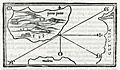 | Details | Bordone, Benedetto | 1534 |
| Early map of Porto Santo Island in the Madeira archipelago |
|
Bordone, Benedetto |
|
| 1534 |
| LOC:7 |
| $350.00 | Bordone--Benedetto | Early-map-of-Porto-Santo-Island-in-the-Madeira-archipelago | Antique woodcut printed map of Porto Santo off the west coast of Africa in the Atlantic ocean. One of the earliest printed maps solely devoted to Porto Santo island, in the Portugese Madeira island group. By Benedetto Bordonne, who shows Porto Santo, Portugal in its geographical context with Madeira to the south and the west coast of Africa or "Getulia" to the east. Show several villages scattered around the island.
<br></br>
On a full sheet of Italian text. From the second Zoppino edition of Benedetto di Bordone's "<b>Isolario di Benedetto Bordone</b>" . This scarce antique map was published from Venice in 1534, just 42 years after Christopher Columbus first landed in the New World. The Isolario provided maps of islands alongside information for travellers on their culture, myths, climate, and history.
<br></br>
Bordone (1460-1531) was a Paduan cartographer, and an illustrator of manuscripts, best known for his 'Isolario' or book of islands. Bordone's work was only the second isolario ever printed, the first being that of Bartolommeo Dalli Sonneti published in 1485. |
| 1037 | 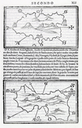 | Details | Bordone, Benedetto | 1534 |
| Early maps of the Greek Cycladic islands of Tinos and Andros |
|
Bordone, Benedetto |
|
| 1534 |
| LOC:2 |
| $0.00 | Bordone--Benedetto | Early-maps-of-the-Greek-Cycladic-islands-of-Tinos-and-Andros | SOLD<br><br>One of the earliest printed maps of the Greek islands of Tinos and Andros, both located in the northern Cyclades archipelago. Two maps on a single page. The map of Andros shows a fortified Andros town perched on a peninsula at the western side of the island.
<br></br>
Published from Venice in 1534 in the second edition of Benedetto di Bordone's 'Isolario', or "Island Book". The various editions of the Isolario were published using the same wood-block plates and each edition is differentiated from the other by the location of the page breaks within the text. The Isolario provided nautical-chart inspired maps of islands alongside information for travelers on their culture, myths, climate, and history.
<br></br>
Bordone (1460-1531) was a Paduan cartographer, and an illustrator of manuscripts, best known for his 'Isolario' or book of islands. Bordone's work was only the second isolario ever printed, the first being that of Bartolommeo Dalli Sonneti published in 1485. Text in Italian. |
| 906 | 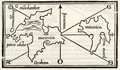 | Details | Bordone, Benedetto | 1534 |
| Very early Balearic Island charts with Ibiza and Majorca |
|
Bordone, Benedetto |
|
| 1534 |
| LOC:4 |
| $1,250.00 | Bordone--Benedetto | Very-early-Balearic-Island-charts-with-Ibiza-and-Majorca | Two of the earliest obtainable maps of Spain's Balearic Islands: Majorca / Mallorca, Minorca / Menorca, Ibiza / Eivissa, and Formentera. A single sheet containing two antique woodcut maps (one map on each side). Published from Venice in 1534 in the second edition of Benedetto di Bordone's 'Isolario', or "Island Book". The Isolario provided nautical-chart inspired maps of islands alongside information for travellers on their culture, myths, climate, and history.
<br></br>
Recto contains a map with a portion of the eastern coast of Spain, at that time part of the "Regno de Catelogna", with five un-named settlements near "C. Martino" (today a diving spot kown as Cabo de San Martin) that may include Gandia, Javea / Xàbia, or Alicante. Offshore of the coast are the Balearic islands of Ibiza ("Ieuiza") and Formentera ("Formentazia") with the smaller surrounding islets of Tagomago, "Famolaria" (Santa Eulalia ?), and "Dragoneza" in the vicinity of Illa Sa Conillera. The last may be a error on the part of Bordone as there is an island "Illa Sa Dragonera" but it is located off the coast of Mallorca in roughly the same relative location to the west of the island.
<br></br>
Verso contains a map with Majorca ("Maiorica") with "Porto Colobo" or the Bay of Palma, and Minorca ("Minorica") with " Porto Mao" or Port Mahon. Two islets shown are Illa de l'Aire ("Cabrera") and "Dragonera".
<br></br>
Bordone's directional symbols correspond to many of the Italian names for the principal Mediterranean winds including, [G]reco; a cross denoting East ; [S]irocco; [O]stro or South; [P]onente or West; and [M]aestro.
<br></br>
Bordone (1460-1531) was a Paduan cartographer, and an illustrator of manuscripts, best known for his 'Isolario' or book of islands. Bordone's work was only the second isolario ever printed, the first being that of Bartolommeo Dalli Sonneti published in 1485. Text in Italian. |
| 977 | 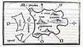 | Details | Bordone, Benedetto | 1534 |
| Very old wood-cut map of the island of Santorini, Greece |
|
Bordone, Benedetto |
|
| 1534 |
| LOC:2 |
| $600.00 | Bordone--Benedetto | Very-old-wood-cut-map-of-the-island-of-Santorini--Greece | An early map of the Greek Aegean Island of Santorini ("S. Erini") in the Cycladic Island group. Opposite the caldera from Thira is the smaller island of Thirasia ("Tiresia"). Shows four villages: Oia ("San Salvadore"), Pyrgos ("Scaro"), Akrotiri ("Acortiri") and "Apanomerca".
<br></br>
Shows a jagged set of lines on the west coast of the island similar to the letter "M" set on its side. From the location it almost certainly represents the switchback road leading down the cliff face to the beach and ferry station; a feature most tourists to the island who arrive by boat will well remember.
<br></br>
Map is inset onto a full page of Italian text. Verso contains another similar-sized map of the Cycladic island of "Namphio" (present-day Anafi) which lies just a few miles to the east of Santorini.
<br></br>
This scarce antique map was published from Venice in 1534, just 42 years after Christopher Columbus first landed in the New World. From the second edition of Benedetto di Bordone's "Isolario" which provided nautical-chart inspired maps of islands alongside information for travellers on their culture, myths, climate, and history.
<br></br>
Bordone (1460-1531) was a Paduan cartographer, and an illustrator of manuscripts, best known for his 'Isolario' or book of islands. Bordone's work was only the second isolario ever printed, the first being that of Bartolommeo Dalli Sonneti published in 1485. Text on verso in Italian. |
| 922 | 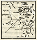 | Details | Bordone, Benedetto | 1534 |
| Very early chart of Lesbos or Lesvos, Greece |
|
Bordone, Benedetto |
|
| 1534 |
| LOC:2 |
| $375.00 | Bordone--Benedetto | Very-early-chart-of-Lesbos-or-Lesvos--Greece | One of the earliest printed maps of <b>Lesbos / Lesvos</b>, a Greek island in the northeastern Aegean Sea on a full page of text. Oriented with the east at the top, coverage includes Lesbos, and across the Edremit Gulf ("Colpho Adramatino"), the Ayvacik district of the Çanakkale Province of Turkey.
<br></br>
Perhaps the most interesting feature is that Bordone's map may be the earliest printed map to locate and name the Homeric <b>Bronze-age city of Troy</b>, although Bordone places Troy a bit farther south than its true location. On the mainland, in Turkey, near "Capo S. Maria" or present-day Babakale, the map shows a site "troia" with broken columns indicating ruins. Sonetti published an earlier map of Lesbos which inspired Bordone's map but there is no indication of ruins in that location, nor are there place names.
<br></br>
Shows the capital of <b>Mitilini / Mytilene ("Metelini")</b> somewhat misplaced to the northeast of the island. A bit to the west (on Bordonne's map) of Mitilini "la tore in mare" denotes a lighthouse in the sea. Nearby Mitilini, Bordone locates a hilltop church "Saint Theodoro". Saint Theodore is the patron saint of Mytilini.
<br></br>
Published from Venice in 1534 in the second edition of Benedetto di Bordone's 'Isolario', or "Island Book". The various editions of the Isolario were published using the same wood-block plates and each edition is differentiated from the other by the location of the page breaks within the text. The Isolario provided nautical-chart inspired maps of islands alongside information for travellers on their culture, myths, climate, and history.
<br></br>
Bordone (1460-1531) was a Paduan cartographer, and an illustrator of manuscripts, best known for his 'Isolario' or book of islands. Bordone's work was only the second isolario ever printed, the first being that of Bartolommeo Dalli Sonneti published in 1485. Text in Italian. |
| 978 | 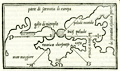 | Details | Bordone, Benedetto | 1534 |
| 16th century wood-cut map of Crimea and the Sea of Azov |
|
Bordone, Benedetto |
|
| 1534 |
| LOC:7 |
| $750.00 | Bordone--Benedetto | 16th-century-wood-cut-map-of-Crimea-and-the-Sea-of-Azov | Very scarce antique map of the <b>Crimean Peninsula</b> by Paduan cartographer Benedetto Bordone in 1534. Includes southern Ukraine labeled "parte di sarmatia di europa". With the Sea of Azov as "palude meotide" (<b>the Maeotis Swamp</b>) or "bicis palude". These names were applied in antiquity dating to Greek and Roman times.
<br></br>
The Strait of Kerch is labeled "bosphoro crinerico" and on the west side of Crimea "golfo di nigropila" is applied to Karkinitski or Karkinitsky Bay. An unnamed city is shown in the location held today by <b>Yalta</b>. The body of water we today call the Black Sea is labeled "mar maggiore" by Bordone.
<br></br>
This scarce antique map was published from Venice in 1534, just 42 years after Christopher Columbus first landed in the New World. From the second edition of Benedetto di Bordone's "Isolario" which provided nautical-chart inspired maps of islands alongside information for travellers on their culture, myths, climate, and history.
<br></br>
Bordone (1460-1531) was an illustrator of manuscripts, best known for his 'Isolario' or book of islands. Bordone's work was only the second isolario ever printed, the first being that of Bartolommeo Dalli Sonneti published in 1485. Text on verso in Italian. |