| | Thumbnail | | Creator | Date | Title / Author / Date / Location | Price | | | Description |
| 1416 | 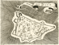 | Details | Coronelli, Vincenzo | 1686 |
| 17th century map of the Bohali fortress at Zakynthos, Greece |
|
Coronelli, Vincenzo |
|
| 1686 |
| LOC:2 |
| $160.00 | Coronelli--Vincenzo | 17th-century-map-of-the-Bohali-fortress-at-Zakynthos--Greece | Attractive 17th-century plan of the Venetian castle fortress on the island of Zakynthos or "Zante", Greece. Set atop a hill in the Bohali region of Zakynthos, the Bohali Castle is estimated to have been built in 1480 on the site of the ancient Acropolis. During the period of Venetian rule, the Castle was the capital of Zakynthos island, destroyed and repaired several times. In 1646 the walls were completed with help from the Venetians and their presence is apparent on the main outer gate where the wall bears the emblem of the famous Venetian 'Lion of St.Mark'.
<br></br>
Recent archaeological excavations at the Bohali Castle have found monuments from the Byzantine period, including a church dated to the 12th century.
<br></br>
This scarce wood-cut map was published by father Vincenzo Coronelli from Venice, Italy ca 1686 in "Memorie istoriografiche delli regni della Morea e Negroponte…".
<br></br>
Vincenzo Maria Coronelli (1650-1718) was an Italian Franciscan friar, cartographer, cosmographer and encyclopedist. Coronelli, a trained wood engraver, studied astronomy, Euclidean geometry and ancient philosophy and was named cosmographer for the Republic of Venice. He became most famous for his very large globes built in Paris from 1681-1683 at the order of King Louis XIV. His terrestrial and celestial globes measured 3.9 meters in diameter and were not equaled for more than 200 years. |
| 1255 | 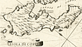 | Details | Coronelli, Vincenzo | 1686 |
| 17th century map of the Island of Corfu, Greece |
|
Coronelli, Vincenzo |
|
| 1686 |
| LOC:2 |
| $210.00 | Coronelli--Vincenzo | 17th-century-map-of-the-Island-of-Corfu--Greece | Fine antique map of the Greek island of Corfu which lies in the Ionian sea off Greece's northwest coast.
Key features on this attactive map of Corfu include the Canale di Corfu, the Fortezza (Fortress) di Corfu, and the villages of Agios Stefanos (s. Stefano), Scarpero (Skripero), Cauadales, Corissia (Lake Korission), and Neocon (Neochori).
<br></br>
This scarce wood-cut map was published by father Vincenzo Coronelli from Venice, Italy ca 1686 in "Memorie istoriografiche delli regni della Morea e Negroponte…".
<br></br>
Vincenzo Maria Coronelli (1650-1718) was an Italian Franciscan friar, cartographer, cosmographer and encyclopedist. Coronelli, a trained wood engraver, studied astronomy, Euclidean geometry and ancient philosophy and was named cosmographer for the Republic of Venice. He became most famous for his very large globes built in Paris from 1681-1683 at the order of King Louis XIV. His terrestrial and celestial globes measured 3.9 meters in diameter and were not equaled for more than 200 years. |
| 1256 | 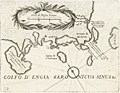 | Details | Coronelli, Vincenzo | 1686 |
| 17th century map of Saronic Islands and Athens, Greece |
|
Coronelli, Vincenzo |
|
| 1686 |
| LOC:2 |
| $230.00 | Coronelli--Vincenzo | 17th-century-map-of-Saronic-Islands-and-Athens--Greece | Attractive map from 1686 of the Attic region and islands of the Saronic Gulf in the neighborhood of Athens, Greece. Major islands shown include Kea, Salamina, Egina, Makronisos, and Patroklos (Patrocleia). Other features Coronelli deemed important were Porto Rafti and the Temple of Minerva. Athens is shown as "Atene" just to the north of a very shrunken Athenian Peninsula. In the vicinity of today's port of Pireas, Greece only a single tower "torre" is shown along with a depiction of dots and crosses in the water signifying rocks or other low-lying navigational hazard.
<br></br>
This scarce wood-cut map was published by father Vincenzo Coronelli from Venice, Italy ca 1686 in "Memorie istoriografiche delli regni della Morea e Negroponte…".
<br></br>
Vincenzo Maria Coronelli (1650-1718) was an Italian Franciscan friar, cartographer, cosmographer and encyclopedist. Coronelli, a trained wood engraver, studied astronomy, Euclidean geometry and ancient philosophy and was named cosmographer for the Republic of Venice. He became most famous for his very large globes built in Paris from 1681-1683 at the order of King Louis XIV. His terrestrial and celestial globes measured 3.9 meters in diameter and were not equaled for more than 200 years. |
| 4942 | 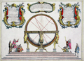 | Details | Coronelli, Vincenzo | 1689 |
| Globe Celeste |
|
Coronelli, Vincenzo |
|
| 1689 |
| LOC:62 |
| $650.00 | Coronelli--Vincenzo | Globe-Celeste | A copper-plate engraved view of the Globe Celeste of Vincenzo Maria Coronelli (1650-1718), considered as one of Italy's most famous and greatest cartographers. Coronelli was an Italian Franciscan friar, cartographer, cosmographer and encyclopedist, a trained wood engraver who studied astronomy, Euclidean geometry and ancient philosophy and was named cosmographer for the Republic of Venice.
<br></br>
Coronelli became most famous for his very large globes built in Paris from 1681-1683 at the order of King Louis XIV. His terrestrial and celestial globes measured 3.9 meters in diameter and were not equaled for more than 200 years.
<br></br>
The print, dated within at 1689, celebrates the consecration of the Celestial Globe in 1683 by Cardinal Destrees. Scarce. Only two sales recorded in the AMPR. |
| 5240 |  | Details | Coronelli, Vincenzo | 1689 |
| Primi Elementi o Introdutione al Corso Geografico |
|
Coronelli, Vincenzo |
|
| 1689 |
| LOC:62 |
| $650.00 | Coronelli--Vincenzo | Primi-Elementi-o-Introdutione-al-Corso-Geografico | An attractive, fine original copper-plate engraving that illustrates the basic principles of geography. The main map is a double hemisphere without landmasses, showing lines of latitude and longitude and climate zones The left sphere is inscribed with the names of the compass points and directions. The right sphere is inscribed with the names of the winds, and the is sphere divided into climatic zones.
<br></br>
The spheres are surrounded by several smaller spherical diagrams and tables making in all a very interesting and informative graphic compilation of the state of geographical knowledge in Venice, Italy at the end of the 17th century. From Coronelli's Atlante Veneto, based on work derived from his large globes.
<br></br>
Vincenzo Maria Coronelli (1650-1718) is considered as one of Italy's most famous and greatest cartographers. Coronelli was an Italian Franciscan friar, cartographer, cosmographer and encyclopedist, a trained wood engraver who studied astronomy, Euclidean geometry and ancient philosophy and was named cosmographer for the Republic of Venice.
<br></br>
Coronelli became most famous for his very large globes built in Paris from 1681-1683 at the order of King Louis XIV. His terrestrial and celestial globes measured 3.9 meters in diameter and were not equaled for more than 200 years. |
| 668 | 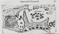 | Details | Coronelli, Vincenzo | 1690 |
| Cartagena, Colombia |
|
Coronelli, Vincenzo |
|
| 1690 |
| LOC:0 |
| | Coronelli--Vincenzo | Cartagena--Colombia | SOLD<br></br>
Colonial period map of Cartagena, Colombia or Cartagena de Indias from the Isolario or island book of Vincenzo Coronelli published from Venice in 1690. Original copperplate engraved chart on a half sheet. Number 157. Italian text on verso. |
| 96 | 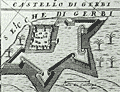 | Details | Coronelli, Vincenzo | 1691 |
| Isola e Castello di Gerbi |
|
Coronelli, Vincenzo |
|
| 1691 |
| LOC:8 |
| $325.00 | Coronelli--Vincenzo | Isola-e-Castello-di-Gerbi | A large antique sheet (13.5x19.5) from Coronelli's well known Isolario or Island Book with a map the island of Djerba off the north coast of Africa. With an inset of the Djerba Castle in upper right. <BR> </BR>
An interesting combination of styles, typefaces , and the broadsheet format makes this page by the famous Venetian cartographer a valuable addition to any collection at little cost. Copperplate engraving with Italian letterpress text below and on verso. Ornate capital letter "C". Page 301. |
| 97 |  | Details | Coronelli, Vincenzo | 1691 |
| Penon di Velez Isola della Goleta |
|
Coronelli, Vincenzo |
|
| 1691 |
| LOC:8 |
| $250.00 | Coronelli--Vincenzo | Penon-di-Velez-Isola-della-Goleta | A large antique sheet (13.5x19.5) from Coronelli's well known 'Isolario' or Island Book . Contains two engravings on opposing pages not backing on to the other. The engravings are nautical maps of two stronghold islands off the Moroccan and Tunisian coasts: Penon di Velez and Isola della Goleta. Italian letterpress text. |
| 820 |  | Details | Coronelli, Vincenzo | 1692 |
| Antique map of Cape Verde Islands and West Africa |
|
Coronelli, Vincenzo |
|
| 1692 |
| LOC:54 |
| $650.00 | Coronelli--Vincenzo | Antique-map-of-Cape-Verde-Islands-and-West-Africa | Beautiful antique map of the Cape Verde Islands and West coast of Africa by cartographer and Franciscan monk Vicenzo Coronelli (1650 - 1718). The map was published from Venice in 1692 in Coronelli's atlas, the Atlante Veneto. Highly decorative title cartouche at bottom left with angels holding a large tapestry in front of a decorative garland. Inset of the African island of Goree at upper right corner. Goree was a trading post with some association to the Atlantic slave trade.
<br></br>
The Cape Verde islands were a stopping and revictualing location for numerous early explorers since their discovery by the Portuguese around 1456. In 1522 the famished crew of Ferdinand Magellan's ship Victoria, numbering about two dozen, stopped at the island of Santiago on their return from their record-setting circumnavigation of the earth. A bit more that 60 years later in 1585, Sir Francis Drake attacked and burned the town of Cidade Velha on the island of Santiago.
<br></br>
Seller's attribution at bottom left reads "Si vende presso Domenico Padoani sul ponte di Rialto all'Insegna della Geografia." Contains some soundings and marked anchorages but the intended use of the map was not for navigation but for general information and decoration. |
| 894 |  | Details | Coronelli, Vincenzo | 1696 |
| Coronelli's globe gore of the Arabian Sea, India and Maldive Islands |
|
Coronelli, Vincenzo |
|
| 1696 |
| LOC:9 |
| $480.00 | Coronelli--Vincenzo | Coronelli-s-globe-gore-of-the-Arabian-Sea--India-and-Maldive-Islands | Unusual antique hand-colored <b>globe gore</b> by cartographer and Franciscan monk Vincenzo Coronelli (1650 - 1718). Originally produced for <b>Coronelli's 1688 terrestrial globe</b>. This fine engraved gore was included inset with text in his famous island book or "Isolario" published from Venice in 1696 - 1697.
<br></br>
Ranging from Oman, Dubai, and Abu Dhabi, past the Strait of Hormuz and then trending southeast across Iran, Pakistan and the west coast of India this scarce cartographic curiosity includes the Maldive Islands ("Isole Maldive" ) and west coast of Sri Lanka. Among the many noted towns and villages in India are Mumbai ("Bombaim"), <b>Hyderabad ("Golconda")</b> , and Madurai ("Madura").
<br></br>
A globe gore is a 2 dimensional representation on flat paper of a curved segment of the earth's surface. The gores are characterized by their curved top, bottom, and sides. Each gore would have been carefully cut to size and then pasted on a blank globe to produce a finished globe which would have been colored. Typically 12 gores were required to complete the 360 degree circumference of the earth at the latitudes covered by the gore.
<br></br>
We estimate a globe created with this gore would have had a circumference of about 11 feet. (The gore covers roughly 30 degrees of longitude or 1/12 of the earths circumference. At the equator, this gore is 11" wide giving us 11" x 12 = 132" circumference or 11 feet.)
<br></br>
Text on both the recto and verso is Italian. Page 113. |
| 752 | 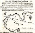 | Details | Coronelli, Vincenzo | 1697 |
| Antique chart of Cartagena Spain in Murcia by Coronelli |
|
Coronelli, Vincenzo |
|
| 1697 |
| LOC:8 |
| $325.00 | Coronelli--Vincenzo | Antique-chart-of-Cartagena-Spain-in-Murcia-by-Coronelli | Rare antique nautical chart of the harbor and anchorages near Cartagena, Spain in the region of Murcia. Simple, antique wood-cut print with profile view of the village of Cartagena, a compass rose, and soundings set in a much larger page of Italian text . Italian text also on verso largely consists of sailing directions ( distances and courses to steer between ports ).
<br></br>
Probably a copy by Coronelli derived from an atlas / pilot guide originally produced by the Genoan cartographer Francesco Maria Levanto in 1664 in "La Prima Parte dello Specchio del Mare…" . The Specchio del Mare was reissued later by Coronelli in 1697 and bears a strong similarity in paper, format, and typography to Coronelli's Isolario or Island Book. Charts from the Specchio del Mare are quite scarce and a small port plan such as this in text , even more scarce. Page 15. Chain laid paper. |
| 618 |  | Details | Coronelli, Vincenzo | 1697 |
| Chart of the Coast of Languedoc and Provence |
|
Coronelli, Vincenzo |
|
| 1697 |
| LOC:58 |
| $950.00 | Coronelli--Vincenzo | Chart-of-the-Coast-of-Languedoc-and-Provence | Antique nautical chart with original hand color covering the southern Mediterranean coast of France including the provinces of Languedoc and Provence. Coverage of this original antique chart includes numerous towns along southern France's Mediterranean coast, including the Cote d'Azure, Monaco, and the western coast of Corsica. Towns noted include Palamos, Roses, Agde, Marseilles, Toulon, Antibe, Freuil, and many more. From the scarce Isolario ( island book ) of Vincenzo Coronelli ca. 1697. <br></br>
Verso with Italian text on two pages and includes two inset views- the first of the town of Avignon, France along the Rhone river, titled "Avignone Già Seggio de Sommi Pontefici". The second inset view, titled "Isole di Ionquieres e Torre di Buc Nel Canale di Martegues" shows the area near the Canal de Martigues in the Bouches-du-Rhône department, nicknamed "The Venice of Provence" because of its canals and maritime features. |
| 3643 | 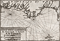 | Details | Coronelli, Vincenzo | 1702 |
| Coronelli's rare chart of England from Portland to the Lizard |
|
Coronelli, Vincenzo |
|
| 1702 |
| LOC:77 |
| $500.00 | Coronelli--Vincenzo | Coronelli-s-rare-chart-of-England-from-Portland-to-the-Lizard | Rare engraved chart from Coronelli's "Teatro della Guerra" shows the east coast of England (Provincia di West) from Portland Bill in Dorset to the Lizard in Cornwall. Features shown include Torbay, Dartmouth, the Isle of Wight and much more. A fine addition to any collection of coastal charts of England.
<br></br>
This small well-engraved antique chart is from the <b>Isole Britanniche</b> volume of the Teatro della Guerra. |
| 5210 | 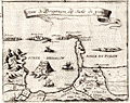 | Details | Coronelli, Vincenzo | 1706 |
| Coronelli's Forte di Brigancon ed Isole de yeres (Bregancon, Hyeres) |
|
Coronelli, Vincenzo |
|
| 1706 |
| LOC:77 |
| $245.00 | Coronelli--Vincenzo | Coronelli-s-Forte-di-Brigancon-ed-Isole-de-yeres-(Bregancon--Hyeres) | Rare birdseye view of the island of Bregancon, France and the Isles de Hyeres by Coronelli. Today the island of Bregancon, near the French Riviera, is attached to the mainland by a short causeway. Includes the offshore islands of Tilan, Port Cros, Porquerolles and the village of San Margarita. Decorated with drawings of galleys under sail and oars.
<br></br>
This small well-engraved antique chart is from Coronelli's Teatro della Guerra. TEATRO DELLA GUERRA, DIVISO IN XXXXVIII. PARTI, IN CUI SONO ESATTAMENTE DELINEATI, E COMPENDIOSAMENTE DESCRITTI SIN L'ANNO M.DCC. NAPLES, 1706. (See also our smaller-scale chart of the entire Toulon harbor by Coronelli). Page 8.
<br></br>
Vincenzo Maria Coronelli (1650-1718), is considered as one of Italy's most famous and greatest cartographers and cosmographers to the Republic of Venice. |
| 2575 | 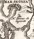 | Details | Coronelli, Vincenzo | 1706 |
| Scarce antique map and plan of Marseilles, France |
|
Coronelli, Vincenzo |
|
| 1706 |
| LOC:77 |
| $275.00 | Coronelli--Vincenzo | Scarce-antique-map-and-plan-of-Marseilles--France | Very scarce map of the Bay of Marseille and surrounding area with a birds-eye view of the city of Marseille, France (Marseglia). Marseilles was the home of France's 'Corps de Galleres' or rowing galleys with lateen-rigged sails. The main fleet of French Navy sailing vessels was headquarted in Toulon, France. The two services were combined in 1744.
<br></br>
Shows a very early view of Marseilles predating the construction and fortification of the town's southern side. In 1660, Louis XIV ensured Marseilles would become the premier commercial port of France in the Mediterranean. Louis commissioned significant new fortifications, and was reported to have said “We noticed that the inhabitants of Marseilles were extremely fond of nice fortresses. We wanted to have our own at the entrance to this great port.”
<br></br>
From "La Francia Divisa in XII Prefetture" , a section of Coronelli's multi-volume "Teatro delle citta e porti principali dell'Europa…" Plate 3 with previous plate number 212. Verso blank |
| 5211 |  | Details | Coronelli, Vincenzo | 1706 |
| Rare antique chart of French islands of Sainte-Marguerite and Saint-Honorat |
|
Coronelli, Vincenzo |
|
| 1706 |
| LOC:77 |
| $265.00 | Coronelli--Vincenzo | Rare-antique-chart-of-French-islands-of--Sainte-Marguerite-and-Saint-Honorat | Rare chart of the a portion of the Cote d'Azur and islands of Sainte-Marguerite and Saint-Honorat off the coast of Cannes, (Canet) France near the Cap de Antibes.
<br></br>
This small well-engraved antique chart is from Coronelli's Teatro della Guerra. TEATRO DELLA GUERRA, DIVISO IN XXXXVIII. PARTI, IN CUI SONO ESATTAMENTE DELINEATI, E COMPENDIOSAMENTE DESCRITTI SIN L'ANNO M.DCC. NAPLES, 1706. Page 25.
<br></br>
Vincenzo Maria Coronelli (1650-1718), is considered as one of Italy's most famous and greatest cartographers and cosmographers to the Republic of Venice. |
| 5214 | 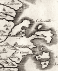 | Details | Coronelli, Vincenzo | 1706 |
| Scarce Italian Map of the French Riviera Cote d'Azur |
|
Coronelli, Vincenzo |
|
| 1706 |
| LOC:77 |
| $265.00 | Coronelli--Vincenzo | Scarce-Italian-Map-of-the-French-Riviera-Cote-d-Azur | Original early eighteenth-century engraved map of the coast of Provence, France at the Cote d'Azur, or French Riviera. Includes the villages of Antibes and Cannes. North is oriented to the upper left.
<br></br>
This small well-engraved antique chart is from Coronelli's Teatro della Guerra. TEATRO DELLA GUERRA, DIVISO IN XXXXVIII. PARTI, IN CUI SONO ESATTAMENTE DELINEATI, E COMPENDIOSAMENTE DESCRITTI SIN L'ANNO M.DCC. NAPLES, 1706. Page 13.
<br></br>
Vincenzo Maria Coronelli (1650-1718), is considered as one of Italy's most famous and greatest cartographers and cosmographers to the Republic of Venice. |
| 5215 | 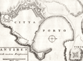 | Details | Coronelli, Vincenzo | 1706 |
| Plan of fortifications at Antibes, France |
|
Coronelli, Vincenzo |
|
| 1706 |
| LOC:77 |
| $265.00 | Coronelli--Vincenzo | Plan-of-fortifications-at-Antibes--France | V. Coronelli's rare antique engraved plan of the port and the Vauban-style fortifications surrounding the city of Antibes, France. Antibes is a town on the French Riviera: the Cote d'Azur. North oriented to the right.
<br></br>
This small well-engraved antique chart is from Coronelli's Teatro della Guerra. TEATRO DELLA GUERRA, DIVISO IN XXXXVIII. PARTI, IN CUI SONO ESATTAMENTE DELINEATI, E COMPENDIOSAMENTE DESCRITTI SIN L'ANNO M.DCC. NAPLES, 1706. Page 25.
<br></br>
Vincenzo Maria Coronelli (1650-1718), is considered as one of Italy's most famous and greatest cartographers and cosmographers to the Republic of Venice. |
| 5217 | 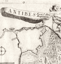 | Details | Coronelli, Vincenzo | 1706 |
| Antique birds-eye view of Antibes, France |
|
Coronelli, Vincenzo |
|
| 1706 |
| LOC:77 |
| $265.00 | Coronelli--Vincenzo | Antique-birds-eye-view-of-Antibes--France | Antique bird's-eye view of Antibes, France. In this scarce early eighteenth-century engraving an angel flies above a fortified port city with a banner that reads: "Antibes Avanti l' ultime Fortificazioni'. That banner flies for Antibes, a village' on the French Riviera or Cote d'Azur, shown with its fortress and harbor.
<br></br>
This small well-engraved antique chart is from Coronelli's Teatro della Guerra. TEATRO DELLA GUERRA, DIVISO IN XXXXVIII. PARTI, IN CUI SONO ESATTAMENTE DELINEATI, E COMPENDIOSAMENTE DESCRITTI SIN L'ANNO M.DCC. NAPLES, 1706.
<br></br>
Vincenzo Maria Coronelli (1650-1718), is considered as one of Italy's most famous and greatest cartographers and cosmographers to the Republic of Venice. |
| 4744 | 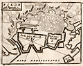 | Details | Coronelli, Vincenzo | 1706 |
| Coronelli's port plan of Toulon, France |
|
Coronelli, Vincenzo |
|
| 1706 |
| LOC:77 |
| $225.00 | Coronelli--Vincenzo | Coronelli-s-port-plan-of-Toulon--France | A fine and rare engraved chart from Coronelli's "Teatro della Guerra" with a plan of Toulon, France along the northern Mediterranean coast. This nice antique engraved chart shows two distinct anchorages for ships: "Porto per i Vascelli de Re" for the King's vessels and "Porto per i Vascelli di Mercanzia" for merchant vessels. The small town of Tolon (Toulon) is shown heavily fortified with then-modern Vauban style walls.
<br></br>
This small well-engraved antique chart is from Coronelli's Teatro della Guerra. TEATRO DELLA GUERRA, DIVISO IN XXXXVIII. PARTI, IN CUI SONO ESATTAMENTE DELINEATI, E COMPENDIOSAMENTE DESCRITTI SIN L'ANNO M.DCC. NAPLES, 1706. (See also our smaller-scale chart of the entire Toulon harbor by Coronelli). Page 8.
<br></br>
Vincenzo Maria Coronelli (1650-1718), is considered as one of Italy's most famous and greatest cartographers and cosmographers to the Republic of Venice. |
| 4745 | 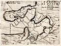 | Details | Coronelli, Vincenzo | 1706 |
| Coronelli's plan of the bay and harbor at Toulon, France |
|
Coronelli, Vincenzo |
|
| 1706 |
| LOC:77 |
| $270.00 | Coronelli--Vincenzo | Coronelli-s-plan-of-the-bay-and-harbor-at-Toulon--France | Attractive antique engraved chart from Coronelli's "Teatro della Guerra" with a harbor chart of Tolon (Toulon), France along the northern Mediterranean coast. Numerous depth soundings crisscross the bay, reflecting several surveys. Little named detail.
<br></br>
This small well-engraved antique chart is from the "Teatro della Guerra." TEATRO DELLA GUERRA, DIVISO IN XXXXVIII. PARTI, IN CUI SONO ESATTAMENTE DELINEATI, E COMPENDIOSAMENTE DESCRITTI SIN L'ANNO M.DCC. NAPLES, 1706. (See also our larger-scale port plan of the town of Toulon by Coronelli). Page 7.
<br></br>
Vincenzo Maria Coronelli (1650-1718), is considered as one of Italy's most famous and greatest cartographers and cosmographers to the Republic of Venice. |
| 5216 |  | Details | Coronelli, Vincenzo | 1706 |
| Fine elevation view of the town of Orleans, France. |
|
Coronelli, Vincenzo |
|
| 1706 |
| LOC:77 |
| $265.00 | Coronelli--Vincenzo | Fine-elevation-view-of-the-town-of-Orleans--France- | Antique elevation view of the town of Orleans, France along the Loire River. With a fine decorative cartouche dedicating the engraving to Carlo Bernardi.
<br></br>
This small well-engraved antique chart is from Coronelli's Teatro della Guerra. TEATRO DELLA GUERRA, DIVISO IN XXXXVIII. PARTI, IN CUI SONO ESATTAMENTE DELINEATI, E COMPENDIOSAMENTE DESCRITTI SIN L'ANNO M.DCC. NAPLES, 1706.
<br></br>
Vincenzo Maria Coronelli (1650-1718), is considered as one of Italy's most famous and greatest cartographers and cosmographers to the Republic of Venice. |