| | Thumbnail | | Creator | Date | Title / Author / Date / Location | Price | | | Description |
| 1102 | 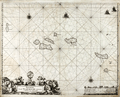 | Details | Loots, Johannes | 1700 |
| Pascaerte vande Vlaemsche Eylanden |
|
Loots, Johannes |
|
| 1700 |
| LOC:9 |
| $2,500.00 | Loots--Johannes | Pascaerte-vande-Vlaemsche-Eylanden | Singular rare nautical chart of the Azores Islands (Vlaemsche = Flemish) by Dutch cartographer Johannes Loots, ca 1700. Pascaerte vande Vlaemsche Eylanden is not recorded in Koeman's Atlantes Neerlandici. <B>No record of another copy of this chart is found online or in cartograhic reference sources.</b> Charts by Johannes Loots are very scarce; only eight charts by Loots are recorded in the Antique Map Price Record covering 210,000 map and chart sales in the last 35 years.
<br></br>
Scrollwork title cartouche with putto and horses led by robed young men and topped with an armillary sphere on a pedestal.
<br></br>
The topography of the Azores islands closely resembles that on an an earlier chart with the same title produced by Arnold Colom but differences in the rhumb lines, cartouches, lattitude marks, compass roses and decorations strongly suggest that this chart was printed from a new plate engraved for Loots.
<br></br>
From Koeman's biography of Johanne's Loots (1665[6] - 1726) we know Loots was born in Amsterdam and is not as is sometimes believed one of the two sons of Anthonie (Theunisz) Jacobsz who named themselves Lootsman to confuse cartographic researchers in future centuries. Loots served an apprenticeship under Hendrick Doncker as a maker of mathematical and nautical instruments including cross-staffs. Loots was accepted into the Guild of Booksellers in 1693 and settled into a shop in the Nieuebrugsteeg 'In de Jong Lootsman'. Two well-known competing catographers lived on the same street- Johannes van Keulen and Hendrick Doncker. |
| 1313 | 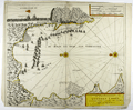 | Details | Loots, Johannes | 1705 |
| Very rare battle plan of the 1704 Capture of Gibraltar. |
|
Loots, Johannes |
|
| 1705 |
| LOC:200 |
| $0.00 | Loots--Johannes | Very-rare-battle-plan-of-the-1704-Capture-of-Gibraltar- | SOLD<br></br><br>Very rare first edition broadsheet chart / view of the Capture of Gibraltar in 1704 by Dutch cartographer Johannes Loots (w. 1693-1726). On 4th August 1704, during the war of the Spanish Succession, an Anglo-Dutch fleet under the command of Admiral George Rooke seized Gibraltar from the Spanish. From dawn on that day and for the next five hours, some 15,000 canons were fired from the fleet into the city. The English majority captors, landed the same morning and not surprisingly encountered little opposition.
<br></br>
Antique Map Price Record has no record of a sale of this chart by Johannes Loots. Charts by Loots are very scarce; only 11 charts by Loots are recorded in the Antique Map Price Record covering 210,000 map and chart sales in the last 35 years. Only two copies of this chart are listed in OCLC World Cat, both at Harvard.
<br></br>
From Koeman's biography of Johanne's Loots (1665[6] - 1726) we know Loots was born in Amsterdam and is not as is sometimes believed one of the two sons of Anthonie (Theunisz) Jacobsz who named themselves Lootsman to confuse cartographic researchers in future centuries. Loots served an apprenticeship under Hendrick Doncker as a maker of mathematical and nautical instruments including cross-staffs. Loots was accepted into the Guild of Booksellers in 1693 and settled into a shop in the Nieuebrugsteeg 'In de Jong Lootsman'.
<br></br>
Title reads: " Tot Amsterdam by Ionnes Loots Boek Zeekard Verkooper en Graadboog Maker inde Nieuwe brugsteed Ionge Lootsman." |
| 1060 | 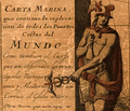 | Details | Loots, Johannes | 1708 |
| Unrecorded Late Golden Age Dutch Sea Chart of the World |
|
Loots, Johannes |
|
| 1708 |
| LOC:0 |
| $95,000.00 | Loots--Johannes | Unrecorded-Late-Golden-Age-Dutch-Sea-Chart-of-the-World | Previously unrecorded nautical chart of the entire world by Dutch cartographer Johannes Loots. Not recorded in Koeman's Atlantes Neerlandici. Not found online. Not in AMPR.
<br></br>
Likely the only Dutch late Golden-Age unrecorded world nautical chart to surface in the 21st century. Differs from other sea charts of the period in that Loots places van Diemen's Land much farther east (13 degrees) than the others (Robijn, Roggeveen, Goos, Morden, Keulen, Wit, Doncker, Moxon, Halley) all of whom tend to place van Diemen's Land at the longitude of the west coast of the Cape York Peninsula (de Fer an exception). One possible explanation for the mis-alignment is that Hendrik Doncker never included van Diemen's Land on his charts, and as Doncker's apprentice, Loots was never required to deal with that area.
<br></br>
Covers the entire world. Loot's newly-discovered chart with title cartouche in four languages (1) Is the only known example of any world chart by Loots. (2) Is of a unique design found in no other world chart. (3) Includes tracks of explorers in the southern passage up to 1708, include le Maire, Schouten, Halley and "Vaisseau St. Louis, 1708" the last, just one year after Loots disolved a partnership with Antoni de Winter and Claas de Vries. (4) Is on Mercator's projection. (5) Shows the “Terre Austral du St. Espirit”.
<br></br>
From Koeman's biography of Johanne's Loots (1665[6]-1726) we know Loots was born in Amsterdam and is not as is sometimes believed one of the two sons of Anthonie (Theunisz) Jacobsz who named themselves Lootsman to confuse cartographic researchers in future centuries. Loots served an apprenticeship under Hendrick Doncker .
<br></br>
Contact for price. |