| | Thumbnail | | Creator | Date | Title / Author / Date / Location | Price | | | Description |
| 6467 | 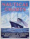 | Details | U.S. Coast and Geodetic Survey | |
| USCGS poster for Nautical Charts |
|
U.S. Coast and Geodetic Survey |
|
|
| LOC:90 |
| $0.00 | U-S--Coast-and-Geodetic-Survey | USCGS-poster-for-Nautical-Charts | SOLD<br><br>Surprisingly scarce poster ca 1970s, originally published in 1959, advertising nautical charts sold by the U.S. Coast and Geodetic Survey in Washington, D. C. A later re-issue published by the National Ocean and Atmospheric Administration (NOAA), National Ocean Service. At one time paper copies of the poster were available by order from the NOAA Distribution Branch but after 2013 products have been only available in PDF print-on-demand delivery.
<br><br>
A map dealer's dream meta-poster!
<br><br>
WorldCat contains only one record of the re-issued poster, at the University of Maryland. No copies of the original 1959 poster are known to me.
<br><br>
Selected dates useful for dating U.S. Coast Survey charts:
<div class="indenttextblocksingle">
<ul style="list-style-type: circle;"></li>
<li>1807 - President Thomas Jefferson establishes Survey of the Coast.</li>
<li>1836 - Survey of the Coast was renamed U.S. Coast Survey. </li>
<li>1878 - U.S. Coast Survey renamed as Coast and Geodetic Survey.</li>
<li>1970 - Coast and Geodetic Survey included within the NOAA and renamed National Geodetic Survey.</li>
<li>2013 - NOAA ends printing of lithographic charts in favor of PDF.</li>
</ul>
</div> |
| 4943 | 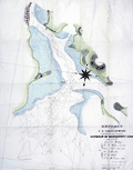 | Details | U.S. Coast and Geodetic Survey | 1835 |
| First chart issued Coast Survey Bridgeport, Conn. |
|
U.S. Coast and Geodetic Survey |
|
| 1835 |
| LOC:53 |
| $0.00 | U-S--Coast-and-Geodetic-Survey | First-chart-issued-Coast-Survey-Bridgeport--Conn- | SOLD<br><br> This "EXTRACT from the U.S. Coast Survey... Harbour of Bridgeport, Conn." <b>is the first navigational chart published by the Coast Survey.</b> It was privately printed in lithography by P. Haas of Washington from the drawing of T.A.M. Craven." (Guthorn. United States Coastal Charts 1783-1861. p. 61.)
<br></br>
Two other charts are notable as early Coast Survey charts printed outside the government: New Haven Harbor (1838) and Newark Bay (1839). Each are distinguished from later printings by the presence of the word "Extract" in the chart's title.
<br></br>
In 1835 the Coast Survey had not fully hit its stride and did not possess printing equipment. This chart was not published in-house but was sent out for printing. It was not until 1844 / 1845 that the Coast Survey printed a chart on their own, that of New York Harbor, in six sheets measuring 63" x 64". Lithographed by P. Haas.</br>
(Burroughs, Charles A. Hassler's First Chart. 1987. https://www.govinfo.gov/content/pkg/GOVPUB-C13-205178772c3ec101c76282e5b214d28e/pdf/GOVPUB-C13-205178772c3ec101c76282e5b214d28e.pdf ) |
| 4953 | 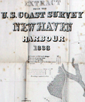 | Details | U.S. Coast and Geodetic Survey | 1838 |
| First chart issued Coast Survey New Haven Harbour |
|
U.S. Coast and Geodetic Survey |
|
| 1838 |
| LOC:0 |
| $425.00 | U-S--Coast-and-Geodetic-Survey | First-chart-issued-Coast-Survey-New-Haven-Harbour | This "Extract from the U.S. Coast Survey New Haven Harbour" Connecticut is one of the three earliest charts published by the United States Coast Survey. No sale of this chart is recorded in the AMPR.
<br></br>
Taken from a Letter from the Secretary of Treasury transmitting a map of New Haven and its harbor in the state of Connecticut. Doc 25th Congress. 1839. |
| 1139 | 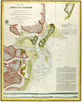 | Details | U.S. Coast and Geodetic Survey | 1846 |
| Antique Rolled Chart of Little Egg Harbor, New Jersey |
|
U.S. Coast and Geodetic Survey |
|
| 1846 |
| LOC:53 |
| $480.00 | U-S--Coast-and-Geodetic-Survey | Antique-Rolled-Chart-of-Little-Egg-Harbor--New-Jersey | Scarce separately issued antique chart (no folds) of <b>Little Egg Harbor, New Jersey</b> published on heavy paper in 1846 by the U.S. Coast Survey. Contains sailing directions, and two long elevation views of the entrance to Little Egg Harbor as seen from sea. Key features include: the New Inlet, Round Shoal, Tucker's Island (with <b>Reuben Tucker's boarding house</b> shown as a triangulation point), Brigantine Channel, Brigantine Beach, Great Thoroughfare, Hunt's Shoals, Anchoring Island, and Hatfield's store.
<br></br>
With numerous depth soundings , anchorages, shoals, and notes on the composition of the sea floor. Electrotype copy no. 2 by Mathiot. Under magnification fine detail is visible assuring the buyer of it's origin as an copperplate (electrotype) engraving. Price when issued was 15 cents.
<br></br>
Little Egg Harbor township is a township in Ocean County, New Jersey. Originally part of Burlington County, Little Egg Harbor took its name from the portion of a bay called Egg Harbor by Dutch sailors for the eggs found in nearby gull nests. The first known account of the town was made by Captain Cornelius Jacobsen May in 1614.
<br></br>
This is a scarce, separately issued, rolled nautical chart of Little Egg Harbor, NJ on heavy paper, not the more common folded version on thin, issued with other charts in an annual report to Congress .
<br></br>
This chart was printed in 1846 from an electrotype copy of the original hand-engraved copper plate, a process the U.S. Coast Survey newly adopted in mid century. As a soft medium, copper plates could only withstand print runs of perhaps 200 copies before the plates wore down. To enable larger print runs, a mold of the original plate was created in wax or another soft medium. Then, using an electro-chemical process ( electrotyping ), the mold was coated with a metal layer, typically copper. Printers were then able to produce output from the new electrotype copper copy, while preserving the original. |
| 1235 | 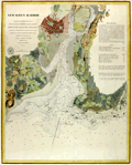 | Details | U.S. Coast and Geodetic Survey | 1847 |
| Antique chart of New Haven, Connecticut and New Haven Harbor |
|
U.S. Coast and Geodetic Survey |
|
| 1847 |
| LOC:53 |
| $550.00 | U-S--Coast-and-Geodetic-Survey | Antique-chart-of-New-Haven--Connecticut-and-New-Haven-Harbor | Rare, rolled, separately issued antique nautical chart of <b>New Haven, Connecticut</b> and harbor on the northern shore of Long Island Sound. Includes West Haven, and Fair Haven. Numerous depth soundings, aids to navigation and navigational hazards are noted such as Savin Rocks, New Haven Light, Quixes Ledge, Round Rock, and Sandy Point. Key features include Fort Wooster, Fort Hale, Farm River, Morris Cove, Mill River, and the Quinnipiac River.
<br></br>
Extensive sailing directions are included at right beginning:
<div class="indenttextblock">
"Bring the Light House to bear E.N.E. and run for it until Fort Hale is in range with the larger of two Church Spires next each other in the village of Fair Haven. You will then be about 1/2 of a mile from the light in 3 fathoms water and a short distance from the buoy upon Adams Fall Ledge. S. 1/2 E. you will see the buoy on the S.W. ledge and still further to the Eastward the beacon on Quixes Ledge. Run into the harbor upon the above mentioned range (Fort Hale and the Spire) until the Light House bears S. by E. when you will be in 2 fathoms soft bottom. Then steer …"
</div>
<br />
Price when issued 15 cents. Triangulation by James Ferguson and Edmund Blunt in 1833.
<br></br>
This chart was printed ca. 1847 from an electrotype copy of the original hand-engraved copper plate, a process the U.S. Coast Survey adopted around that time. As a soft medium, copper plates could only withstand print runs of perhaps 200 copies before the plates wore down. To enable larger print runs, a mold of the original plate was created in wax or another soft medium. Then, using an electro-chemical processs ( electrotyping ), the mold was coated with a metal layer, typically copper. Printers were then able to produce output from the new electrotype copper copy, preserving the original. Electrotype copy no. 3. |
| 5164 | 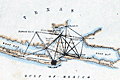 | Details | U.S. Coast and Geodetic Survey | 1848 |
| Antique Map of Galveston Bay and City Bolivar Survey Progress |
|
U.S. Coast and Geodetic Survey |
|
| 1848 |
| LOC:3 |
| $0.00 | U-S--Coast-and-Geodetic-Survey | Antique-Map-of-Galveston-Bay-and-City-Bolivar-Survey-Progress | SOLD
<br></br>
Small antique hand-colored map of southern Galveston Bay showing the progress of an early triangulation survey of the area around Galveston, Texas. The composition of the lines show which lines were between occupied vs. unoccupied survey stations and lines between primary versus secondary stations.
<br></br>
Coverage of this Galveston survey map includes Galveston City, Bolivar Point, Smith's Point, Edward's Point, Highland Bayou, Heron Grove, Parr's Grove and more locations. |
| 3618 | 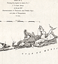 | Details | U.S. Coast and Geodetic Survey | 1849 |
| Reconnaissance of Pensacola and Perdido Bays |
|
U.S. Coast and Geodetic Survey |
|
| 1849 |
| LOC:11 |
| $120.00 | U-S--Coast-and-Geodetic-Survey | Reconnaissance-of-Pensacola-and-Perdido-Bays | Small coastal survey chart of Florida from Bonsecour Bay to the east end of Santa Rosa Island. Includes Pensacola Bay, Escambia Bay, Garcon Point, Blackwater River, Perdido Beach, Mast Bay, Forster's Island, and Fort Pickens. <strong>Price includes hand coloring.</strong>
<br><br>
Chart shows the triangulation network employed in an early survey conducted by the U.S. Coast [and Geodetic] Survey in 1849. Changes in topography inland are indicated by hachuring.
<br></br>
In surveying, triangulation is the process of determining the location of a point by measuring only angles to it from known points at either end of a fixed baseline. The point can then be fixed as the third point of a triangle with one known side and two known angles. Surveying error is minimized if first a mesh of triangles is created at the largest appropriate scale. Then points inside the triangles can all then be accurately located with reference to the triangulation network. |
| 1138 | 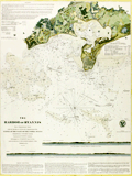 | Details | U.S. Coast and Geodetic Survey | 1850 |
| Antique Rolled Chart of Hyannis Harbor, Massachusetts |
|
U.S. Coast and Geodetic Survey |
|
| 1850 |
| LOC:200 |
| $0.00 | U-S--Coast-and-Geodetic-Survey | Antique-Rolled-Chart-of-Hyannis-Harbor--Massachusetts | SOLD
<br></br>
Fine and quite scarce antique chart of the Harbor of <b>Hyannis, Massachusetts</b> published in 1850 by the U.S. Coast Survey on heavy paper. Contains a list of dangers, a tide table, sailing directions, and two long elevation views of the East and West entrances to Hyannis Harbor as seen from sea. Key features include: Bishop and Clerks Rocks, Point Gammon, Gazette Rock, Gallatin Rocks, Senator Shoal, and Harbor Bluff. With numerous depth soundings and fine topographical detail on the coastal margins. Electrotype copy no. 2 by Mathiot.
<br></br>
Hyannis is the largest of seven villages comprising the town of Barnstable on <b>Cape Cod</b>. The town is best known as the presidential retreat for the Kennedy clan who spent any available downtime at the family compound in Hyannis Port.
<br></br>
This is a scarce, separately issued, rolled nautical chart of Hyannis, MA. on heavy paper, not the more common folded version on thin, trimmed paper that was issued with other charts in an annual report to Congress from the Coast Survey.
<br></br>
Under magnification fine detail is visible assuring the buyer of it's origin as an copperplate (electrotype) engraving. This chart was printed by the U.S. Coast Survey in 1850 from an electrotype copy of the original hand-engraved copper plate, a process the U.S. Coast Survey newly adopted in mid-century and that resulted in incredibly fine detail without the work of re-engraving after every few hundred copies.
<br></br>
As a soft medium, copper plates could only withstand print runs of perhaps 200 copies before the plates wore down. To enable larger print runs, a mold of the original plate was created in wax or another soft medium. Then, using an electro-chemical process ( electrotyping ), the mold was coated with a metal layer, typically copper. Printers were then able to produce output from the new electrotype copper copy, while preserving the original. |
| 3619 |  | Details | U.S. Coast and Geodetic Survey | 1851 |
| Early U.S. Coast Survey Chart of Mare Island Vallejo California |
|
U.S. Coast and Geodetic Survey |
|
| 1851 |
| LOC:3 |
| $85.00 | U-S--Coast-and-Geodetic-Survey | Early-U-S--Coast-Survey-Chart-of-Mare-Island-Vallejo-California | Antique U.S. Coast Survey chart of the Mare Island Strait. Includes Mare Island and Vallejo, California. Topographic detail is rendered through elegant and informative hachuring. Scale 1 / 30,000. |
| 3645 |  | Details | U.S. Coast and Geodetic Survey | 1851 |
| First Edition Antique Nautical Chart of Key West, Florida |
|
U.S. Coast and Geodetic Survey |
|
| 1851 |
| LOC: |
| $0.00 | U-S--Coast-and-Geodetic-Survey | First-Edition-Antique-Nautical-Chart-of-Key-West--Florida | SOLD
<br></br>
Detailed first-edition original antique hydrographic survey chart of the vicinity of Key West, Florida. Includes extensive sailing directions with landmarks, courses, bearings and instructions for entering Key West via several channels. This antique chart, based on a thorough trigonometrical survey, was released by the U.S. Coast Survey in 1851. Contains literally hundreds of depth soundings.
<br></br>
A trigonometrical survey of a portion of the earth's surface is conducted by measuring a single base distance, and connecting it with various points in the tract surveyed by a series of triangles, the angles of which are carefully measured. Relative positions and distances of all parts are computed from these data.
<br></br>
Includes a tide table and very interesting cross-sectional views of elevation of coral heads, (water depth) recorded across several lines on the chart at Sand Key and the reefs at the East Channel. Other noted points include Fleming's Key, Francfort Bank, East Crawfish Key, West Crawfish Key, Mangrove Keys, and Raccoon Key.
<br></br>
With extensive sailing directions for several approaches to Key West, Florida including: the East Channel, the Main Ship Channel ("At Night. Bring the North Stat to range after Key West Light House and stand for it when Sand Key (or Sound Key Light Boat bears S.W. by W. S. 62 degrees W) a vessel drawing over 16 feet of water had better anchor and wait for a pilot".); Rock Key Channel; Sand Key Channel; West Channel; and North West Channel. |
| 1458 |  | Details | U.S. Coast and Geodetic Survey | 1851 |
| Antique Preliminary Nautical Chart of Key West, Florida |
|
U.S. Coast and Geodetic Survey |
|
| 1851 |
| LOC:0 |
| $0.00 | U-S--Coast-and-Geodetic-Survey | Antique-Preliminary-Nautical-Chart-of-Key-West--Florida | SOLD
<br></br>
See another copy of this chart in stock now.
<br></br>
Detailed first-edition original antique hydrographic survey chart of the vicinity of Key West, Florida. |
| 601 |  | Details | U.S. Coast and Geodetic Survey | 1851 |
| Hell Gate and its Approaches |
|
U.S. Coast and Geodetic Survey |
|
| 1851 |
| LOC:0 |
| $0.00 | U-S--Coast-and-Geodetic-Survey | Hell-Gate-and-its-Approaches | <br><br>This item is <b>SOLD</b> but we have found another example of this item that is <a href="https://www.rarecharts.com/ShowDetail/Creator/U-S--Coast-and-Geodetic-Survey/Title/Rare-chart-of-Hell-Gate-and-its-approaches-New-York-City/6531" target="_blank">now in our inventory.</a>
<br></br>
Rolled, antique navigational and hydrographic chart of Hell Gate at the East River of New York City.
With sailing directions and numerous depth soundings. Copper-plate engraving with fine detail. |
| 6531 |  | Details | U.S. Coast and Geodetic Survey | 1851 |
| Rare engraved chart of Hell Gate and its approaches New York City |
|
U.S. Coast and Geodetic Survey |
|
| 1851 |
| LOC:68 |
| $1,550.00 | U-S--Coast-and-Geodetic-Survey | Rare-engraved-chart-of-Hell-Gate-and-its-approaches-New-York-City | Rolled, antique navigational and hydrographic chart of Hell Gate at the East River of New York City, 1851. Original and scarce. With sailing directions and numerous depth soundings. Copper-plate engraving with very fine detail. Not an electrotype copy. Triangulation by Edmund Blunt.
<br><br>
This chart encompasses what was previously a dangerous area to navigate. According to the NOAA website, during the 18th and early 19th century, strong currents and submerged rocks made Hell Gate <a target="_blank" style="color:#9BAFCB" href=" http://celebrating200years.noaa.gov/new_york_charts/hell_gate.html"> "a graveyard for ships"</a>. This chart shows Hell Gate in 1851, the year when the U.S. Army began blasting underwater rocks and obstructions to make the channel safe for marine traffic.
<br></br>
Visible plate mark with ink smudges outside the neatline confirm usage of the intaglio printing method from an engraved copper plate. A separately issued chart, not a marked as a 'survey' or 'preliminary' chart on thin paper issued in the annual reports to Congress. Contains the circular stamp of the U.S. Coast Survey Office. |
| 1007 |  | Details | U.S. Coast and Geodetic Survey | 1851 |
| Coast Survey Atlas (Sketches for the 1851 Annual Report) |
|
U.S. Coast and Geodetic Survey |
|
| 1851 |
| LOC:0 |
| $400.00 | U-S--Coast-and-Geodetic-Survey | Coast-Survey-Atlas-(Sketches-for-the-1851-Annual-Report) | About 57 nautical charts (many folded) in a single volume showing the hydrographic sketches and preliminary surveys of the U.S. East and West Coast. Bookplate: "With the compliments of A.D. Bache", Alexander Dallas Bache (1806-1867), then the superintendent of the United States Coast Survey.
<br></br>
Inserted, loose list of "Coast Survey Charts Published" dated within at March 15, 1853. Lists charts, sketches and preliminary charts, free sketches, and the names and residences for agents selling Coast Survey charts. Size: 9" x 22". On better paper. |
| 1454 |  | Details | U.S. Coast and Geodetic Survey | 1852 |
| Antique Chart of Key West, Florida |
|
U.S. Coast and Geodetic Survey |
|
| 1852 |
| LOC:0 |
| $0.00 | U-S--Coast-and-Geodetic-Survey | Antique-Chart-of-Key-West--Florida | SOLD
<br></br>
Very cool hydrographic survey chart of the vicinity of Key West, Florida long before any bridges. This antique chart, based on a trigonometrical survey, was released by the U.S. Coast Survey in 1852. Includes a tide table and very interesting cross-sectional views of elevation of coral heads, (water depth) recorded across several lines on the chart at Sand Key and the reefs at the East Channel. Other noted points include Fleming's Key, Francfort Bank, East Crawfish Key, West Crawfish Key, Mangrove Keys, and Raccoon Key.
<br></br>
A trigonometrical survey of a portion of the earth's surface is conducted by measuring a single base distance, and connecting it with various points in the tract surveyed by a series of triangles, the angles of which are carefully measured. Relative positions and distances of all parts are computed from these data.
<br></br>
With extensive sailing directions for several key approaches to Key West including: the East Channel, the Main Ship Channel ("At Night. Bring the North Stat to range after Key West Light House and stand for it when Sand Key (or Sound Key Light Boast bears S.W. by W. S. 62 degrees W) a vessel drawing over 16 feet of water had better anchor and wait for a pilot".); Rock Key Channel; Sand Key Channel; West Channel; and North West Channel. Second Edition. |
| 1155 |  | Details | U.S. Coast and Geodetic Survey | 1853 |
| Antique Rolled Chart of Cape Fear, North Carolina |
|
U.S. Coast and Geodetic Survey |
|
| 1853 |
| LOC:0 |
| $0.00 | U-S--Coast-and-Geodetic-Survey | Antique-Rolled-Chart-of-Cape-Fear--North-Carolina | SOLD
<br></br>
Scarce separately issued rolled antique chart (no folds) from 1853 of <b>Cape Fear, North Carolina</b> with extensive sailing directions. Coverage on this fine old engraving includes "Smith's Island", now Bald Head Island; "Smithville", now <b>Southport, NC</b>; Federal Point; Champagne Creek; Zeek's Island, Battery Island and Striking Island. Numerous small waterways are charted including Dozier's Creek, Elizabeth Creek, Dutchman Creek, and Price's Creek.
<br></br>
Depicts <b>Fort Caswell</b> on Oak Island protecting the entrance to the Cape Fear River. That pentagonal shaped structure, completed in 1836, was designed to house 61 cannon. Fort Caswell was named for Governor Richard Caswell, a North Carolina hero of the American Revolution. A lawyer and surveyor by training, Caswell represented North Carolina in the Continental Congress of 1774 and 1775. As a Patriot officer in the American Revolutionary War, Caswell led North Carolina militiamen in the Battle of Moore's Creek Bridge.
<br></br>
The chart would have facilitated navigation from the Atlantic Ocean past Cape Fear though the Main Ship Channel to the Cape Fear River and Wilmington through its use of numerous depth soundings, buoy locations, sandbars, isobaths, and bearing lines.
<br></br>
This is a scarce, separately issued, rolled nautical chart of Cape Fear, NC on heavy paper, not the more common folded version on thin, trimmed paper that was issued by the Coast Survey with other charts in an annual report to Congress. With the circular logo of the Coast Survey Office. Price when issued was 15 cents.
<br></br>
Very fine detail on the chart and lack of attribution to electrotype reproduction suggest that this chart is based on the Coast Survey's original hand-engraved copper plate . |
| 853 |  | Details | U.S. Coast and Geodetic Survey | 1853 |
| Antique engraved nautical chart of the entrance to San Diego, California |
|
U.S. Coast and Geodetic Survey |
|
| 1853 |
| LOC:0 |
| $0.00 | U-S--Coast-and-Geodetic-Survey | Antique-engraved-nautical-chart-of-the-entrance-to-San-Diego--California | SOLD<br></br>
Engraved antique nautical chart of the entrance to San Diego Bay, in California on a large sheet of heavy paper with no folds . Noted features include Point Loma, Ballast Point, Zuniga Shoal, and "La Playa" the original harbor where goods were transferred to and from ships calling at the port. At right is a sketch of the wider area including the San Diego Bay area and extending to the Coronados Islands, four islands belonging to Mexico between 15 and 20 miles south of San Diego.
<br></br>
Considered to be one of the best natural harbors on the west coast of North America, San Diego was colonized by Spain beginning in 1769 and served as base headquarters of major ships of the United States Navy in the Pacific until just before the United States entered World War II.
<br></br>
Early electrotype copy. Never folded, this is a separately issued chart of the harbor with 4" wide margins and a prominent platemark. Total size is 21" x 18".
<br></br>
Relief shown by hachures; soundings in feet. Includes sailing directions. In upper margin "Presented under authority of an act of Congress of the United States of June 3d 1844 by direction of the Treasury Department, A.D. Bache Superintendent Coast Survey." "J No. 4."
<br></br>
Electrotype copy number 1 by Mathiot. |
| 664 |  | Details | U.S. Coast and Geodetic Survey | 1853 |
| City of San Francisco, California |
|
U.S. Coast and Geodetic Survey |
|
| 1853 |
| LOC:63 |
| $1,400.00 | U-S--Coast-and-Geodetic-Survey | City-of-San-Francisco--California | Antique electrotype engraved plan of the booming town of San Francisco, California made in 1853 during the California gold rush. On a 25" x 33" sheet of heavy paper, never folded. Key named features include: Tonquin Shoal, Wreck of the Tonquin, Blossom Rock, Mission Rock, Point San Quentin, Mission de Dolores, Rincon Point, Mission Bay, Steamboat Point, Cunningham's Wharf, Law's Wharf, Broadway Wharf, Pacific Wharf, and Portsmouth Square.
<br></br>
The town is shown laid out into blocks with individual buildings. Numerous streets are identified including Market Street, Pine Street, Lombard Street and Broad Way. Includes numerous soundings and contour lines.
<br><br/>
This antique chart should not be confused with those similar copies that were issued with dozens of others as part of a Report to Congress, most on thin paper with folds that often show condition issues. This original mid 19th century survivor is a large, separately issued example on thick wove paper that has been stored either rolled of flat with no folds. Price 50 Cents. Verified I.I. Stevens . Outlines and Topography engraved by Max. F.O. Strobel; Lettering by E.F. Woodward. With the circular logo of the Coast Survey Depot. Number 627. |
| 606 |  | Details | U.S. Coast and Geodetic Survey | 1853 |
| Western Coast of U.S. San Francisco to San Diego 1853 |
|
U.S. Coast and Geodetic Survey |
|
| 1853 |
| LOC:0 |
| $0.00 | U-S--Coast-and-Geodetic-Survey | Western-Coast-of-U-S--San-Francisco-to-San-Diego-1853 | SOLD <br></br>
Antique chart focused on the coastline between San Francisco and San Diego, California. Produced by the U.S. Coast Survey in 1853, a time when the United States Pacific coastal states were lightly populated. Scarce, separately issued, electrotype copy. A rolled chart of the California coast, not one of the common folded versions on thin paper that were issued with other charts in an annual report from the U.S. Coast Survey to Congress. |
| 1026 | 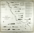 | Details | U.S. Coast and Geodetic Survey | 1853 |
| Western Coast of U.S. San Francisco to San Diego |
|
U.S. Coast and Geodetic Survey |
|
| 1853 |
| LOC:0 |
| $0.00 | U-S--Coast-and-Geodetic-Survey | Western-Coast-of-U-S--San-Francisco-to-San-Diego | SOLD
<br><br/>
Fascinating old antique nautical chart of the western coast of California focused on the coastline between <b>San Francisco</b> and <b>San Diego</b>, California. Includes Los Coronados (Coronado Islands), San Clemente Island, Alcatraz Island, San Nicholas Island, Point Loma, Point Conception and many other geographic locations.
<br></br>
The antique chart was produced by the U.S. Coast Survey in 1853, a time when the United States Pacific coastal states were lightly populated (by settlers). In fact, one of the settlements noted above San Diego in a wide coastal plain is referred to on the map as <b>"El Pueblo de Los Angeles". </b> That settlement had been created by the Spanish only in 1781.
<br></br>
Noted habitations include Monterrey, the Mission of Carmel, San Diego, and San Francisco. The chart is decorated with 17 decorative nicely-engraved coastal profile views including Catalina Harbor, Moro Rock, Point Sur, and the Entrance to San Francisco Bay.
<br></br>
This is a scarce, separately issued, rolled chart of the California coast, not one of the common folded versions on thin paper that were issued with other charts in an annual report to Congress from the Coast Survey.
<br></br>
This antique chart was printed in 1853 from an electrotype copy of the original hand-engraved copper plate, a process the U.S. Coast Survey adopted around 1850. As a soft medium, copper plates could only withstand print runs of perhaps 200 copies before the plates wore down. To enable larger print runs, a mold of the original plate was created in wax or another soft medium. Then, using an electro-chemical processs ( electrotyping ), the mold was coated with a metal layer, typically copper. Printers were then able to produce output from the new electrotype copper copy, while preserving the original. Electrotype copy no. 10. Sheet size 30"x30". Scale 1 / 1,200,000. |
| 1268 | 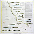 | Details | U.S. Coast and Geodetic Survey | 1853 |
| Antique rolled U.S. Coast Survey chart from San Francisco to San Diego |
|
U.S. Coast and Geodetic Survey |
|
| 1853 |
| LOC:0 |
| $0.00 | U-S--Coast-and-Geodetic-Survey | Antique-rolled-U-S--Coast-Survey-chart-from-San-Francisco-to-San-Diego | SOLD<br></br>
Attractive antique nautical chart of the western coast of California focused on the coastline between <b>San Francisco</b> and <b>San Diego</b>, California. Includes Los Coronados (Coronado Islands), San Clemente Island, Alcatraz Island, San Nicholas Island, Point Loma, Point Conception and many other geographic locations.
<br></br>
This is a scarce, separately issued, rolled chart of the California coast, not one of the common folded versions on thin paper that were issued with other charts in an annual report to Congress from the Coast Survey.
<br></br>
The antique chart was produced by the U.S. Coast Survey in 1853, a time when the United States Pacific coastal states were lightly populated (by settlers). In fact, one of the settlements noted above San Diego in a wide coastal plain is referred to on the map as <b>"El Pueblo de Los Angeles". </b> That settlement had been created by the Spanish only in 1781.
<br></br>
Noted habitations include Monterrey, the Mission of Carmel, San Diego, and San Francisco. The chart is decorated with 17 decorative nicely-engraved coastal profile views including Catalina Harbor, Moro Rock, Point Sur, and the Entrance to San Francisco Bay.
<br></br>
This antique chart was printed in 1853 from an electrotype copy of the original hand-engraved copper plate, a process the U.S. Coast Survey adopted around 1850. As a soft medium, copper plates could only withstand print runs of perhaps 200 copies before the plates wore down. To enable larger print runs, a mold of the original plate was created in wax or another soft medium. Then, using an electro-chemical processs ( electrotyping ), the mold was coated with a metal layer, typically copper. Printers were then able to produce output from the new electrotype copper copy, while preserving the original. Electrotype copy no. 10. Sheet size 30"x30". Scale 1 / 1,200,000. |
| 665 | 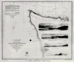 | Details | U.S. Coast and Geodetic Survey | 1853 |
| Northwest Coast of Washington State |
|
U.S. Coast and Geodetic Survey |
|
| 1853 |
| LOC:0 |
| $0.00 | U-S--Coast-and-Geodetic-Survey | Northwest-Coast-of-Washington-State | SOLD
<br><br/>
Attractive original chart of the Olympic Peninsular coast of the Washington territory in the year it was established - 1853. The Washington territory was not admitted to the Union until 1889. Includes coastline both along the Pacific Ocean and the Strait of Juan de Fuca. Very fine condition.
<br><br/>
Detailed soundings and hydrographic detail of the Washington coast including Gray's Harbor, Cape Flattery, Fresh Water Bay, False Dungeness, Protection Island, Point Hudson, Callam Bay, and Admiralty Inlet. These additional areas are shown in outline only : Vancouver Island, Victoria Harbor, Haro Strait, San Juan Island, Port San Juan, Lopez Island, Rosario Strait, and Smith's Island.
<br><br/>
With finely engraved inset views of these features: Duncan's Rock, Tatoosh Island, Cape Flattery, Flattery Rocks, White Rock, Destruction Island, Sail Rock, Pt. Grenville.
<br><br/>
This antique chart should not be confused with those similar copies issued with dozens of other maps as part of a Report to Congress, most on thin paper with folds that often show condition issues. This original mid 19th century survivor is a large, separately issued chart on thick wove paper that has been stored either rolled of flat with no folds.
<br><br/>
Engraved by McCoy, Woodward, and Smith. Includes sailing directions. With the circular logo of the Coast Survey Depot. |
| 5448 | 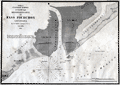 | Details | U.S. Coast and Geodetic Survey | 1854 |
| Antique chart of Pass Fourchon Lafourche Parish Louisiana |
|
U.S. Coast and Geodetic Survey |
|
| 1854 |
| LOC:78 |
| $200.00 | U-S--Coast-and-Geodetic-Survey | Antique-chart-of-Pass-Fourchon-Lafourche-Parish-Louisiana | Antique lithographed chart of Pass Fourchon, Louisiana, at the mouth of Bayou Lafourche [1] where it entered the Gulf of Mexico in 1854. Shows Bird Island at bottom left and Lake Champagne to the right, today after erosion, no longer inland- called Bay Champagne. The pass shown on the chart no longer exists, it is closed and maritime traffic utilizes Belle Pass which lies to the west of the Pass Fourchon. The old Pass Fourchon channel is used to access Port Fourchon.
<br></br>
Port Fourchon is located about 60 miles SSW of New Orleans, Louisiana. The port is the marine support base for more than 90% of the Gulf of Mexico's deep-water oil production.
<br></br>
Drawn by F.W. Gerdes. Engineered by Bartle and Bradley. Lithographed by Bien and Sterner, New York.
<br></br>
[1] In 1854 Bayou Lafourche was an active distributary of the Mississippi River. Bayou Lafourche has not been navigable from the Mississippi River since 1905 when a dam was built at Donaldsonville, La. but prior to that time the portion of the Bayou north of the ICWW served as an important commercial artery to New Orleans and other points on the Mississippi River.
<br></br>
<div>
<img src="/ZoomifyImages/SC_993/SC_993_400x300.jpg" alt="" width="300" align="bottom" style="margin: 0px 10px 10px 0"/>
<span style="vertical-align: middle;">
<br>
<a href="https://www.rarecharts.com/ShowDetail/Creator/Anonymous/Title/Steamboat-Bill-of-Lading-for-Valence-Plantation/993" target="_blank">Steamboat Bill of Lading for Valence Plantation on Bayou Lafourche</a>
</span>
</div> |
| 2565 | 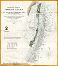 | Details | U.S. Coast and Geodetic Survey | 1855 |
| Preliminary Chart of Florida Reefs from Key Biscayne |
|
U.S. Coast and Geodetic Survey |
|
| 1855 |
| LOC:200 |
| $475.00 | U-S--Coast-and-Geodetic-Survey | Preliminary-Chart-of-Florida-Reefs-from-Key-Biscayne | Fine antique hydrographic survey chart of <b>Biscayne Bay</b>, Florida and surrounding area. Hundreds, perhaps thousands of depth soundings.
<br></br>
Miami, Florida is distinctly noted at the very top while a lighthouse is noted at the southern tip of Cape Florida. Other named features include: Old Rhodes Bank, Caesars Creek Bank, Elliott's Key, Triumph Reef, and Virginia Key.
<br></br>
Recommended reference for <b>treasure hunters</b>. Shows some locations of wrecks, dangerous reefs and banks.
<br></br>
Includes a list of abbreviations used to denote the sea floor composition (ex: S for Sand , C for clay).
<br></br>
A preliminary reduced-format hydrographic survey chart from a U.S. Coast Survey atlas with the U.S.C.G.S. circular winged logo. On thin paper with folds as issued. |
| 1099 |  | Details | U.S. Coast and Geodetic Survey | 1859 |
| Entrance to San Francisco Bay California 1859 |
|
U.S. Coast and Geodetic Survey |
|
| 1859 |
| LOC:0 |
| $2,500.00 | U-S--Coast-and-Geodetic-Survey | Entrance-to-San-Francisco-Bay-California-1859 | Superb, large, antique U.S. Coast Survey chart of <b>San Francisco Bay</b>, the city of San Francisco, California, and lower Marin County, California on heavy paper with no folds. Laid down nicely to board. Produced just 10 years after the beginning of the California Gold Rush it shows numerous soundings and aids to navigation including Fort Point Light, Point Bonita Light, Yerba Buena Light, and Alcatraz Light.
<BR> </BR>
Coverage includes San Francisco and Sausalito and the surrounding areas and is the original 1859 electrotype edition not a later corrected version. Like later editions, the bottom of the chart contains two views of the bay- both inbound and outbound the port showing both steam and sail-powered vessels underway and at anchor. This 1859 edition contains a third engraved view not found in later editions- <b>"View of the Entrance to San Pablo Bay from near Angel Island"</b>. In later editions that view was removed to make room for notes and tables.
<BR> </BR>
Named points of interest include the Presidio, Oakland, Cliff House, Ocean House, Sausalito, Alcatraz Island, Mission Bay, San Leandro, Yerba Buena Island, Mission de Delores, Table Mountain, Brooklyn, Alameda, and of course the Golden Gate (with no bridge).
<BR> </BR>
This chart was printed in 1859 from an electrotype copy of the original hand-engraved copper plate, a process the U.S. Coast Survey adopted around 1850. As a soft medium, copper plates could only withstand print runs of perhaps 200 copies before the plates wore down. To enable larger print runs, a mold of the original plate was created in wax or another soft medium. Then, using an electro-chemical processs ( electrotyping ), the mold was coated with a metal layer, typically copper. Printers were then able to produce output from the new electrotype copper copy, while preserving the original. Electrotype copy no. 2. With the circular stamp of the U.S. Coast Survey. |
| 3668 |  | Details | U.S. Coast and Geodetic Survey | 1860 |
| Fine antique chart of Drake's Bay, California |
|
U.S. Coast and Geodetic Survey |
|
| 1860 |
| LOC:63 |
| $650.00 | U-S--Coast-and-Geodetic-Survey | Fine-antique-chart-of-Drake-s--Bay--California | Very attractive scarce antique engraved chart of Drake's Bay, California on the Pacific Ocean just northwest of San Francisco. Coverage extends southward as far as Duxbury Reef. Includes sailing directions, notes on dangers, soundings and abbreviations, and tide table.
<br><br/>
A surviving survey file copy from the U.S. Geological Survey Library. With an oval faded ink stamp from that agency. Map number in MS at bottom corners as typical for surveyor's file copies.
<br><br/>
Now a part of Point Reyes National Seashore, the area covered by this old chart includes detailed topographical information and is generally devoid of named features. "Breakers" are noted in numerous areas all along the beaches. Numerous depth soundings.
<br><br/>
This antique chart should not be confused with those similar copies that were issued with dozens of others as part of a Report to Congress, most on thin paper with folds that often show condition issues. This original mid 19th century survivor is a large, separately issued example on crisp, strong paper that has been stored rolled with a NO FOLDS. Price 20 cents. NO logo of the Coast Survey Office. Number 629. |
| 682 |  | Details | U.S. Coast and Geodetic Survey | 1860 |
| Albemarle Sound North Carolina |
|
U.S. Coast and Geodetic Survey |
|
| 1860 |
| LOC:52 |
| $675.00 | U-S--Coast-and-Geodetic-Survey | Albemarle-Sound-North-Carolina | Original, antique rolled U.S. Coast Survey chart of the Western portion of Albemarle Sound published in 1860. Produced under the supervision of A.D. Bache, Superintendent of the Survey of the Coast of the United States. Within a mile or so of the riverine margins each building, field, and plot of land are drawn in fine detail. With sailing directions and an explanation of navigation using the ranges. Based on triangulation and hydrography executed between 1847 - 1849.
<br></br>
Coverage of this fine antique chart include the towns of Plymouth, Edenton, Columbia, Hertford, Nixonton, and Elizabeth City, North Carolina; the Cashai (Cashie) River; Pocosson Swamp; Roanoke River; Chowan River; Bull Bay; Scuppernong River; Perquamons (Perquimans) River; Bear Garden Point; Little River; Redbank Land; and Truebloods Point.
<br></br>
This antique navigation chart should not be confused with those similar copies issued as part of a Report to Congress, most on thin paper with folds that often show condition issues. This original mid 19th century survivor is a large, separately issued example on thick paper that has been stored either rolled of flat with no folds.
<br></br>
Numerous soundings, lighthouses, and other aids to navigation are noted. With the logo of the Coast Survey Office. Price $1.50 when issued. |
| 1269 |  | Details | U.S. Coast and Geodetic Survey | 1864 |
| Western Coast of U.S. from Umpqua River to the Boundary |
|
U.S. Coast and Geodetic Survey |
|
| 1864 |
| LOC:63 |
| $0.00 | U-S--Coast-and-Geodetic-Survey | Western-Coast-of-U-S--from-Umpqua-River-to-the-Boundary | SOLD<br></br>
Rare, rolled, separately issued antique nautical chart ( 1864 ed. ) of the western coast of California focused on the Pacific coastline between the <b>Umpquah River, Oregon</b> north to the Canadian border. Noted with several habitations including Seattle, Astoria, and Olympia, Washington; Victoria, British Columbia; and Fort Langley. Many of the San Juan Islands are identified by name including Vancouver Island, San Juan, Lopez, Fidalgo, and <b> Guemes Island</b>.
<br></br>
This antique sea chart is enlivened with eight attractive engraved inset coastal profile views including: the Entrance to Columbia River / Cape Disappointment, Tatoosh Island, Flattery Rocks, Destruction Island, Tillamook Head, Cape Perpetua, and Cape Lookout.
<br></br>
The chart was first produced by the U.S. Coast Survey in 1855, a point in time when A.D. Bache was Superintendent.
<br></br>
This is a scarce, separately issued, rolled nautical chart of the area, not the more common folded version on thin paper that was issued with other charts in an annual report to Congress from the Coast Survey.
<br></br>
This chart was printed in 1864 from an electrotype copy of the original hand-engraved copper plate, a process the U.S. Coast Survey adopted around 1850. As a soft medium, copper plates could only withstand print runs of perhaps 200 copies before the plates wore down. To enable larger print runs, a mold of the original plate was created in wax or another soft medium. Then, using an electro-chemical processs ( electrotyping ), the mold was coated with a metal layer, typically copper. Printers were then able to produce output from the new electrotype copper copy, while preserving the original. Electrotype copy no. 6, corrected to 1864. Sheet size 30"x30". Scale 1 / 1,200,000. |
| 607 |  | Details | U.S. Coast and Geodetic Survey | 1864 |
| Western Coast of U.S. from Umpqua River to the Boundary Uncolored |
|
U.S. Coast and Geodetic Survey |
|
| 1864 |
| LOC:63 |
| $475.00 | U-S--Coast-and-Geodetic-Survey | Western-Coast-of-U-S--from-Umpqua-River-to-the-Boundary-Uncolored | Rare, rolled, separately issued antique nautical chart ( 1864 ed. ) of the western coast of California focused on the Pacific coastline between the Umpquah River, Oregon north to the Canadian border. Noted with several habitations including Seattle, Astoria, and Olympia, Washington; Victoria, British Columbia; and Fort Langley. Many of the San Juan Islands are identified by name including Vancouver Island, San Juan, Lopez, Fidalgo, and <b> Guemes Island</b>.
<br></br>
This antique sea chart is enlivened with eight attractive engraved inset coastal profile views including: the Entrance to Columbia River / Cape Disappointment, Tatoosh Island, Flattery Rocks, Destruction Island, Tillamook Head, Cape Perpetua, and Cape Lookout.
<br></br>
The chart was first produced by the U.S. Coast Survey in 1855, a point in time when A.D. Bache was Superintendent.
<br></br>
This is a scarce, separately issued, rolled nautical chart of the area, not the more common folded version on thin paper that was issued with other charts in an annual report to Congress from the Coast Survey.
<br></br>
This chart was printed in 1864 from an electrotype copy of the original hand-engraved copper plate, a process the U.S. Coast Survey adopted around 1850. As a soft medium, copper plates could only withstand print runs of perhaps 200 copies before the plates wore down. To enable larger print runs, a mold of the original plate was created in wax or another soft medium. Then, using an electro-chemical process ( electrotyping ), the mold was coated with a metal layer, typically copper. Printers were then able to produce output from the new electrotype copper copy, while preserving the original. Electrotype copy no. 6, corrected to 1864." Scale 1 / 1,200,000. |
| 4901 | 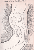 | Details | U.S. Coast and Geodetic Survey | 1865 |
| Antique Mississippi River Charts of Shoals and Sand Bars |
|
U.S. Coast and Geodetic Survey |
|
| 1865 |
| LOC:2001 |
| $500.00 | U-S--Coast-and-Geodetic-Survey | Antique-Mississippi-River-Charts-of-Shoals-and-Sand-Bars | Rare, separately published charts (23) of critical navigational areas on the Mississippi River and the Ohio River. A supplement of charts to accompany the <b>"Letter of the Secretary of the Navy communicating the report of the commission appointed under the joint resolution of Congress, approved June 30, 1864," </b> (Source: Online) <div class="indenttextblock"> "to select the most approved site for a navy yard or naval station on the Mississippi River or upon one of its tributaries and recommending a appropriation to cover the expenses of said commission." </div> The maps were not of proposed locations for the new Navy yard but of shoal or shallow areas of the Mississippi River. These shallow sand bars and narrow channels could impede the movement of vessels of vessels to the new yard:
<div class="indenttextblock">
"A series of topographical sketches of some of the difficult places of navigation on the Mississippi between Carondolet and Memphis and in the Ohio between Cairo and Cincinnati. They will have a value in furnishing means of comparison in future studies of the beds of these rivers."
</div>
<br>
Twenty-one charts (sketches) for the Mississippi River and two charts for the Ohio River including:
<div class="indenttextblocksingle">
<ul style="list-style-type: circle;">
<li>Sketch No. 1 Jefferson Barracks Bar</li>
<li>Sketch No. 3 Widow Beard's Island</li>
<li>Sketch No. 5 Penitentiary Shoal</li>
</ul>
</div>
The surveys were conducted by a Coast Survey party attached to the command of Admiral Lee, headed by F.H. Gerdes Chief of the Mississippi squadron topographical engineers.
<br></br>
The expenses of the commission included a whopping $870 to G.W. Blunt, $10 per diem from November 10, 1864 to February 4, 1865. From this expense we know that Blunt also was actively involved in the survey's that produced these maps. |
| 542 |  | Details | U.S. Coast and Geodetic Survey | 1866 |
| New York Bay and Harbor. Chart 20. |
|
U.S. Coast and Geodetic Survey |
|
| 1866 |
| LOC:0 |
| $0.00 | U-S--Coast-and-Geodetic-Survey | New-York-Bay-and-Harbor---Chart-20- | SOLD<br><br>Detailed, antique, original folding harbor chart on linen of Manhattan, New York Bay, and surrounding areas published immediately after the U.S. Civil War. Coverage includes Staten Island, the Hudson River, Newark Bay, and the Rockaway Peninsula. Produced under the direction of A.D. Bache, a great-grandson of Benjamin Franklin (Guthorn, 1984). The chart is based on triangulation of J. Ferguson and E. Blunt.
<br></br>
This chart is even more scarce and unusual because of its provenance and because it is a folding chart. The chart was dissected into 8 sections and mounted to linen at the time it was issued. Folded the chart measures 8" x 14". Separately issued by the U.S. Coast Survey in 1866 for use at sea, this chart is NOT the commonly found Coast Survey sketch/chart on thin paper.
<br><br/>
This chart has an interesting provenance as it carries the manuscript signature of Charles DW Brownell, Bristol, Rhode Island on the inside front cover. Charles deWolf Brownell (1822 - 1909) was born in Providence Rhode Island, educated in the law, and later settled on a career as an artist for health reasons. Brownell travelled widely to Cuba, the Caribbean and Europe. He is best known for his landscapes but produced several paintings of maritime subjects including "The Burning of the Gaspee". Brownell lived in New York City from 1860 - 1865. <br><br/>
With well-worn embossed black boards and manuscript notation on verso- "New York Harbor". |
| 3667 |  | Details | U.S. Coast and Geodetic Survey | 1867 |
| Fine antique chart of Suisun Bay, California |
|
U.S. Coast and Geodetic Survey |
|
| 1867 |
| LOC:63 |
| $800.00 | U-S--Coast-and-Geodetic-Survey | Fine-antique-chart-of-Suisun-Bay--California | Very attractive scarce antique engraved chart of Suisun Bay, California northwest of San Francisco Bay. Key features include Grizzly Island, Van Sickle's Island, Chipp's Island, Sherman Island, the Carquines Straits, and the towns of Antioch, Benicia and Martinez.
<br></br>
Rare U.S. Coast Survey separately published chart of Suisun Bay, California. For the collector of California cartography, a very special chart of Suisun Bay which lies at the confluence of the Sacramento and San Joaquin Rivers, forming the entrance to the Sacramento–San Joaquin River Delta. Dated within to 1867. With fine detail of interior topography. Assumed to be the first edition.
<br></br>
The map covers from Benicia and the Karquines Strait in the west as far as Sherman Island in the east and from Grizzly Island south to the San Joaquin River. Includes countless depth soundings in feet, detailed notes on tides. Several towns and cities are identified, including Martinez, Benicia, and Collinsville.
<br></br>
This plate is not from the common 1867 Report of the Superintendent of the United States Coast Survey. The chart is an original copper-plate engraved chart 32" x 17" on a huge sheet of crisp surveyor's paper 30" x 40". Not an electrotype copy. This engraving was printed from the original hand-engraved copper plate. Evidence of a wide platemark. Price 75 cents when issued.
<br></br>
This chart of Suisun Bay is unlike most Coast Survey charts we have handled. It is on crisp oversize paper and has not been folded into a Coast Survey atlas (nor was it printed for that purpose). The chart does not carry the caveat at upper right "Electrotype Copy No. X". Based on that as well as by the markings on this chart and other items purchased in the same sales lot we feel there is a high probability that the chart was a surplus proof and or reference file copy of the U.S.G.S. |
| 3578 |  | Details | U.S. Coast and Geodetic Survey | 1867 |
| Point Sal, California |
|
U.S. Coast and Geodetic Survey |
|
| 1867 |
| LOC:63 |
| $375.00 | U-S--Coast-and-Geodetic-Survey | Point-Sal--California | Rare U.S. Coast Survey chart of Point Sal, California. For the collector of California cartography, a special chart of Point Sal which lies on California's Pacific Coast somewhat midway between Santa Barbara and San Luis Obispo. Original copper-plate engraved chart 14" x 17" on a huge sheet of crisp surveyor's paper in total 20" x 26". Assumed to be the first edition.
<br></br>
Not an electrotype copy. This engraving was printed from the original hand-engraved copper plate. Evidence of a wide platemark. Price 15 cents when issued.
<br></br>
This chart of Point Sal is unlike most Coast Survey charts we have handled. It is on quality oversize paper and has not been folded into a Coast Survey atlas (nor was it printed for that purpose). The chart does not carrry the caveat at upper right "Electrotype Copy No. X". Based on that as well as by the markings on other items purchased in the same sales lot we feel there is a high probability that the chart was a surplus proof and or reference file copy of the U.S.G.S. The date appears at bottom left along with the map number "660", both to facilitate searching a the files. Chart no. 660. |
| 3583 | 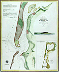 | Details | U.S. Coast and Geodetic Survey | 1867 |
| Humboldt Bay, California |
|
U.S. Coast and Geodetic Survey |
|
| 1867 |
| LOC:63 |
| $475.00 | U-S--Coast-and-Geodetic-Survey | Humboldt-Bay--California | Rare and extremely attractive U.S. Coast Survey separately-published chart of Humboldt Bay, California. For the collector of California cartography, a very special chart of Humboldt Bay which lies on the Pacific Coast of California just below the town of Eureka, CA. With a elevation profile view of Red Bluff Entrance to Humboldt Bay as it then appeared from 2 1/2 miles offshore and a small-scale chart of the entire Humboldt Bay environs. Second edition. Dated 1852 but probably printed around 1867. MS chart number in margin "632".
<br></br>
Towns shown include Humboldt, Eureka and Bucksport. Other features include the site of a proposed lighthouse and a beacon, Elk River, Indian Island, and Howard House in Humboldt.
<br></br>
This plate is not from the common 1867 Report of the Superintendent of the United States Coast Survey. The chart is an original copper-plate engraved chart 14" x 17" on a huge sheet of crisp surveyor's paper 20" x 26". Not an electrotype copy. This engraving was printed from the original hand-engraved copper plate. Evidence of a wide platemark. Price when issued 15 cents.
<br></br>
This chart of Humboldt Bay is unlike most Coast Survey charts we have handled. It is on crisp oversize paper and has not been folded into a Coast Survey atlas (nor was it printed for that purpose). The chart does not carry the caveat at upper right "Electrotype Copy No. X". Based on that as well as by the markings on this chart and other items purchased in the same sales lot we feel there is a high probability that the chart was a surplus proof and or reference file copy of the U.S.G.S. |
| 834 | 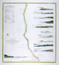 | Details | U.S. Coast and Geodetic Survey | 1869 |
| Western Coast of U.S. from San Francisco to Umpquah (Umpqua) River |
|
U.S. Coast and Geodetic Survey |
|
| 1869 |
| LOC:63 |
| $675.00 | U-S--Coast-and-Geodetic-Survey | Western-Coast-of-U-S--from-San-Francisco-to-Umpquah-(Umpqua)-River | Very attractive antique nautical chart of the <b>western coast of California</b> focused on the Pacific coastline between <b>San Francisco, California</b> and the Umpqua River, Oregon. This scarce, rolled, separately issued chart, corrected to 1869, was first published in 1854 by the U.S. Coast Survey. Noted habitations and geographical features include Empire City, Koos Bay, and Port Orford or Ewing Harbor, Oregon; Crescent City, Reddings Rock, Eureka, Mendocino City, Haven's Anchorage, Bodega Bay, Pt. Reyes, Alcatraz Island, Oakland, Alameda, Union City and San Francisco Bay, California. Numerous soundings, navigational hazards, and aids to navigation are identified.
<br></br>
This antique sea chart is enlivened with twelve attractive hand-colored <b>inset coastal elevation views</b> including: the Entrance to San Francisco Bay, Point Arena, Mendocino City Cove, Trinidad Head and City, Cape Mendocino, Red Bluff Entrance to Humboldt Bay, Point St. George, Mack's Arch and Reef, Rogues River, Cape Blanco, and Cape Gregory.
<br></br>
This is a scarce, separately issued, rolled nautical chart of the U.S. West Coast, not the more common folded version on thin paper that was issued with other charts in an annual report to Congress from the Coast Survey.
<br></br>
This chart was printed in 1869 from an electrotype-printed copy of the original hand-engraved copper plate. Electrotype printing is a process the U.S. Coast Survey adopted around 1850. As a soft medium, copper plates could only withstand print runs of perhaps 200 copies before the plates wore down. To enable larger print runs, a mold of the original plate was created in wax or another soft medium. Then, using an electro-chemical process ( electrotyping ), the mold was coated with a metal layer, typically copper. Printers were then able to produce output from the new electrotype copper copy, while preserving the original. Electrotype copy no. 6 by Mathiot. |
| 6693 | 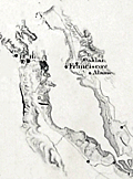 | Details | U.S. Coast and Geodetic Survey | 1869 |
| Western Coast of U.S. San Francisco to Umpquah Umpqua River |
|
U.S. Coast and Geodetic Survey |
|
| 1869 |
| LOC:68 |
| $350.00 | U-S--Coast-and-Geodetic-Survey | Western-Coast-of-U-S--San-Francisco-to-Umpquah-Umpqua-River | This is an finely detailed antique coastal nautical chart of the <b>western coast of California</b>, which focuses on the Pacific coastline between <b>San Francisco, California</b> and the Umpqua River, Oregon. It is a scarce, rolled, separately issued chart, corrected to 1869, and was first published by the U.S. Coast Survey in 1854. Notable habitations and geographical features on the chart include Empire City, Koos Bay, and Port Orford or Ewing Harbor, Oregon, as well as Crescent City, Reddings Rock, Eureka, Mendocino City, Haven's Anchorage, Bodega Bay, Pt. Reyes, Alcatraz Island, Oakland, Alameda, Union City, and San Francisco Bay, California. The chart identifies numerous soundings, navigational hazards, and aids to navigation.
<br></br>
This antique sea chart features twelve detailed <b>inset coastal elevation views</b>, including the Entrance to San Francisco Bay, Point Arena, Mendocino City Cove, Trinidad Head and City, Cape Mendocino, Red Bluff Entrance to Humboldt Bay, Point St. George, Mack's Arch and Reef, Rogues River, Cape Blanco, Cape Gregory, and Point Reyes. It is a scarce, separately issued, rolled nautical chart of the U.S. West Coast, not the more common folded version on thin paper that was issued with other charts in an annual report to Congress from the Coast Survey.
<br></br>
The chart was printed in 1869 from an electrotype-printed copy of the original hand-engraved copper plate. The U.S. Coast Survey adopted electrotype printing around 1850 because copper plates, being a soft medium, could only withstand print runs of about 200 copies before the plates wore down. To allow for larger print runs, a mold of the original plate was created in wax or another soft medium. Then, using an electro-chemical process (electrotyping), the mold was coated with a metal layer, usually copper. Printers were then able to produce output from the new electrotype copper copy while preserving the original. Electrotype copy no. 6 was done by Mathiot. |
| 4926 | 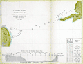 | Details | U.S. Coast and Geodetic Survey | 1872 |
| Antique chart of the Yucatan Channel Mexico Cuba |
|
U.S. Coast and Geodetic Survey |
|
| 1872 |
| LOC:13 |
| $240.00 | U-S--Coast-and-Geodetic-Survey | Antique-chart-of-the-Yucatan-Channel-Mexico-Cuba | Scarce U.S. Coast and Geodetic Survey hydrographic chart of the Yucatan Channel with soundings from 1872 taken by R. Platt then an Acting Master in the U.S.N.
<br /><br />
Old survey chart of the channel between the east Yucatan area of Mexico and the Cape San Antonio Light in Cuba. Inset drawing of the profile of the channel with a horizontal scale of 1 / 100,000. With a tabular display of the type of bottom composition (sand, mud …) encountered by depth of the soundings. |
| 3627 |  | Details | U.S. Coast and Geodetic Survey | 1873 |
| Antique Chart of Trinidad Harbor, California Humboldt County |
|
U.S. Coast and Geodetic Survey |
|
| 1873 |
| LOC:10 |
| $200.00 | U-S--Coast-and-Geodetic-Survey | Antique-Chart-of-Trinidad-Harbor--California-Humboldt-County | Rare harbor chart of Trinidad Harbor, in Humboldt County, California. With an attractive coastal elevation view of Trinidad Head, Prisoner's Rock and the entrance to the harbor as seen from offshore. Contains sailing directions, tide tables, notes and more. We are unable to find this item online or on AMPR!
<br></br>
Manuscript notations and ink stamp by the U.S. Geological Survey are unusual and point to the authenticity and age of this chart. |
| 663 |  | Details | U.S. Coast and Geodetic Survey | 1874 |
| The Harbor of Annapolis |
|
U.S. Coast and Geodetic Survey |
|
| 1874 |
| LOC:53 |
| $0.00 | U-S--Coast-and-Geodetic-Survey | The-Harbor-of-Annapolis | SOLD
<br></br>Fine original electrotype copperplate engraved nautical chart of Annapolis, Maryland and vicinity first published in 1846. On strong, thick paper with no folds. Coverage extends from Forked Creek and the Narrows at the North past Annapolis and terminates near Oyster Creek and the modern community of "Arundel on the Bay". Numerous soundings, lighthouses, buoys, and navigational hazards are noted. Electrotype copy no. 3 by G. Mathiot U.S.C.S.
<br></br>
Key named features include the Severn River, Kent Island, Greensberry's Neck, Annapolis, Fort Nonsense, Fort Madison, Mount Misery, Sullivan's Cove, Round Bay, Mt. Pleasant, St. Helena Island, Weem's Creek, Graveyard Creek, St. John's College, Spa Creek, Windmill Point, Horn Point, Cat Hole Creek, Black Walnut Creek, Thomas' Point, Price's Point, Whitehall Poplars, Whitehall Creek, Goose Pond, Sandy Point.
<br></br>
With sailing directions, tidal notes, and four attractive inset coastal profile panoramic views of the approaches to Annapolis featuring the state house as the primary point of reference.
<br></br>
This chart was printed in 1874 from an electrotype copy of the original hand-engraved copper plate, a process the U.S. Coast Survey adopted around 1850. As a soft medium, copper plates could only withstand print runs of perhaps 200 copies before the plates wore down. To enable larger print runs, a mold of the original plate was created in wax or another soft medium. Then, using an electro-chemical process ( electrotyping ), the mold was coated with a metal layer, typically copper. Printers were then able to produce output from the new electrotype copper copy, while preserving the original.
<br><br/>
This antique chart should not be confused with those similar copies issued as part of an annual Report to Congress, most on thin paper with folds that often show condition issues. With the circular stamp of the U.S. Coast Survey Depot. Number 385. |
| 3626 |  | Details | U.S. Coast and Geodetic Survey | 1875 |
| Early charts of ports on Adak and Amchitka in Aleutian Islands, Alaska |
|
U.S. Coast and Geodetic Survey |
|
| 1875 |
| LOC:0 |
| $0.00 | U-S--Coast-and-Geodetic-Survey | Early-charts-of-ports-on-Adak-and-Amchitka-in-Aleutian-Islands--Alaska | SOLD
<br></br>Interesting original US Coast Survey charts of harbors on two islands in Alaska, Adak and Amchitka, way out in the Bering Sea near the end of the Aleutian Island chain. Reason for publishing this scarce chart is likely because each harbor contains an indicated Astronomical Station.
<br></br>
Manuscript marginal notations in blue wax pencil. Rare to find old Coast Survey charts of this remote an area on such heavy paper. Chart is believed to be a file copy. |
| 520 |  | Details | U.S. Coast and Geodetic Survey | 1877 |
| Entrance to San Francisco Bay California |
|
U.S. Coast and Geodetic Survey |
|
| 1877 |
| LOC:0 |
| $0.00 | U-S--Coast-and-Geodetic-Survey | Entrance-to-San-Francisco-Bay-California | SOLD
<BR> </BR>
Stunning, large, antique rolled chart of San Francisco Bay on heavy paper. Coverage includes San Francisco and surrounding area as it existed in 1859, reprinted in 1881 with corrections to the aids to navigation. Very good condition. Bottom of chart contains two views of the entrance to the bay from the south and the north showing both steam and sail-powered vessels underway and at anchor. Noted points of interest include Oakland, Sausalito, Alcatraz Island, Yerba Buena Island, the Presidio, Mission de Delores, Table Mountain, San Leandro, Brooklyn, Alameda, and of course the Golden Gate (no bridge).<BR> </BR>
Produced under the supervision of A.D. Bache, Superintendent of the U.S. Coast Survey. Electrotype copy 3. |
| 861 | 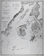 | Details | U.S. Coast and Geodetic Survey | 1880 |
| Antique Nautical Chart of Penobscot Bay with Camden and Rockport, Maine |
|
U.S. Coast and Geodetic Survey |
|
| 1880 |
| LOC:0 |
| $0.00 | U-S--Coast-and-Geodetic-Survey | Antique-Nautical-Chart-of-Penobscot-Bay-with-Camden-and-Rockport--Maine | SOLD<br></br>
Antique hydrographical chart of Penobscot Bay in Maine by the U.S. Coast and Geodetic Survey published in 1880. This 19th century chart "is the first complete chart of Penobscot Bay published by the U.S. Government". (Penobscot Maritime Museum, "Penobscot Bay Chart 1880", Internet. Accessed 7/21/2015.) Although it was published 4 years earlier by the USCS, chart number 293 only contains the central part of the bay.
<br></br>
This old nautical chart covers an area in the State of Maine including West Penobscot Bay, East Penobscot Bay, Isle au Haut Bay, Deer Isle, Vinalhaven Island, Cape Rozier, and South Long Island. Towns in Maine that are covered by the chart include Rockland, Belfast, Searsport, Stockton, Rockport, Camden, and Castine
<br></br>
This old chart was made less than 20 years after the end of the U.S. Civil War and contains thousands of details including numerous islands, depth soundings, aids to navigation, and navigation hazards.
<br></br>
Printed by the electrotype method which was adopted by the Coast Survey in the mid-1800's to support increased production volumes with high quality charts very similar to a hand-engraved copper plate engraving. Electrotype copy number 3. Scale 1/80,000. |
| 4927 |  | Details | U.S. Coast and Geodetic Survey | 1880 |
| Scarce antique Chart of Monterey Harbor California |
|
U.S. Coast and Geodetic Survey |
|
| 1880 |
| LOC:63 |
| $750.00 | U-S--Coast-and-Geodetic-Survey | Scarce-antique-Chart-of-Monterey-Harbor-California | Electrotype copy of the chart of Monterey Harbor with a fine engraved coastal elevation view of Point Pinos from 5 miles seaward. Includes sailing directions. Chart number 5491. First issued 1852 but ca. 1880.
<br></br>
This is a scarce, separately issued, rolled hydrographic chart of the California coast, first published in 1852, not one of the common folded versions on thin paper that were issued with other charts in an annual report to Congress from the Coast Survey.
<br></br>
This antique chart was printed from an electrotype copy of the original hand-engraved copper plate, a process the U.S. Coast Survey adopted around 1850. As a soft medium, copper plates could only withstand print runs of perhaps 200 copies before the plates wore down. To enable larger print runs, a mold of the original plate was created in wax or another soft medium. Then, using an electro-chemical process ( electrotyping ), the mold was coated with a metal layer, typically copper. Printers were then able to produce output from the new electrotype copper copy, while preserving the original.
<br></br>
Electrotype copy no. 3. Sheet size 27"x24". Logo of the Coast Survey Office. Price when issued 15 cents. |
| 1035 |  | Details | U.S. Coast and Geodetic Survey | 1881 |
| Narragansett Bay |
|
U.S. Coast and Geodetic Survey |
|
| 1881 |
| LOC:0 |
| $0.00 | U-S--Coast-and-Geodetic-Survey | Narragansett-Bay | SOLD<br></br>
Large, antique rolled nautical chart of Narragansett Bay on heavy paper. Includes the surrounding bays, rivers, and islands of Connecticut, Massachusetts, and Rhode Island. This scarce, detailed chart is comprised of two conjoined sheets. Price has been adjusted for known condition issue.
<BR> </BR>
First produced in 1873, this chart was reprinted in 1881 with corrections to the aids to navigation. Contains great detail of topographic and hydrographic features with hundreds of soundings and numerous aids to navigation. The chart is finely engraved and will display beautifully.
<BR> </BR>
Noted points of interest include Providence, Fall River, Bristol, Warren, Newport, Wickford, East Greenwich, Apponaug, and the Old Colony and Newport RR. At bottom of the chart is a profile view of Narragansett Bay, Beavertail Light bearing N by E. With the circular stamp of the United States Coast and Geodetic Survey. Electrotype copy No. 2. Price 75 cents when issued. |
| 521 |  | Details | U.S. Coast and Geodetic Survey | 1881 |
| Narragansett Bay from a Trigonometrical Survey |
|
U.S. Coast and Geodetic Survey |
|
| 1881 |
| LOC:0 |
| $0.00 | U-S--Coast-and-Geodetic-Survey | Narragansett-Bay-from-a-Trigonometrical-Survey |
SOLD, but see another <a href="http://www.rarecharts.com/ShowDetail/Creator/U-S--Coast-and-Geodetic-Survey/Title/Antique-chart-of-Cuttyhunk-to-Block-Island-with-Narragansett-Bay/980"_blank">similar item</a> |
| 731 |  | Details | U.S. Coast and Geodetic Survey | 1881 |
| Entrance to San Francisco Bay California 1877 |
|
U.S. Coast and Geodetic Survey |
|
| 1881 |
| LOC:0 |
| $0.00 | U-S--Coast-and-Geodetic-Survey | Entrance-to-San-Francisco-Bay-California-1877 | SOLD<BR> </BR>
Superb, large, antique U.S. Coast Survey chart of San Francisco Bay, the city of San Francisco, and lower Marin County, California on heavy paper. Shows numerous soundings and aids to navigation including Fort Point Light, Point Bonita Light, Yerba Buena Light, and Alcatraz Light.
<BR> </BR>
Coverage includes San Francisco and Sausalito and the surrounding areas as existed in 1859. This chart was reissued in October 1877 with corrections to the aids to navigation made in 1881. Very good condition. Bottom of chart contains two views of the entrance to the bay from the south and the north showing both steam and sail-powered vessels underway and at anchor. Named points of interest include the Presidio, Oakland, Cliff House, Ocean House, Sausalito, Alcatraz Island, Mission Bay, San Leandro, Yerba Buena Island, Mission de Delores, Table Mountain, Brooklyn, Alameda, and of course the Golden Gate (with no bridge).
<BR> </BR>
This antique chart should not be confused with those similar copies issued as part of an annual Report to Congress, most on thin paper with folds that often show condition issues. This issue is very large, rolled, and on heavy paper with no folds. With the circular stamp of the U.S. Coast Survey. Produced under the supervision of A.D. Bache, Superintendent of the U.S. Coast Survey first published in 1859. Electrotype copy 3. |
| 559 |  | Details | U.S. Coast and Geodetic Survey | 1883 |
| Pacific Coast Pilot Alaska Part I |
|
U.S. Coast and Geodetic Survey |
|
| 1883 |
| LOC:0 |
| $495.00 | U-S--Coast-and-Geodetic-Survey | Pacific-Coast-Pilot-Alaska-Part-I | U.S. Coast Pilot of a portion of the Alaskan coast c 1883. An increasingly scarce late 19th century volume. With 16 folding lithographed charts and 13 folding sheets of views on thin onion-skin type paper all in excellent nearly pristine condition. Total of 331 pages includes over 200 pages of detailed sailing directions, several indexes, notes on name pronunciation, meteorological tables and sailing distances. <br><br/>
Manuscript fly page inscription dated July 22, 1887 by Edwin H. Abbot, Milwaukee, Wis. Original half leather with marbled boards and gold embossed spine. Boards cleanly detached but still present. U.S. Coast and Geodetic Survey. J.E. Hilgard, Superintendent. Washington 1883. |
| 5458 | 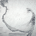 | Details | U.S. Coast and Geodetic Survey | 1885 |
| Original antique nautical chart Cape Cod Bay and Provincetown Massachusetts |
|
U.S. Coast and Geodetic Survey |
|
| 1885 |
| LOC:1403 |
| $850.00 | U-S--Coast-and-Geodetic-Survey | Original-antique-nautical-chart-Cape-Cod-Bay-and-Provincetown-Massachusetts | Original rolled, antique U.S. Coast Survey Chart no. 10 of Cape Cod Bay with the Cape Cod Peninsula first published in 1872. Numerous locations from Duxbury to Pochet Island and aids to navigation are highlighted and/or annotated in manuscript pen and ink (e.g. Nauset Beach Beacons, Wood End Light) Includes Provincetown and Provincetown Harbor. Three inset coastal recognition views as seen from offshore.
<br></br>
This is a scarce, separately issued, rolled hydrographic chart of the Massachusetts Coast from 1872, not one of the common folded versions on thin paper from annual report of the U.S. Coast Survey to Congress. This edition issued 1880 by C.P. Patterson. Updates to aids-to-navigation date the print to 1885. The price of this chart when first issued was 40 cents. Electrotype copy #2 [1].
<br></br>
[1] Artifact of the electrotype reprographic technique to create a intaglio copy of the original hand-engraved copper plate, a process the U.S. Coast Survey adopted around 1850. As a soft medium, copper plates could only withstand print runs of perhaps 200 copies before the plates wore down. To enable larger print runs, a mold of the original plate was created in wax or another soft medium. Then, using an electro-chemical process ( electrotyping ), the mold was coated with a metal layer, typically copper. Printers were then able to produce intaglio output from the new electrotype copper copy, while preserving the original hand-engraved plate.
<br></br>
Logo. |
| 980 | 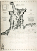 | Details | U.S. Coast and Geodetic Survey | 1887 |
| Antique chart of Cuttyhunk to Block Island with Narragansett Bay |
|
U.S. Coast and Geodetic Survey |
|
| 1887 |
| LOC:53 |
| $1,250.00 | U-S--Coast-and-Geodetic-Survey | Antique-chart-of-Cuttyhunk-to-Block-Island-with-Narragansett-Bay | Large, original, antique nautical chart of the New England coast (1887) including Narragansett Bay. Superb condition. Coverage includes the northern tip of Block Island and extends from Perrysville/Point Judith/Wakefield westward to past the <b>Hen and Chickens light vessel</b> and <b>Cuttyhunk Lighthouse</b>. This original navigation chart includes the surrounding bays, rivers, and islands of Connecticut, Massachusetts, and <b>Rhode Island</b>. Manuscript notations in ink on the verso indicate this chart was one of two purchased in 1887 for the ship "Asia". The old maritime chart shows fine detail and will display beautifully.
<BR> </BR>
Key geographic features include Fall River, Sakonnet River, Conanicut Island, East Tern Passage, and Mt. Hope Bay. Noted points of interest include Providence, Bristol, Warren, Newport, Wickford, East Greenwich, Apponaug, the Old Colony and Newport RR, and Brenton's Reef Light Vessel. Contains a table of lighthouses and a tide table as well as notations about lightships, soundings, and bottom abbreviations.
<BR> </BR>
First produced by the U.S. Coast and Geodetic Survey in 1876, this chart was reprinted in 1887 with corrections to the aids to navigation. Contains great detail of topographic and hydrographic features with hundreds of soundings and numerous aids to navigation.
<BR> </BR>
With the circular logo of the United States Coast and Geodetic Survey. Chart number 113. Electrotype copy No. 9. Price 40 cents when issued. |
| 3630 | 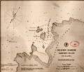 | Details | U.S. Coast and Geodetic Survey | 1888 |
| Early chart of St. John Harbor, Zarembo Island, Alaska |
|
U.S. Coast and Geodetic Survey |
|
| 1888 |
| LOC:10 |
| $300.00 | U-S--Coast-and-Geodetic-Survey | Early-chart-of-St--John-Harbor--Zarembo-Island--Alaska | Early chart of St. John Harbor on Zarembo Island in S.E. Alaska. Printed by the U.S. Coast and Geodetic Survey as a separately issued harbor chart for a price of 15 cents at the time.
<br></br>
Zarembo Island is an island in the Alexander Archipelago of southeastern Alaska, United States. It lies directly south of Mitkof Island and northwest of Etolin Island.
<br></br>
Rare to find old Coast Survey charts of this remote an area on such heavy paper. With red stamp of the U.S. Geological Survey library. Chart is believed to have been an institutional file copy. |
| 3590 | 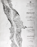 | Details | U.S. Coast and Geodetic Survey | 1888 |
| Chart of Columbia River with Washington Oregon Kalama |
|
U.S. Coast and Geodetic Survey |
|
| 1888 |
| LOC:63 |
| $350.00 | U-S--Coast-and-Geodetic-Survey | Chart-of-Columbia-River-with-Washington-Oregon-Kalama | Rolled chart of the Columbia River from Kalama to Fales Landing. Includes portions of both Oregon and Washington states; St. Helen, Columbia City. With tables of authorities, buoys, river lights, abbreviations. Sheet number 5 of the series. Individually published and priced. Heavy paper consistent with the expected use for navigation onboard river vessels.
<br></br>
No mention of the use of the electrotype process. Presumed printed with original plate.
<br></br>
With the circular logo of the United States Coast and Geodetic Survey. Scale 1/40,000. Chart number 641. Issued May 1888. Price when issued: 25 cents. |
| 3589 | 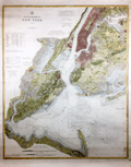 | Details | U.S. Coast and Geodetic Survey | 1889 |
| Huge antique chart of New York Bay and Harbor |
|
U.S. Coast and Geodetic Survey |
|
| 1889 |
| LOC:1401 |
| $3,250.00 | U-S--Coast-and-Geodetic-Survey | Huge-antique-chart-of-New-York-Bay-and-Harbor | A spectacular, large (48" high) antique nautical chart of New York Bay and Harbor from 1889. Beautiful hand coloring enhances the attractiveness of this scarce and fine engraving. Two sheets professionally joined.
<br></br>
This chart was printed in 1889 from an electrotype copy of the original hand-engraved copper plate, a process the U.S. Coast Survey adopted around 1850. As a soft medium, copper plates could only withstand print runs of perhaps 200 copies before the plates wore down. To enable larger print runs, a mold of the original plate was created in wax or another soft medium. Then, using an electro-chemical process ( electrotyping ), the mold was coated with a metal layer, typically copper. Printers were then able to produce output from the new electrotype copper copy, while preserving the original. Electrotype copy number 3.
<br></br>
With the circular logo of the United States Coast and Geodetic Survey. Tables of lighthouses and lightships. Two inset coastal elevation views. Scale 1/40,000. Chart number 369. Published August, 1889. Plate number 1987. Price when issued: 75 cents. |
| 6757 | 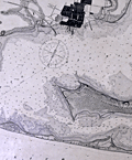 | Details | U.S. Coast and Geodetic Survey | 1892 |
| Scarce original antique nautical chart of Pensacola, Florida |
|
U.S. Coast and Geodetic Survey |
|
| 1892 |
| LOC:11111 |
| $0.00 | U-S--Coast-and-Geodetic-Survey | Scarce-original-antique-nautical-chart-of-Pensacola--Florida | SOLD<br><br>Quite scarce original nautical chart of the entrance to Pensacola Harbor, Florida. The map was first published by the United States Coast and Geodetic Survey (U.S.C.G.S.) in 1859 but this updated edition dates from May, 1892. The map shows Big Lagoon, ruins of Fort McRee, Fort Pickens on Santa Rosa Island, Woolsey, Warrington, and English Navy Cove. Pensacola is depicted laid out in a grid pattern while the entire tip of Fairpoint Peninsula including Gulf Breeze is shown forested as "United States Live Oak Plantations".
<br><br>
Rare. Over the last decade a resurgent interest in nautical charts and in Floridiana has made this chart increasingly difficult to obtain. 31" x 25" inside the neatlines.
<br><br>
Price of this chart when issued was 25 cents. Electrotype Copy No. 5. (1) U.S.C.G.S. Chart No. 490.
<br><br>
(1) Electrotyping is a reprographic printmaking method that was especially important in the 19th century, as it allowed for high-quality, high-volume reproduction of texts and images. Electrotype printing involves creating a metal plate via electroplating for printing. The process starts by forming a mold of the original work with a soft material like wax. This mold is dusted with graphite powder for conductivity, then submerged in a copper sulfate solution. An electric current is applied, causing copper ions to deposit onto the mold. The process continues until a sufficient copper layer forms. The new copper shell or 'electrotype' is separated from the mold and its back is filled with a type metal like lead for strength.
<br><br>
After cooling, the electrotype is finished and trimmed for use. It is inked and pressed against paper to produce prints of the original plate. This process was significant in the 19th century for high-quality, high-volume reproduction. |
| 4804 | 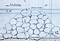 | Details | U.S. Coast and Geodetic Survey | 1894 |
| Antique MS engineering drawing of screw-pile day-mark beacon |
|
U.S. Coast and Geodetic Survey |
|
| 1894 |
| LOC:55 |
| $450.00 | U-S--Coast-and-Geodetic-Survey | Antique-MS-engineering-drawing-of-screw-pile-day-mark-beacon | Fine late 19th-century manuscript engineering drawings of a screw-pile day-beacon designed for the Tobago Middle Ground shoal in the Rappahannock River, Virginia. Probably a product of the U.S. Coast and Geodetic Survey. Dated within to 1894. Baltimore, Maryland.
<br></br>
Manuscript pencil notations: "Not used" and "Historical".
<br></br>
In a 1896 letter to Congress transmitting estimates of appropriations from the Secretary of the Treasury is a line item for $3,000 for "Establishing a day beacon on or near the Tobago Middle Ground, Rappahannock River, Virginia." A note below the item states: "The middle ground has but four feet of water on it. A prominent mark would be a valuable aid in the navigation of that part of the river." Apparently this request derived from the Lighthouse Board who proposed to build a screw-pile beacon at Tobago as early as 1893.
<br></br>
Our drawing, from 1894, is annotated with the words "not used". That may very well be because a less expensive solution was adopted. According to the U.S. Coast and Geodetic Survey Notice to Mariners in 1903 "a black spar buoy, without number, was placed in 15 feet of water on the edge of the shoal opposite the upper end of Tobago Middle Ground." |
| 5281 | 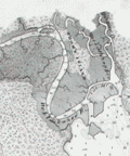 | Details | U.S. Coast and Geodetic Survey | 1900 |
| Scarce nautical chart Apalachee Bay to St. Georges Sound Florida |
|
U.S. Coast and Geodetic Survey |
|
| 1900 |
| LOC:1403 |
| $0.00 | U-S--Coast-and-Geodetic-Survey | Scarce-nautical-chart-Apalachee-Bay-to-St--Georges-Sound-Florida | Sold
<br></br>
Scarce, very large antique rolled nautical chart of the northern Florida coast from Apalachee Bay to St. Georges Sound, Florida. Published by the U.S. Coast and Geodetic Survey. Date of first publication 1883 but this electrotype edition is updated with corrections to 1900. Notable features include Ocklockonee Bay, St. James Island, Oyster Bay, St. Marks and Port Leon, Florida.
<br></br>
Not a preliminary chart. Full-size antique nautical charts on heavy paper of Apalachee Bay are very scarce, whether by the U.S. Coast Survey or by any other publisher
<br></br>
Chart number 182. Price when issued 50 cents. J.E. Hilgard, (Washington, DC: United States Coast and Geodetic Survey, 1883)
<br></br>
This antique chart of the north Florida coast was printed in 1900 from an electrotype copy of the original hand-engraved copper plate, a process the U.S. Coast Survey first adopted around 1850. As a soft medium, copper plates could only withstand print runs of perhaps 200 copies before the plates wore down. To enable larger print runs, a mold of the original plate was created in wax or another soft medium. Then, using an electro-chemical process ( electrotyping ), the mold was coated with a metal layer, typically copper. Printers were then able to produce output from the new electrotype copper copy, while preserving the original. Electrotype copy no. 1. |
| 689 | 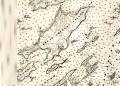 | Details | U.S. Coast and Geodetic Survey | 1901 |
| Casco Bay, Maine |
|
U.S. Coast and Geodetic Survey |
|
| 1901 |
| LOC:0 |
| $0.00 | U-S--Coast-and-Geodetic-Survey | Casco-Bay---Maine | SOLD.
<br></br>
Original old, rolled antique sea chart of the inside passages for Casco, Bay Maine that has seen usage afloat based on the light pencil course plot lines. This large old navigation chart on heavy paper, first published in 1870 by the U.S. Coast and Geodetic Survey, carries the patina of age while retaining almost all its original beauty. Numerous lights and aids to navigation are captured along with a host of nautical hazards: Temple's Ledge, Ram Island Ledge, Halibut Rocks, Dick's Shoal, Sisters Ground, and many more. Lots of opportunity to run aground… or worse.
<br></br>
Coverage includes the geographical features of Cape Elizabeth, Peak's Island, Cushing Island, Luckse's Sound, Presumpscot River, Fort Gorges, Fort Preble, Fort Scammel, Portland Head Light, Whaleboat Island, Great Chebeague Island, Quahog Bay, Crotch Island, Cape Small, Maquoit Bay, Bald Head, Sebascodegan Island, Harpswell Neck, New Meadows River. Population centers include: Portland, Maine, Falmouth Corner, Yarmouth, Freeport Landing, and South Freeport. Chart number 315.
<br></br>
This chart (Electrotype copy No. 2) was printed on or after 1901 from an electrotype plate of the original hand-engraved copper plate, a process the U.S. Coast Survey adopted around 1850. As a soft medium, copper plates could only withstand print runs of perhaps 200 copies before the plates wore down. To enable larger print runs, a mold of the original plate was created in wax or another soft medium. Then, using an electro-chemical process ( electrotyping ), the mold was coated with a metal layer, typically copper. Printers were then able to produce output from the new electrotype copper copy, while preserving the original. |
| 706 | 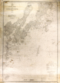 | Details | U.S. Coast and Geodetic Survey | 1902 |
| St. George River and Muscle Ridge Channel, Maine |
|
U.S. Coast and Geodetic Survey |
|
| 1902 |
| LOC:0 |
| $225.00 | U-S--Coast-and-Geodetic-Survey | St--George-River-and-Muscle-Ridge-Channel--Maine | Antique nautical chart issued in 1902 covers from Thomaston, Maine southwestward along the St. George River past St. George, Maine and Tennant Harbor, the Marshall Point Lighthouse to Burnt Island and from a line drawn through those areas to the east, covering the island-strewn Maine Atlantic coast. Coastal areas covered by this old sea chart encompass Two Bush Channel and these islands: Rackliff's, Andrew's, Hewell's, Hooper's, Metlinik, Ash, Sheep, Grafton, Pleasant, Sprucehead, Whitehead, Munroe, and Alleni Islands.
</br>
Other points of interest noted on this old chart include South Thomaston, Friendship and Port Clyde, Maine; Fort St. George, Maple Juice Cove, Hart's Neck, Mosquito Head, Cutter's Nubble, Old Woman Ledge, Owl's Head Light, and Fog's Hill.
<br></br>
Date of first publication was 1873. This antique chart bears a stamp at the bottom in purple ink that identifies this edition as later: "Aids to navigation corrected with information received Jul 13, 1902."
<br></br>
This chart was printed from an electrotype copy of the original hand-engraved copper plate, a process the U.S. Coast Survey adopted around 1850. As a soft medium, copper plates could only withstand print runs of perhaps 200 copies before the plates wore down. To enable larger print runs, a mold of the original plate was created in wax or another soft medium. Then, using an electro-chemical process ( electrotyping ), the mold was coated with a metal layer, typically copper. Printers were then able to produce output from the new electrotype copper copy, while preserving the original. This print run is electrotype copy number 2. Chart number 312. Price when issued 25 cents. |
| 694 | 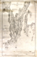 | Details | U.S. Coast and Geodetic Survey | 1902 |
| Kennebec and Sheepscot Rivers, Maine |
|
U.S. Coast and Geodetic Survey |
|
| 1902 |
| LOC:0 |
| $165.00 | U-S--Coast-and-Geodetic-Survey | Kennebec-and-Sheepscot-Rivers--Maine | Large, rolled, antique nautical chart of the southern reaches of the Kennebec and Sheepscot Rivers in Maine first issued in 1868 with corrections to 1902. This old chart covers the numerous bays, coves, and idyllic islands that dot the coast to the south and to the east of Bath, Maine.
<br></br>
Two interesting features add value to the chart. The first is a location defined as "Ancient Augusta 1717 - 1721" but near the mouth of Cape Small Harbor well south of present-day Augusta, Maine. The second interesting feature, identified as "Ancient Fort George", lies directly to the west of Fort Popham, in the area of Sabino Head. That reference to Fort George is apparently Fort St. George, part of a very early English colonial settlement of Popham recently 'rediscovered' in 1994. The colony (also called the Sagadahoc Colony) was founded in 1607, 13 years before the Plymouth Colony and it has been called "the cornerstone in the foundation of English America". ( Reference: www.smithsonianmag.com/history/maines-lost-colony-106323660/?no-ist=&page=1 )
<br></br>
Geographical features include: Merry Meeting Bay, Georgetown Island, Linekins Bay, Montseag Bay, Southport Island, Seguin Island, Hockomock Bay, Mount Pisgah, and Robin Hood Cove. Noted population centers include: Bath, Woolwich, Winnegance, Drummore Mills, Phillipsburg Center, Parker's Head Village, Wicasset, and Boothbay Harbor, Maine. Bottom of chart contains 3 inset profile coastal views of various approaches to the Kennebec River.
<br></br>
On heavy paper, this chart (Electrotype copy No. 3) was printed on or after 1902 from an electrotype plate of the original hand-engraved copper plate, a process the U.S. Coast Survey adopted around 1850. Numerous soundings, aids to navigation and hazards are noted. Rubber stamp imprint at bottom reads: "Aids to navigation correct from information received to Aug 4 1902." Number 314. |
| 557 | 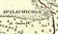 | Details | U.S. Coast and Geodetic Survey | 1914 |
| 1914 Inside Route Pilot Key West to New Orleans |
|
U.S. Coast and Geodetic Survey |
|
| 1914 |
| LOC:2001 |
| $400.00 | U-S--Coast-and-Geodetic-Survey | 1914-Inside-Route-Pilot-Key-West-to-New-Orleans | Very scarce, intact 1914 Coast Pilot with six strip charts and sailing directions for what is now the Gulf Intracoastal Waterway, from Key West, Florida heading north and then west to New Orleans, Louisiana. Published by the U.S. Coast and Geodetic Survey. Contains 93 pages of text plus an index.
<br><br/>
In its early history some portions of the 'inside route' were owned and dredged by private entities who charged a toll to vessels for passage, sometimes by stringing a chain across narrow passages to restrict traffic flow. After 1919 Congress mandated that the entire passage should be turned over to the Federal government and the tolls were eliminated.
<br><br/>
The sailing directions for Bayou St. John describe a moment in time that New Orleans residents can only imagine today: <dir class="indenttextblock">The channel at the entrance is protected by training walls on each side. Spanish Fort is a pleasure resort at the mouth of Bayou St. John and is connected with New Orleans by an electric car line... Small craft of all kinds use the bayou as far as Esplanade Street, about 2 3/4 miles above the entrance, but pleasure boats rarely go above that point." </dir>
Size of each chart when folded is approximately 8" x 5". The pilot's lithographed working navigational charts capture the full extent of the southern U.S. Inside Route in detail. Chart sections include roughly these areas and chart sizes: (fully opened, height is 10" and width is listed below). <br>
1. Key West to Matanzas Pass - 24"<br>
2. Matanzas Pass to Clearwater - 23"<br>
3. Clearwater to Tampa - 27"<br>
4. Tampa to St. Andrews Sound - 24"<br>
5. St. Andrews Sound to Bay St. Louis - 36"<br>
6. Bay St. Louis to New Orleans. - 23"<br>
<br><br/>
If they were placed end to end, the charts would extend over 13 feet long. Original price 20 cents. Published by the Government Printing Office in Washington DC in 1915. |
| 6361 | 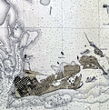 | Details | U.S. Coast and Geodetic Survey | 1914 |
| Key West Harbor 1914 |
|
U.S. Coast and Geodetic Survey |
|
| 1914 |
| LOC: |
| $1,000.00 | U-S--Coast-and-Geodetic-Survey | Key-West-Harbor-1914 | Large 42" x 34" U.S. Coast Survey chart of Key West Harbor, Florida . Issued September 1914 by the U.S. Department of Commerce / U.S. Coast Survey. Number 584. A scarce original nautical chart of Key West at 107 years old. Last date is 1914. |
| 5443 | 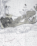 | Details | U.S. Coast and Geodetic Survey | 1914 |
| Scarce antique chart of Key West Harbor and Approaches |
|
U.S. Coast and Geodetic Survey |
|
| 1914 |
| LOC: |
| $1,440.00 | U-S--Coast-and-Geodetic-Survey | Scarce-antique-chart-of-Key-West-Harbor-and-Approaches | A scarce 107 year-old chart of Key West Harbor and its approaches in Florida. A nice example, scarce to find with process color from this era.
<br></br>
Published by the US Coast and Geodetic Survey in 1914, the chart shows Whitehead spit, east and west Martello Tower, Raccoon Key, and Stock Island. Coverage extends to the west as far as Boca Grande Key. Chart # 584. Price when issued was 50 cents. |
| 4771 | 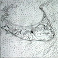 | Details | U.S. Coast and Geodetic Survey | 1916 |
| Nantucket Sound Massachusetts |
|
U.S. Coast and Geodetic Survey |
|
| 1916 |
| LOC:53 |
| $1,200.00 | U-S--Coast-and-Geodetic-Survey | Nantucket-Sound-Massachusetts | Fine antique engraved nautical chart first issued in 1915 covers the southeast portion of Cape Cod trending south and includes Hyannis Harbor, Tuckernuck Island and the islands of Nantucket, Monomoy, Chatham and eastern Nantucket Sound.
<br></br>
This bright antique chart bears a stamp at the bottom right in black ink that identifies this edition as corrected to May 29, 1916. Plate number 3446 for this 1915 ed. replaced the previous edition of 1909 which used plate number 2999. With the circular logo of the Department of Commerce and Labor. Chart number 111. |
| 301 |  | Details | U.S. Coast and Geodetic Survey | 1916 |
| 1916 Inside Route New York to Key West |
|
U.S. Coast and Geodetic Survey |
|
| 1916 |
| LOC:0 |
| $0.00 | U-S--Coast-and-Geodetic-Survey | 1916-Inside-Route-New-York-to-Key-West | <BR> </BR>
This item has been sold but please see <a
href="https://www.rarecharts.com/ShowDetail/Creator/U-S--Coast-and-Geodetic-Survey/Title/8-Charts-Inside-Route-New-York-to-Key-West-or-ICWW-1916/6553">another example, our first in eleven years.</a>
<BR> </BR>
Complete set of eight U.S. Coast and Geodetic Survey folding navigational charts for the inside route for maritime traffic on the eastern coast of the United States from New York South. These historical charts from 1916 predate the U.S. Government's ownership of the route which later became part of the Intracoastal Waterway (ICW) . Placed end to end, the charts would extend over 18 feet long. |
| 6553 |  | Details | U.S. Coast and Geodetic Survey | 1916 |
| 8 Charts Inside Route New York to Key West or ICWW 1916 |
|
U.S. Coast and Geodetic Survey |
|
| 1916 |
| LOC:300 |
| $585.00 | U-S--Coast-and-Geodetic-Survey | 8-Charts-Inside-Route-New-York-to-Key-West-or-ICWW-1916 | Very scarce and complete set of eight U.S. Coast and Geodetic Survey folding navigational charts for the inside route for maritime traffic on the eastern coast of the United States from New York South. Third edition. These historical charts from 1916 predate the U.S. Government's ownership of the route which later became part of the Intracoastal Waterway (ICWW) . Placed end to end, the charts would extend over 18 feet long.
<br><br>
Includes the 94 page Coast Survey Sailing Directions that once housed the 8 charts in an attached interior envelope. Card cover. Binding intact. Price when issued was 20 cents.
<BR> </BR>
A bit of research shows that in its early history some portions of the inside route were owned and dredged by private entities who charged a toll to vessels for passage, sometimes by stringing a chain across narrow passages to restrict traffic flow. In fact, chart 7 contains manuscript pencil annotations, obviously made during a voyage, of "Toll" and "Toll chain" that reflects that little-known fact. Interestingly, the toll chains are not noted as part of the official chart. After 1919 Congress mandated that the entire passage should be turned over to the Federal government and the tolls were eliminated.<BR> </BR>
Size of each chart when folded is approximately 8" x 5". These 8 lithographed working navigational charts capture the full extent of the eastern U.S. inside route in detail with some manuscript pencil annotations, especially in Florida. Chart sections include roughly these areas and chart sizes: (one dimension is typically 10" and the other dimension is below). <BR>
1. Jersey City to Philadelphia - 10" <BR>
2. Philadelphia to Norfolk - 33" <BR>
3. Norfolk to Cape Lookout - 28" <BR>
4. Cape Lookout to Murphy Island - 31" <BR>
5. Murphy Island to Fernandina - 35" <BR>
6. Fernandina to Cape Canaveral -28" <BR>
7. Cape Canaveral to Miami -32" <BR>
8. Miami to Key West - 24" <BR> |
| 713 |  | Details | U.S. Coast and Geodetic Survey | 1918 |
| Mississippi River from the Passes to Grand Prairie Louisiana |
|
U.S. Coast and Geodetic Survey |
|
| 1918 |
| LOC:0 |
| $135.00 | U-S--Coast-and-Geodetic-Survey | Mississippi-River-from-the-Passes-to-Grand-Prairie--Louisiana | Large colorful early 20th century navigation chart of the Mississippi River Delta with the passes into the Gulf of Mexico. Coverage includes the area south of Point Pleasant and Metcalf, Louisiana and Tropical Bend with Breton Island, the Bird Islands, Main Pass, Octave Pass, Baptiste Collett's Bayou, Raphael Pass, and Southwest Pass. Includes Fort Jackson and on the opposite bank- Fort St. Philip. The most southerly habitation shown is Buras, Louisiana and it appears in those days the road ended there.
<br></br>
It is striking in comparing this old map to modern charts to see how much marsh land has been replaced with open water in less that 100 years.
<br</br>
Based on surveys from 1859 to 1918.Bears a blue ink stamp in the bottom margin that states the chart was issued based on corrections made in December 1918. Plate 3614. Number 94. |
| 779 |  | Details | U.S. Coast and Geodetic Survey | 1919 |
| Cape Hatteras Outer Banks North Carolina |
|
U.S. Coast and Geodetic Survey |
|
| 1919 |
| LOC:0 |
| $0.00 | U-S--Coast-and-Geodetic-Survey | Cape-Hatteras-Outer-Banks-North-Carolina | SOLD<br></br>
Old U.S. nautical chart of Cape Hatteras, and the outer banks in North Carolina. This 96-year old large two-color navigation chart of the barrier islands near Cape Hatteras includes Portsmouth Island, Ocracoke Island, Gull Island, Hatteras Inlet, Ocracoke Inlet, Sandy Bay, and the towns of Portsmouth, Ocracoke, Hatteras, Buxton, and Kinnakeet ( Avon ). On the mainland side of the sound coverage includes the vicinity of Wyesocking ( Wysocking ) Bay, with small towns of Nebraska and Middleton, and also the Middleton Anchorage.
<br></br>
Detailed delineation of lights, buoys, and soundings and emphasis on the numerous reefs and shoals both inside and outside the Hatteras barrier islands. These features include Diamond Shoal, Wimble Shoals, Clam Shoal, Long Shoal, Oliver Reef, Clarks Reef, and dozens more. This area has become known as the 'Graveyard of the Atlantic' because more than 600 ships have sunk in the waters since 1526. The schooner Carrol A. Deering, discussed elsewhere on this site, went aground a few miles from the Cape Hatteras lighthouse in 1921.
<br></br>
Originally published at Washington, D.C. in 1918 this edition sports a purple hand-stamp bearing the date of presumably the last corrections: November 8, 1919. Number 1232. |
| 5444 |  | Details | U.S. Coast and Geodetic Survey | 1920 |
| Chart of the St. Johns River in Florida From Hibernia to Racy Point 1900 1920 |
|
U.S. Coast and Geodetic Survey |
|
| 1920 |
| LOC:56 |
| $750.00 | U-S--Coast-and-Geodetic-Survey | Chart-of-the-St--Johns-River-in-Florida-From-Hibernia-to-Racy-Point-1900-1920 | Nautical chart of a section of the St. Johns River Florida from Hibernia southward to Racy Point. Hibernia, Florida lies about 22 miles southwest of downtown Jacksonville, on the western side of the St. Johns River, off US 17. Racy Point lies on the east bank of the St. John's River about four miles northwest of Hastings, Florida and 12 miles from Palatka.
<br></br>
Published by the U.S. Coast and Geodetic Survey October, 1900. Reissued December, 1916. Last corrections April, 1920. Chart # 455c. Price when issued was 40 cents. |
| 725 |  | Details | U.S. Coast and Geodetic Survey | 1920 |
| Inside Route Pilot Coast of New Jersey |
|
U.S. Coast and Geodetic Survey |
|
| 1920 |
| LOC:0 |
| $0.00 | U-S--Coast-and-Geodetic-Survey | Inside-Route-Pilot-Coast-of-New-Jersey | SOLD
<br></br>
Old Coast Pilot for New Jersey coast with 3 charts on the "Inside Route", part of what we would today call the Intracoastal Waterway ( ICW ). Covers the inlets and interior waterways on the coast of New Jersey between Sandy Hook and Cape May. Some of the geographic features covered include: Manasquan Inlet, Barnegat Bay, Manahawken Bay, Little Egg Inlet, Brigantine Inlet, Atlantic City, Absecon Bay, Ventnor, Great Egg Inlet, Longport, Wildwood, and Holly Beach.
<br></br>
Text sailing directions of 22 pages plus appendix and index. Three folding charts in very good conditions on thin paper. Length of the 3 charts totals 87 inches: Chart 1 - 28". Chart 2 - 31". Chart 3 - 28". Paper boards. Printed by the Government Printing Office, Washington, DC in 1920. Second Edition. Serial No. 139. |
| 5184 | 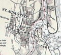 | Details | U.S. Coast and Geodetic Survey | 1929 |
| Florida Inside Route St. Augustine to Titusville |
|
U.S. Coast and Geodetic Survey |
|
| 1929 |
| LOC:61 |
| $180.00 | U-S--Coast-and-Geodetic-Survey | Florida-Inside-Route-St--Augustine-to-Titusville | Chart of a portion of what is today known generally as the Intracoastal Waterway: "Florida Inside Route St. Augustine to Titusville." South of the Matanzas Inlet, a portion of the inside route opposite Flagler Beach is labelled "Florida East Coast Canal." In the 1920's portions of the Inside Route were maintained by private entities who paid for canal maintenance by charging a toll for use of the waterway. As many as six toll stations existed in those days from Jacksonville to Hallandale, Florida.
<br></br>
First published by the U. S. Coast and Geodetic Survey, Washington D. C. in September 1928. Chart # 3258. Stamped October 17, 1929. |
| 1010 | 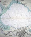 | Details | U.S. Coast and Geodetic Survey | 1946 |
| Lakes Pontchartrain and Maurepas, Louisiana |
|
U.S. Coast and Geodetic Survey |
|
| 1946 |
| LOC:0 |
| $0.00 | U-S--Coast-and-Geodetic-Survey | Lakes-Pontchartrain-and-Maurepas--Louisiana | SOLD
<br></br>
Modern 70 year-old chart of South Louisiana focused on Lake Pontchartain and New Orleans. Key features are the chart's fine unblemished condition and the absence of the Lake Ponchartrain Causeway Bridge. A series of lighted bouys extends from the south shore in Metairie to the north shore near Mandeville. Little development shown in Metairie as expected.
<BR></BR>
Published in 1943 but this edition was published with corrections in 1946. |
| 5099 | 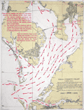 | Details | U.S. Coast and Geodetic Survey | 1951 |
| Tampa Bay Tidal Current Chart Book |
|
U.S. Coast and Geodetic Survey |
|
| 1951 |
| LOC:0 |
| $200.00 | U-S--Coast-and-Geodetic-Survey | Tampa-Bay-Tidal-Current-Chart-Book | Scarce 1951 tidal chart book on card stock with 12 (front and back) charts of Tampa Bay, Florida showing the direction and velocity of tidal flow across Tampa bay for each hour of its semi-daily tidal cycle.
<br></br>
Price when issued 35 cents; when sold 50 cents. U.S. Government Printing Office. Serial no.743. |
| 6468 |  | Details | U.S. Coast and Geodetic Survey | 1975 |
| USCGS poster for Aeronautical Charts |
|
U.S. Coast and Geodetic Survey |
|
| 1975 |
| LOC:90 |
| $0.00 | U-S--Coast-and-Geodetic-Survey | USCGS-poster-for-Aeronautical-Charts | SOLD<br><br>Surprisingly scarce poster ca 1970s, originally published in 1959, advertising aeronautical charts sold by the U.S. Coast and Geodetic Survey in Washington, D. C. A later re-issue published by the NOAA, National Ocean and Atmospheric Administration, National Ocean Service. At one time paper copies of the poster were available by order from the NOAA Distribution Branch but by 2013 products were only available in PDF or print-on-demand format.
<br><br>
A map dealer's dream meta-poster!
<br><br>
WorldCat contains only one record of the poster, at the University of Maryland. No example of the original 1959 poster are known to me.
<br><br>
Selected dates useful for dating U.S. Coast Survey charts:
<div class="indenttextblocksingle">
<ul style="list-style-type: circle;"></li>
<li>1807 - President Thomas Jefferson establishes Survey of the Coast.</li>
<li>1836 - Survey of the Coast was renamed U.S. Coast Survey. </li>
<li>1878 - U.S. Coast Survey renamed as Coast and Geodetic Survey.</li>
<li>1970 - Coast and Geodetic Survey included within the NOAA and renamed National Geodetic Survey.</li>
<li>2013 - NOAA ends printing of lithographic charts in favor of PDF.</li>
</ul>
</div> |