| | Thumbnail | | Creator | Date | Title / Author / Date / Location | Price | | | Description |
| 378 |  | Details | Jefferys, Thomas | 1759 |
| Plan of New Orleans and the Mississippi River |
|
Jefferys, Thomas |
|
| 1759 |
| LOC:0 |
| $0.00 | Jefferys--Thomas | Plan-of-New-Orleans-and-the-Mississippi-River | SOLD
<BR></BR>
Large, early foundational map for the collector of New Orleans cartography. By English cartographer Thomas Jefferys. Stunning and quite scarce plan of New Orleans, Louisiana with insets of the mouth of the Mississippi River and also a long stretch of the river from south of Donaldsonville to the passes. The map of New Orleans's French Quarter is similar to the earlier chart by <a rel="nofollow" href = "http://www.rarecharts.com/creator/Bellin--Jacques-Nicolas/" > Jacques Bellin</a> but contains additional details outside the French Quarter, which was largely marsh land at that time, including a road to Bayou St. John.<BR> </BR>
See <a rel="nofollow" href= "https://www.rarecharts.com/displaybycategory/city/new%20orleans"> other New Orleans items.</a> <BR> </BR>
Attribution and date at bottom: "Nov 1759. Published According to Act of Parliament by T. Jefferys at Charing Cross Price 2d.<BR> </BR> |
| 530 |  | Details | Jefferys, Thomas | 1761 |
| Plan of the Isle of Aix |
|
Jefferys, Thomas |
|
| 1761 |
| LOC:4 |
| $185.00 | Jefferys--Thomas | Plan-of-the-Isle-of-Aix | Plan of the island of Aix, France, off the mouth of the Charente river on the west coast of France. Depicts the village, vineyards, and fort, gun batteries, and a shipwreck at the northern end of the island. The plan shows the island as it existed after it was captured by the British in 1757 during the Seven Year's War.
<br><br/>
This plate is one of 80 maps included in Jeffery's "A Description of the Maritime Parts of France…" first published in 1761. |
| 264 |  | Details | Jefferys, Thomas | 1762 |
| Plan of the Colorado Rocks near the west end of Cuba. |
|
Jefferys, Thomas |
|
| 1762 |
| LOC:0 |
| $0.00 | Jefferys--Thomas | Plan-of-the-Colorado-Rocks-near-the-west-end-of-Cuba- | SOLD<br></br>
Antique copperplate engraved harbor chart of the barrier reef of Colorado's Archipelago on the westernmost point on the island of Cuba. This detailed chart covers the far west point of the Guanahacabibes Peninsula, Cape San Antonio and was published in 1762 by the prolific British engraver and publisher Thomas Jefferys (ca.1710-1771) in "A Description of the Spanish Islands and Settlements on the Coast of the West Indies, compiled from Authentic Memoirs, Revised by Gentlemen who have Resided Many Years in the Spanish Settlements".<br></br>
The amount and type of detail on this antique chart , lacking in many charts of this series, indicates as great familiarity with the area. Noted points of interest include an Isle of Pines (Pinos), Cape Corrientes, several watering places, a grove of date trees, and a beach with "white sands with cockle shells" near an "old ruined castle" where several soundings and the symbol of an anchor indicate a landing might be made. There is an interesting notation at top center of chart that identifies a rock offshore "Seen by the Cornwall Sept 8th 1748". <br></br>
Scale in sea leagues. Plate 25. Page 88. |
| 265 |  | Details | Jefferys, Thomas | 1762 |
| Plan of Puerto de Cavanas |
|
Jefferys, Thomas |
|
| 1762 |
| LOC:0 |
| $0.00 | Jefferys--Thomas | Plan-of-Puerto-de-Cavanas | SOLD ... but see an antique hand-colored example of this "Plan of Cavanas, Cuba" <a href="https://www.rarecharts.com/ShowDetail/Creator/Jefferys--Thomas/Title/Antique-British-Plan-of-Puerto-de-Cavanas-or-Caba%C3%B1as--Cuba/1385" target="_blank">we just added to our stock: </a>
<br></br>
Antique chart / plan of Puerto Cabanas (Cavanas), Cuba. |
| 266 |  | Details | Jefferys, Thomas | 1762 |
| Plan of Bahia Honda |
|
Jefferys, Thomas |
|
| 1762 |
| LOC:0 |
| $0.00 | Jefferys--Thomas | Plan-of-Bahia-Honda | SOLD<br></br>
Antique nautical chart shows Bahia Honda, Cuba in Artemisa province on the Northwestern coast of that island nation, about 70 km west of Havana, Cuba. Copperplate engraved harbor chart published in 1762 by the prolific British engraver and publisher Thomas Jefferys (ca.1710-1771) in "A Description of the Spanish Islands and Settlements on the Coast of the West Indies, compiled from Authentic Memoirs, Revised by Gentlemen who have Resided Many Years in the Spanish Settlements".<br></br>
Two fishing spots are identified on the chart, one at the confluence of several creeks with the notation: "Here is plenty of fish to be caught". Scale in miles. Plate 26. Page 89. |
| 1385 | 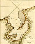 | Details | Jefferys, Thomas | 1762 |
| Antique British Plan of Puerto de Cavanas or Cabañas, Cuba |
|
Jefferys, Thomas |
|
| 1762 |
| LOC:5 |
| $325.00 | Jefferys--Thomas | Antique-British-Plan-of-Puerto-de-Cavanas-or-Cabañas--Cuba | Antique hand-colored copperplate engraved harbor chart shows Puerto de Cabañas (Cavanas), Cuba in the Artemisa province on the Northwestern coast of Cuba, about 50 km west of Havana, Cuba. In addition to depth soundings Jefferys identifies only three features in his plan of Cabañas Bay: An "aguada" or watering place, Ysla Larga, and Punta Longa.
<br></br>
The Bay of Cabañas was used as a haven for pirates to plunder Havana . In June, 1558 governor Diego de Mazariegos received news that pirate galleons had captured two Spanish caravels in a naval battle at the Bay of Cabañas. In 1586 the Spanish adopted measures for their defense against unfriendly nations and pirates. Those defensive measures stationed frigates and lookouts in the port of Cabañas in order to warn the town of Havana of impending attack.
<br></br>
This scarce nautical chart / plan was published in 1762 by the prolific British engraver and publisher Thomas Jefferys (ca.1710-1771) in "A Description of the Spanish Islands and Settlements on the Coast of the West Indies, compiled from Authentic Memoirs, Revised by Gentlemen who have Resided Many Years in the Spanish Settlements".
<br></br>
Scale in Miles. Plate 27. Page 90. |
| 2484 |  | Details | Jefferys, Thomas | 1762 |
| Jefferys' scarce plan of the city of Cartagena, Colombia |
|
Jefferys, Thomas |
|
| 1762 |
| LOC:13 |
| $800.00 | Jefferys--Thomas | Jefferys--scarce-plan-of-the-city-of-Cartagena--Colombia | Scarce large-scale birds-eye plan of the city of Cartagena, Colombia (1762) by engraver Thomas Jefferys. Emphasis on the considerable defences of Cartagena with more than one dozen defensive bastions identified by name. Secondary fortified position is labeled "Xemani or the suburb." Shows Fort Saint Philip- St. Lazaro or Baraxas and the long road to Bosquilla. Plate 5 Page 13.
<br></br>
After an apprenticeship to Emmanuel Bowen, Thomas Jefferys was one of the more prominent commercial cartographers in London during the middle of the eighteenth century. Although he was responsible for a wide variety of prints and for maps of much of the world, he is particularly remembered for his publication of many maps of North America.
<br></br>
Upon George III's accession to the throne in 1760, Jefferys became "Geographer to the King", a title signifying the status of a favored tradesman, and a reputable publisher with a sufficiently large collection of maps to fill the King's personal needs. Later, bankruptcy forced Jefferys into a partnership with Robert Sayer, a successful publisher of a diverse range of materials. Sayer provided the capital to reprint many of Jefferys' existing plates and presumably took the larger share of the profits. <a href="http://www.oshermaps.org/special-map-exhibits/percy-map/jefferys-and-north-america" target="_blank">(Online. Osher Map Library.)</a> |
| 263 |  | Details | Jefferys, Thomas | 1762 |
| Plan of la Vera Cruz from Spanish Draughts. |
|
Jefferys, Thomas |
|
| 1762 |
| LOC:5 |
| $425.00 | Jefferys--Thomas | Plan-of-la-Vera-Cruz-from-Spanish-Draughts- | Antique copperplate engraved map / port plan of the fortified city of 'la Vera Cruz' and historically significant Fort San Juan de Ulúa in the Mexican state of Veracruz. Published in 1762 by the prolific British engraver and publisher Thomas Jefferys (ca.1710-1771) in "A Description of the Spanish Islands and Settlements on the Coast of the West Indies, compiled from Authentic Memoirs, Revised by Gentlemen who have Resided Many Years in the Spanish Settlements".<br></br>
It was on the island of San Juan de Ulúa that Spanish captain Juan de Grijalva first arrived in 1518, along with conquistador and author Bernal Díaz del Castillo ("The True History of the Conquest of New Spain"). That island was also the scene of a battle in 1569 between the Spanish Navy and a fleet led by John Hawkins that included Francis Drake. The treachery that the English perceived on the part of Spain at that battle helped to fuel antagonism between the two powers for many decades. <br></br>
In Vera Cruz several key points are identified including the powder magazine, a 'magazine of masts for the galleons', and numerous churches, chapels, and sites associated with religious orders of Jesuits, Dominicans, Augustines, and Franciscans.<br></br>
Plate 14. Page 64. Contains an 11 item legend. |
| 3655 |  | Details | Jefferys, Thomas | 1762 |
| Antique plan of the Port de Baracoa, Cuba |
|
Jefferys, Thomas |
|
| 1762 |
| LOC:77 |
| $300.00 | Jefferys--Thomas | Antique-plan-of-the-Port-de-Baracoa--Cuba | A scarce antique copperplate-engraved chart of the Bay of Honey (Playa de Miel) and Port of Baracoa on Cuba's eastern tip. Baracoa is the oldest Spanish settlement in Cuba and was its first capital. The plan shows less than one dozen structures whereas in 2004, the municipality of Baracoa had a population of over eighty thousand.
<br></br>
This scarce English chart was published in 1762 by the prolific British engraver and publisher Thomas Jefferys (ca.1710-1771) in "A Description of the Spanish Islands and Settlements on the Coast of the West Indies, compiled from Authentic Memoirs, Revised by Gentlemen who have Resided Many Years in the Spanish Settlements".
<br></br>
Scale in sea leagues. At sea, a league is three nautical miles (3.45 miles). Plate 21. Page 84. |
| 4821 |  | Details | Jefferys, Thomas | 1770 |
| Rare Original Antique Chart of Amelia Island, Florida and Vicinity |
|
Jefferys, Thomas |
|
| 1770 |
| LOC:61 |
| $4,000.00 | Jefferys--Thomas | Rare-Original-Antique-Chart-of-Amelia-Island--Florida-and-Vicinity | Scarce engraved, hand-colored British navigation chart from 1770 containing three maps of Amelia Island, the Nassau River, Talbot Island and Cumberland Island, Georgia on the same sheet:
<div class="indenttextblocksingle">
<ul style="list-style-type: circle; ">
<li><b>Plan of Amelia Island in East Florida.</b> Based on an earlier survey by military engineer, surveyor, and cartographer John William Gerard de Brahm. De Brahm is known publishing “A Map of South Carolina and a Part of Georgia” in 1857.</b></li>
<li><b>A Chart of the Entrance to the St. Mary's River taken by Captn. W. Fuller.</b></li>
<li><b>A Chart of the Mouth of Nassau River and the Soundings on it taken at Low Water by Captn. W. Fuller.</b></li>
</ul>
</div>
Dedicated to John Earl of Egmont by William Fuller. Published by Thomas Jefferys, London, March 1770. |
| 151 |  | Details | Jefferys, Thomas | 1774 |
| Coast of France from Callais to Fecamp |
|
Jefferys, Thomas |
|
| 1774 |
| LOC:0 |
| $0.00 | Jefferys--Thomas | Coast-of-France-from-Callais-to-Fecamp | SOLD
<br></br>
Neat chart of the English and French coasts along the "British Channel" near the Straits of Dover. On the British side coverage extends from Beachy Head past the South Foreland. Printed for Faden and Jefferys in 1774 the two volumes in the series contained 87 charts of the sea coast and fortifications. |
| 4869 |  | Details | Jefferys, Thomas | 1774 |
| Three plans of Dunkirk France 960 1400 1658 |
|
Jefferys, Thomas |
|
| 1774 |
| LOC:13 |
| $150.00 | Jefferys--Thomas | Three-plans-of-Dunkirk-France-960-1400-1658 | Three plans of Dunkirk (Dunkerque), France on a single sheet of fine watermarked laid paper ca. 1760. Engraved by prolific British engraver and publisher Thomas Jefferys (1710-1771):
<div class="indenttextblock">
<ul style="list-style-type: circle;">
<li> A plan of Dunkirk as first walled round in 960 by Baldwin 3, Earl of Flanders.</li>
<li> A plan of Dunkirk as it was first fortifies in 1400 by Robert de Marle.</li>
<li> A plan of Dunkirk as it was fortified when taken by Marshal Turenne June 28, 1658.</li>
<br></br>
From Jefferys' "A description of the maritime parts of France, containing a particular account of all the fortified towns, forts, harbours, bays, and rivers …". Published by Faden and Jefferys, 1774. Plate III. |
| 162 |  | Details | Jefferys, Thomas | 1774 |
| Plan of the City and Harbour of Toulon |
|
Jefferys, Thomas |
|
| 1774 |
| LOC:4 |
| $175.00 | Jefferys--Thomas | Plan-of-the-City-and-Harbour-of-Toulon | Nice antique copperplate-engraved plan from 1774 of the Vauban-style fortifications around Toulon, France includes the King's harbor, merchant's harbor, arsenal, and the two city gates, where the beginnings of development outside the walls is barely visible.
<BR> </BR>
Despite its massive bastions and the support of a combined British/Spanish naval force, the fortress fell to French Republican forces in 1793 forcing the fleet to withdraw. It was during the Siege of Toulon that 24 year old Napoleon Bonaparte won a promotion from Captain to Brigadier General for his leadership including strategic placement of artillery batteries.
<BR> </BR>
Printed for Faden and Jefferys in 1774; the two volumes in the series contained 87 charts of the sea coast and coastal fortifications. |
| 1078 |  | Details | Jefferys, Thomas | 1775 |
| Antique Chart of the Yucatan Peninsula and Western Cuba |
|
Jefferys, Thomas |
|
| 1775 |
| LOC:0 |
| $0.00 | Jefferys--Thomas | Antique-Chart-of-the-Yucatan-Peninsula-and-Western-Cuba | SOLD<br></br>See another example of
<a href="https://www.rarecharts.com/ShowDetail/Creator/Jefferys--Thomas/Title/Jefferys-excellent-1775-antique-chart-of-the-Yucatan-Peninsula-to-western-Cuba/4807" target="_blank">
Jeffery's chart</a> for sale from our collection. |
| 4958 |  | Details | Jefferys, Thomas | 1775 |
| Jefferys Antique Chart of the Yucatan Peninsula |
|
Jefferys, Thomas |
|
| 1775 |
| LOC:52 |
| $650.00 | Jefferys--Thomas | Jefferys-Antique-Chart-of-the-Yucatan-Peninsula | Well-worn, decorative antique sea chart covering from the Yucatan Peninsula of Mexico to western Cuba, including Merida, Valladolid, Loggerhead Key, Cozumel, Isla Mujeres, etc. By English cartographer Thomas Jefferys. A fleet of galleons is shown on a plotted track labeled: "Gallions Track from Cartagena", while two ships head west along a plotted track labeled: "Track from Cape Catoche to Campeche." To round out the cast of characters a third ship, apparently a privateer, exits a shorter track between two rocky areas. That track is noted as the "Passage del Corsario" (A corsair was a privateer, or pirate acting with the explicit backing of a foreign government).
<br></br>
From Sayer's and Bennett's atlas titled: The West-India Atlas: or, a compendious description of the West-Indies: illustrated with forty one correct charts and maps, taken from actual surveys."
<br></br>
Publishers attribution reads: "London. Printed for Rob.t Sayer, Map and Print seller. No 53 Fleet Street as the Act directs 20th Feb.y 1775. |
| 4807 |  | Details | Jefferys, Thomas | 1775 |
| Jefferys excellent 1775 antique chart of the Yucatan Peninsula to western Cuba |
|
Jefferys, Thomas |
|
| 1775 |
| LOC:0 |
| $1,050.00 | Jefferys--Thomas | Jefferys-excellent-1775-antique-chart-of-the-Yucatan-Peninsula-to-western-Cuba | Antique engraved sea chart from <b>Yucatan</b> Peninsula to western Cuba. Numerous large square-rigged ships are depicted enroute to either Campeche; Cartagena, Colombia; or Havana, Cuba.
<br></br>
Published under Thomas Jeffery's name by Sayer and Bennet. Includes <b>Merida, Valladolid, Loggerhead Key, Cozumel, Isla Mujeres</b>, etc.
<br></br>
This 1775 original British privately-published chart is a continuation of Jefferys' magnificent map of Cuba, which omits the western tip of the Pearl of the Antilles, Cuba.
<br></br>
A fleet of square-rigged galleons is shown sailing on a plotted track labeled: "Gallions Track from Cartagena", while two ships sail west along a plotted track labeled: "Track from Cape Catoche to Campeche." To round out the cast of characters a third ship, apparently a privateer, exits a shorter track between two rocky areas. That track is noted as the "Passage del Corsario." Note: a favorite tactic of pirates, corsairs, and cocaine smugglers has long been to use local knowledge of the water depth and hazards to frustrate pursuers.
<br></br>
From Sayer's and Bennett's atlas titled: The West-India Atlas: or, a compendious description of the West-Indies: illustrated with forty one correct charts and maps, taken from actual surveys."
<br></br>
Publishers attribution reads: "London. Printed for Rob.t Sayer, Map and Print seller. No 53 Fleet Street as the Act directs 20th Feb.y 1775. According to Rumsey <div class="indenttextblock">
"Sayer and Bennet acquired his [Jefferys'] materials in preparation for this atlas, and published the atlas posthumously under his name (as they did with the American Atlas) in 1775. The heart of this atlas and the most detailed part is the sixteen sheet large chart and index sheet of the whole of the West Indies. (
<a href="http://www.davidrumsey.com/luna/servlet/detail/RUMSEY~8~1~2795~310044:The-coast-of-Yucatan-from-Campeche-" target="_blank">Internet </a>)
</div> |
| 1451 |  | Details | Jefferys, Thomas | 1775 |
| Mayo Jefferys Sayers Chart of Barbados West-India Atlas |
|
Jefferys, Thomas |
|
| 1775 |
| LOC:0 |
| $0.00 | Jefferys--Thomas | Mayo-Jefferys-Sayers-Chart-of-Barbados-West-India-Atlas | SOLD<BR></BR>
Fine antique British chart of the Island of Barbados in the Caribbean Sea. With two inset coastal elevation views of Barbados as seen from W.N.W. at a distance of 9 leagues (27 mi.) offshore and 7 leagues (21 mi.) offshore. Barbados is an island country in the Lesser Antilles, in the Caribbean region of North America. After a survey by William Mayo. Sheet X.
<br></br>
The chart is from the scarce <b>first issue of The West-India Atlas, 1775 by Sayer</b>, the other issues being 1781, 1787, 1794, 1796, 1807, and 1818 published by Sayer and then later by Laurie and Whittle. <a href="https://www.davidrumsey.com/home" target="_blank">(Online).</a>
<br></br>
"The West-India Atlas: or, A Compendious Description of the West-Indies: illustrated with Forty Correct Charts and Maps, taken from Actual Surveys. Together with An Historical Account of the Several Countries and Islands which compose that part of the world. Their Discovery, Situation, Extent, Boundaries, Product, Trade, Inhabitants, Strength, Government, Religion, &c."
<br></br>
Authors: William Mayo, Thomas Jefferys.
Publishers: Robert Sayer.
Jefferys died in 1771; Sayer acquired Jefferys' materials in preparation for this atlas, and published the atlas posthumously under his name.
Publisher's attribution reads: London, Printed for Robert Sayer, Map and Printseller Number 53 in Fleet Street as the act directs 20 February 1775. |
| 3594 |  | Details | Jefferys, Thomas | 1775 |
| Antique nautical chart of Martinique West-India Atlas Jefferys Sayer |
|
Jefferys, Thomas |
|
| 1775 |
| LOC:0 |
| $900.00 | Jefferys--Thomas | Antique-nautical-chart-of-Martinique-West-India-Atlas-Jefferys-Sayer | Fine, very desirable chart of Martinique (Martinico) in the Caribbean Sea. A beautiful British-published chart based on hydrographic surveys by English engineers before 1775. Inset port plan of Cul de Sac Royal or Fort de France Bay.
<br></br>
The chart is from the scarce <b>first issue of 1775 by Sayer</b>, the other issues being 1781, 1787, 1794, 1796, 1807, and 1818 published by Sayer and then Laurie and Whittle. <a href="https://www.davidrumsey.com/home" target="_blank">(Online).</a>
Publishers attribution reads: "London. Printed for Rob.t Sayer, Map and Printseller. No 53 in Fleet Street as the Act directs 20th Feb.y 1775.
<br></br>
From: "The West-India Atlas: or, A Compendious Description of the West-Indies: illustrated with Forty Correct Charts and Maps, taken from Actual Surveys. Together with An Historical Account of the Several Countries and Islands which compose that part of the world. Their Discovery, Situation, Extent, Boundaries, Product, Trade, Inhabitants, Strength, Government, Religion, &c."
Authors: Gerard van Keulen, Thomas Jefferys.
Publishers: Robert Sayer.
Jefferys died in 1771; Sayer acquired Jefferys' materials in preparation for this atlas, and published the atlas posthumously under his name. |
| 3591 |  | Details | Jefferys, Thomas | 1775 |
| Antique Chart of Coast of West Florida and Louisiana |
|
Jefferys, Thomas |
|
| 1775 |
| LOC:51 |
| $0.00 | Jefferys--Thomas | Antique-Chart-of-Coast-of-West-Florida-and-Louisiana | SOLD<br><br>
Fine antique nautical chart and an important chart for the collector of Gulf Coast history. Geographic coverage on this antique chart extends from Sabine Pass, Texas (Cabo del Norte ) to Apalachicola Bay in the Florida Territory.
<br></br>
This first-edition British copper-engraved navigational chart documents the lack of knowledge about Chandeleur Sound (1775) where a note about the waters inside those barrier islands states "Shallow water with many small islands but very little known". In the later second state (not shown) the depiction of the sound is updated with greater detail (Breton Island, Grand osier Island) and the placename "Bay of Spiritu Santu" fills in what we now call Chandeleur Sound. Bayou Lafourche is labeled "Chetimachas River" after the Chitimacha Indians who were known to inhabit the area near Donaldsonville, La. Barataria Bay is labeled "Lake Ouachas".
<br></br>
A decorative flotilla graces the middle of our chart, highlighting a dashed line from west to southeast. That dotted line, Jeffery noted was, "The Flota's Track from la Vera Cruz [Mexico] to Havanna to avoid the Trade Winds".
<br></br>
Very attractive decorative compass rose.
<br></br>
From Sayer's and Bennett's atlas titled: "The West-India Atlas: or, a compendious description of the West-Indies: illustrated with forty one correct charts and maps, taken from actual surveys."
<br></br>
Publishers attribution reads: "London. Printed for Rob.t Sayer, Map and Printseller. No 53 Fleet Street as the Act directs 20th Feb.y 1775. According to Rumsey <div class="indenttextblock">
"Sayer and Bennet acquired his [Jefferys'] materials in preparation for this atlas, and published the atlas posthumously under his name (as they did with the American Atlas) in 1775. (
<a href="http://www.davidrumsey.com/luna/servlet/detail/RUMSEY~8~1~2795~310044:The-coast-of-Yucatan-from-Campeche-" target="_blank">Internet </a>)
</div> |
| 1460 |  | Details | Jefferys, Thomas | 1775 |
| Antique Chart of Guadeloupe in the Caribbean Sea Jefferys Sayer |
|
Jefferys, Thomas |
|
| 1775 |
| LOC:51 |
| $800.00 | Jefferys--Thomas | Antique-Chart-of-Guadeloupe-in-the-Caribbean-Sea-Jefferys-Sayer | Fine antique British chart of the island of Guadeloupe ("Guadaloupe") in the Caribbean Sea. Includes the nearby islets of Marie-Galante, Isle des Saintes, Petit Terre, and la Desirade. Jefferys names three main sections of Guadeloupe: Basse Terre, Cares Terre, and Grand Terre. With depth soundings, sand banks, and anchorages identified. Fine central compass rose.
<br></br>
Attribution reads: London. Printed for Robert Sayer Map and Printseller. No. 53 Fleet Street as the act directs 20 February, 1775.
<br></br>
The chart is from the scarce <b>first issue of The West-India Atlas, 1775 by Sayer</b>, the other issues being 1781, 1787, 1794, 1796, 1807, and 1818 published by Sayer and then Laurie and Whittle. The volume combined both the elements of an atlas and a pilot, with geographic and hydrographic information. The maps include those for the larger individual islands of the West Indies. <a href="https://www.davidrumsey.com/home" target="_blank">(Online).</a> |
| 3592 |  | Details | Jefferys, Thomas | 1775 |
| Antique Chart of the Peninsula and Gulf of Florida. |
|
Jefferys, Thomas |
|
| 1775 |
| LOC:51 |
| $0.00 | Jefferys--Thomas | Antique-Chart-of-the-Peninsula-and-Gulf-of-Florida- | SOLD <br></br>
Fine first edition British navigational chart documents the Peninsula of Florida. Includes portions of the Bahamas with Grand Bahama Island, Great Abaco Island, Eleuthera, Nassau (Providence) and more. Tampa Bay clearly marked.
<br></br>
Much to inspect with a magnifying glass. Correctly shows the current from the Gulf Stream flowing from South to North.
<br></br>
From Sayer's and Bennett's atlas titled: "The West-India Atlas: or a compendious description of the West-Indies: illustrated with forty one correct charts and maps, taken from actual surveys."
<br></br>
Publishers attribution reads: "London. Printed for Rob.t Sayer, Map and Printseller. No 53 Fleet Street as the Act directs 20th Feb.y 1775. According to Rumsey <div class="indenttextblock">
"Sayer and Bennet acquired his [Jefferys'] materials in preparation for this atlas, and published the atlas posthumously under his name (as they did with the American Atlas) in 1775. The heart of this atlas and the most detailed part is the sixteen sheet large chart and index sheet of the whole of the West Indies. (
<a href="http://www.davidrumsey.com/luna/servlet/detail/RUMSEY~8~1~2795~310044:The-coast-of-Yucatan-from-Campeche-" target="_blank">Internet </a>)
</div> |
| 3624 |  | Details | Jefferys, Thomas | 1775 |
| Antique Chart of the Turks Islands and Turks Islands Passage |
|
Jefferys, Thomas |
|
| 1775 |
| LOC:51 |
| $900.00 | Jefferys--Thomas | Antique-Chart-of-the-Turks-Islands-and-Turks-Islands-Passage | A fine original antique British chart of the <b>Turks Islands</b> in the Caribbean Sea engraved by Thomas Jefferys. Covers Grand Turk Island, Salt Key, Sand Key, Cotton Island, Pelicans Island, and others in the vicinity. A foundational map for collectors, it is the earliest obtainable sea chart to focus solely on the Turks Islands, today a British Overseas Territory. (Note: The Caicos Islands are not included on this chart.)
<br></br>
Shows rocks, banks, reefs, shoals, anchorages, "Salt Rakers Huts" on the 2 main islands, rhumb lines. Printing done from a hand-engraved copper plate by Jefferys.
<br></br>
At Sand Key at point "A", on the Southern Bluff, a note reveals <div class="indenttextblock"> " Upon this bluff (Sand Key) the French, after the late Peace, erected a Sea Mark which they were soon obliged to demolish."</div>
<BR/>
The chart is from the scarce <b>first edition of the West India Atlas" 1775 by Sayer</b>, the other issues being 1781, 1787, 1794, 1796, 1807, and 1818 published by Sayer and then Laurie and Whittle. <a href="https://www.davidrumsey.com/home" target="_blank">(Online).</a>
<br></br>
From: "The West-India Atlas: or, A Compendious Description of the West-Indies: illustrated with Forty Correct Charts and Maps, taken from Actual Surveys. Together with An Historical Account of the Several Countries and Islands which compose that part of the world. Their Discovery, Situation, Extent, Boundaries, Product, Trade, Inhabitants, Strength, Government, Religion, &c."
Author: Thomas Jefferys.
Publishers: Robert Sayer.
Jefferys died in 1771; Sayer acquired Jefferys' materials in preparation for this atlas, and published the atlas posthumously under his name. |
| 895 |  | Details | Jefferys, Thomas | 1775 |
| Antique Chart of Southern Mexico from Veracruz to Ciudad del Carmen |
|
Jefferys, Thomas |
|
| 1775 |
| LOC:51 |
| $920.00 | Jefferys--Thomas | Antique-Chart-of-Southern-Mexico-from-Veracruz-to-Ciudad-del-Carmen | Beautiful antique British chart of southern Mexico and Guatemala centered on the Mexican state of Oaxaca. This first edition chart by Thomas Jefferies in 1775, includes coastal features of the <b>Bay of Campeche</b> to the north and the <b>Gulf of Tehuantepec</b> on the Pacific or southern coast. This chart contains significant interior details including volcanos (e.g. Vulcan de San Martin or "el Pan de Mizapa"), rivers, mountains, and numerous towns and villages.
<br></br>
First, more scarce edition with spelling error in the title: "NEUva Veracruz". In the second edition the title was corrected to "NUEva Vera Cruz".
<br></br>
On the northern Gulf Coast in Mexico's Veracruz and Tabasco states significant habitations include <b>Nueva Vera Cruz</b>, San Juan de Ulua, a fort, guardhouse, and dock near the Laguna de Alvarado ("Rio Alvarado"), smaller villages both near the mouth of the Rio Grijalva and Frontera, and in the vicinity of Ciudad del Carmen ("Y. Triste"). Fascinating note south of the Laguna de Terminos at far right corner reads "<b>Logwood Creeks</b> occupied formerly by the English". Logwood, a small tree used to produce dye for clothing, was one of the main exports from the region. Notably, in 1675, the explorer and sometime buccaneer William Dampier traveled to "Campeachy" and worked among the logwood-cutters.
<br></br>
On the Pacific Coast, in the states of Oaxaca and Chiapas noted villages include: Puerto Angel ("Puerto de Angeles"), Puerto Escondido, Galera ("Punta de la Galera"), Tangolunda ("Tangolo or Tangolotanga"), "Puerta de la Ventosa", Salina Cruz, and Puerto San Jose, Guatemala ("Port of Guatimala").
<br></br>
Publishers attribution reads: "London. Printed for Rob.t Sayer, Map and Printseller. No 53 Fleet Street as the Act directs 20th Feb.y 1775. Online sources indicate that the misspelling of Nueva as "Neuva" is a characteristic of Jeffery's first state of this chart. |
| 1452 |  | Details | Jefferys, Thomas | 1775 |
| Jefferys Sayers Chart of Caribbee Islands Virgin Islands to Barbados |
|
Jefferys, Thomas |
|
| 1775 |
| LOC:0 |
| $0.00 | Jefferys--Thomas | Jefferys-Sayers-Chart-of-Caribbee-Islands-Virgin-Islands-to-Barbados | SOLD <br></br>
Exciting antique British chart of the "Caribbee Islands" -- Caribbean Islands. Chart coverage includes the Virgin Islands (St. Thomas, St. Croix, St. John's, Tortola…), Antigua, Guadeloupe, Dominica, Martinique, St. Lucia, St. Vincent, and Barbados.
<br></br>
The chart is from the scarce <b>first issue of The West-India Atlas, 1775 by Sayer</b>, the other issues being 1781, 1787, 1794, 1796, 1807, and 1818 published by Sayer and then Laurie and Whittle. <a href="https://www.davidrumsey.com/home" target="_blank">(Online).</a>
<br></br>
One French online site of Martinique describes key features of Jefferys' nautical chart:
<hr>
<div class="indenttextblock">
C'est une carte marine à latitudes croissantes de 20 lieues marines au degré. Elle est très esthétiquement quadrillée de rhumbs, éléments indispensables à l'époque pour obtenir l'adhésion des utilisateurs. Elle est de plus joliment agrémentée de représentations, somme toute très sobres, de vaisseaux de diverses nations, qui n'entravent pas le caractère opérationnel de la carte.
</BR>
Quelques rares sondes indiquent dans les principaux canaux et passes les profondeurs marines. Elles sont parfois présentes sur les dangers reconnus. Entre Saint-Eustache et Avès, Jefferys met en évidence la longue barrière de hauts fonds dont la largeur atteindrait en moyenne deux lieues marines et la profondeur entre 10 et 20 fathoms.
</BR>
Jefferys y précise que certaines sondes ont été prises par les français, marins à bord du navire le «Toulouse», en 1720. La carte présente les itinéraires des principaux "débouquements", notamment celui des Vierges, qui était employé par la plupart des marines pour le retour en Europe. <a href="http://cartes-martinique.pagesperso-orange.fr/Car_gb.htm" target="_blank">(Online.)</a>
<hr>
</div> |
| 2489 |  | Details | Jefferys, Thomas | 1775 |
| Antique Chart of The Island of Jamaica and Cape Gracias a Dios |
|
Jefferys, Thomas |
|
| 1775 |
| LOC:51 |
| $1,675.00 | Jefferys--Thomas | Antique-Chart-of-The-Island-of-Jamaica-and-Cape-Gracias-a-Dios | Fine antique sea chart covering from the Mosquito Coast (labeled Moskito King's Party) of Honduras and Nicaragua to Jamaica, a distance over water of more than 400 miles. First state chart with numerous navigational details such as depth soundings, reefs, and the prevailing current.
<br></br>
Includes ships' tracks labeled 'Galleons Track from Cartagena to Havana' that skirt numerous reefs on the dangerous voyage from Colombia to Cuba. These details are worthy of study under magnification for the insight they provide on the key success factors for seafarers in the mid-eighteenth century.
<div class="indenttextblock">
<ul style="list-style-type: circle;">
<li>South Key- "Fresh water under a large wild grape tree."</li>
<li>"Main Cape Reef and Keys by the Spaniards los Tiburones"</li>
<li>"Serrana alias The English Bank called also Pearl Island"</li>
<li>"Quinta el Sueno called by the baymen Guana Reef"</li>
<li>Southwest of Jamaica- "La Bivora or Pedro Shoals according to the surveys of Spanish pilots in 1727 and 1750"</li>
</ul>
</div>
From Sayer's and Bennett's atlas titled: The West-India Atlas: or, a compendious description of the West-Indies: illustrated with forty one correct charts and maps, taken from actual surveys."
<br></br>
Publishers attribution reads: "London. Printed for Rob.t Sayer, Map and Printseller. No 53 Fleet Street as the Act directs 20th Feb.y 1775. According to Rumsey <div class="indenttextblock">
"Sayer and Bennet acquired his [Jefferys'] materials in preparation for this atlas, and published the atlas posthumously under his name (as they did with the American Atlas) in 1775. The heart of this atlas and the most detailed part is the sixteen sheet large chart and index sheet of the whole of the West Indies. (
<a href="http://www.davidrumsey.com/luna/servlet/detail/RUMSEY~8~1~2795~310044:The-coast-of-Yucatan-from-Campeche-" target="_blank">Internet </a>)
</div> |