| | Thumbnail | | Creator | Date | Title / Author / Date / Location | Price | | | Description |
| 1017 | 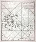 | Details | Anonymous | |
| Anonymous French chart of the east Mediterranean sea Sheet III |
|
Anonymous |
|
|
| LOC:58 |
| $800.00 | Anonymous | Anonymous-French-chart-of-the-east-Mediterranean-sea-Sheet-III | Interesting possibly unrecorded chart of the eastern Mediterranean Sea labeled "Feuille III" (Sheet 3.) Labels the key regions "Romanie, Caramanie, Natolie, Syrie". The regional naming and the area covered are generally consistent with those on the third (eastern) sheet of Bellin's "Carte de la Mer Mediterranee en Trois Feuilles" published in 1745 (based on Grognard's survey). This chart is nicely engraved and is printed on heavy wove paper, all signs of a quality in a published chart of that era.
<br></br>
However, although this chart bears the designation "Feuille III" and uses the French language, it is different in many ways. This chart is untitled, uses portrait format rather than landscape format, and displays very different geography- omits many key geographic features and places other features in different locations (e.g.. Isle Provencale near Alexandrette). Also significant is the absence of a distance scale and in the location where the title block is typically found, a list of eight islands with the comment that the list is of islands between the meridian of Cape St. Ange and Alexandrette (Iskenderun, Turkey). |
| 5133 | 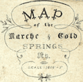 | Details | Anonymous | |
| Manuscript map of the Marche and Cold Springs, Arkansas |
|
Anonymous |
|
|
| LOC:0 |
| $0.00 | Anonymous | Manuscript-map-of-the-Marche-and-Cold-Springs--Arkansas | SOLD
<br></br>
Manuscript map of the Marche and Cold Springs, Arkansas ca. 1890. The map is related to early Polish emigration to the area and was drawn or owned by "Helen Ch." (assumed Helen Choinski). Helen Choinski was the daughter of Timothy Choinski, a Polish nobleman, who founded the community at Warren, Arkansas in 1877. Helen Choinski worked as local Postmistress and telegrapher and in 1894 Helen married M. Schnable who worked for the Cotton Belt Railway. The map shows considerable skill and training in surveying and map making, but there is no indication Helen Choinski possessed such skills.
<br></br>
While in Wisconsin, Count Timothy von Choinski, a nobleman and political refuge from Poland, became concerned with the suffering of many of his fellow Polish immigrants who were residing in the slums of large cities such as New York and Chicago. Choinski wished to improve the working and living condition of these immigrants and began the search for a farming environment that was more familiar to these Poles. After meeting with the land agent for the Little Rock and Fort Smith Railway in March 1877, Choinski purchased 22,000 acres ten miles northwest of Little Rock.
<br></br>
Polish resettlement began in 1877 at Old Warren, Arkansas ten miles north of Little Rock. Later renamed the "Marche" after the French word for market, the community became a magnet for Polish emigres. The settlement of Marche is one of the most successful efforts to resettle immigrants in Arkansas history.
<br></br>
Sources:
https://encyclopediaofarkansas.net/entries/marche-pulaski-county-3295/
</br>
https://honors.uca.edu/wiki/index.php/Marche |
| 171 |  | Details | Anonymous | 1600 |
| Des Dieux |
|
Anonymous |
|
| 1600 |
| LOC:0 |
| $50.00 | Anonymous | Des-Dieux | Fanciful antique woodblock engraving of a small galley. French text at bottom and verso. Vines cover the mast, oars and rudder and several lions are seen on deck while in the foreground two sea creatures swim menacingly. Ca 1600. Unknown origin. Page 543. |
| 1337 | 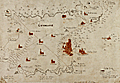 | Details | Anonymous | 1660 |
| Very old manuscript map of Guernsey Island |
|
Anonymous |
|
| 1660 |
| LOC:0 |
| $0.00 | Anonymous | Very-old-manuscript-map-of-Guernsey-Island | SOLD <br></br>
<br></br>
Very old manuscript map of the island of Guernsey ( "Gernsaye" ), one of the Channel Islands in the English Channel near the French coast. Estimated ca. 1660. Locates all the churches on the island. Saint Peter Port is referenced only as "the towne". The map shows the "Chastion Cornet" or Castle Cornet offshore where today it is but a short walk from town center.
<br></br>
Manuscript signature at bottom "Reginaldo Wolfio Autore". The map does not appear to be drawn with much skill, raising the possibility that this is a quick copy of another work, perhaps a map of Guernsey by Blaeu. Contains many of the guide lines used to construct the map, perhaps based on bearings from key points.
<br></br>
A few wormholes passing through the original and the backing paper suggest substantial age to the work. |
| 126 |  | Details | Anonymous | 1660 |
| Untitled - Stockholm mid 17th century |
|
Anonymous |
|
| 1660 |
| LOC:0 |
| $0.00 | Anonymous | Untitled---Stockholm-mid-17th-century | SOLD<BR> </BR>
Antique view of Stockholm with 'Admiralty Island' in the background records a procession of robed Senators and other nobles including King Carolus. In the distance to the left is the "Palatium Admiralitatis", the Skeppsholmen Admiralty palace built in 1650 and to the right- Kastellholmen. Depicts numerous naval vessels firing a salute. Contains emblems for Livonia, Scania, Finnonia Meridionalis, Finnonia Septentrionalis, and Uplandia. <BR> </BR>
It is unclear what occasion this engraving commemorates but it is likely after 1658 when Denmark was forced to cede control of Scania to Sweden. Possibly records the coronation procession of King Charles XI in 1672. |
| 381 | 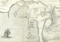 | Details | Anonymous | 1675 |
| Plan de la Ville de Rode |
|
Anonymous |
|
| 1675 |
| LOC:2 |
| $950.00 | Anonymous | Plan-de-la-Ville-de-Rode | Scarce engraving of the port of Rode (Rhodes), Greece decorated with a bat-form title cartouche, a square-rigged warship, and three galleys. References on the plan to the 'Grand Master' and 'Sultan Suleiman' suggest that the map was intended to illustrate the Siege of Rhodes in 1522 when the Knights of Rhodes were defeated and driven out by the Ottomans. That order later became known as the 'Knights of Malta' after they established residence on the island of Malta in 1530.
<BR> </BR>
We cannot locate an identical copy of this anonymous work anywhere on-line but the topographic details are nearly identical to those in a map by Dapper from 1687. This example probably dates from a period between 1650 - 1675 because this map contains more explanatory detail (in French) than Dapper's map and the strapwork cartouche points to an earlier style.<BR> </BR>
Numerous geographic descriptions include: the palace of the Grand Master; port des galeres; Tour de St. Jean; port des vaisseaux; the old walled village of Rhodes, and two long breakwaters, each protected by a tower at the end. Strapwork mileage scale. |
| 4742 | 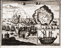 | Details | Anonymous | 1680 |
| Antique engraving of the bombardment of St. Malo France |
|
Anonymous |
|
| 1680 |
| LOC:77 |
| $150.00 | Anonymous | Antique-engraving-of-the-bombardment-of-St--Malo-France | Anonymous antique engraved print of the bombardment of St. Malo, France, probably during the 17th century. Decorative unusual copper engraved map ca. 1680 showing a naval siege of Saint-Malo, France. The plate show the city with its buildings, churches, harbor and town walls. Inset showing a warship "Das Machine Schiff" (probably a bomb vessel). Verso blank. |
| 984 | 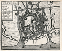 | Details | Anonymous | 1680 |
| Old map of Ostend, Belgium. |
|
Anonymous |
|
| 1680 |
| LOC:7 |
| $60.00 | Anonymous | Old-map-of-Ostend--Belgium- | Small anonymous antique map of Ostend / Ostende / Oostende, Belgium (ca. 1680) which today is located in the province of West-Flanders. The old map shows numerous water features, redoubts, and defensive walls with bastions surrounding the city.
<br></br>
A legend at top left is keyed alphabetically to several major features including: the Kerck (Church), Kyasenest, Strand, Nieuwe Haven, and city gates (Poorte). This map bears a strong resemblance to a map of Ostende published by Blaeu in 1647. |
| 52 |  | Details | Anonymous | 1716 |
| Plan des environs de Dunkerque et Mardick |
|
Anonymous |
|
| 1716 |
| LOC:9 |
| $175.00 | Anonymous | Plan-des-environs-de-Dunkerque-et-Mardick | This antique French map on watermarked, chain-laid paper depicts the environs of Mardick and Dunkirk within 3 years after the demolition of the Dunkirk harbor in 1714. <BR> </BR>
At the end of the War of Spanish Succession England agreed to turn over Dunkirk, which it captured in 1708, to the French. In order to prevent the port's usage as a base for privateers and sea raiders the English demolished the harbor and city walls. This map depicts the French's quick response to the demolition- a new canal near Mardick that re-connected Dunkirk's harbor to the sea. |
| 1156 | 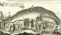 | Details | Anonymous | 1744 |
| A Whale Female and the Windlass whereby the Whales are brought on shore |
|
Anonymous |
|
| 1744 |
| LOC:1 |
| $275.00 | Anonymous | A-Whale-Female-and-the-Windlass-whereby-the-Whales-are-brought-on-shore | Fine antique copper-plate engraving of a dead whale lying on the Greenland shore prior to flensing. A worker has marked a grid on the whale and is about to begin work removing the blubber with a large flensing tool. Shore-based flensing or cutting of the whales flesh was the method used by Nantucketer's during their early shore fishery . As the fishery moved offshore flensing was conducted by bringing the whale alongside the whaling ship. Illustrates Monck's "Account of a Most Dangerous Voyage to Greenland".
<br></br>
Shows windlasses, a sled, anchor, and flensing tools used to haul the carcass ashore and remove the whale's blubber.
<br></br>
Originally published in 1619, this state is from Churchill's Collection of Voyages & Travel (1744) vol. I. Page 444. |
| 1157 | 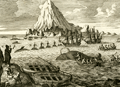 | Details | Anonymous | 1744 |
| Antique Greenland offshore whaling engraving |
|
Anonymous |
|
| 1744 |
| LOC:0 |
| $0.00 | Anonymous | Antique-Greenland-offshore-whaling-engraving | SOLD
<br></br>
Fine antique copper-plate engraving of the ships and boats engaged in the whaling process ca 1620. Illustrates John Monck's "Account of a Most Dangerous Voyage to Greenland" based on his voyage in 1619 and 1620.
<br></br>
Monck described the scene:
<div class="indenttextblock">
"The manner of catching and killing of the whales is performed thus: As soon as they spy a whale either from the shore or ship they put out three chalops manned with six men each, among whom is one being called the Harpuner, is the person who is first to wound the whale with his harpun." [Note: A chalop or shallop is a light sailing boat mainly used as a fishing tender].
</div>
</br>
Originally published in 1619, this state is from Churchill's Collection of Voyages & Travel (1744) vol. I. Page 442. |
| 439 |  | Details | Anonymous | 1744 |
| A Whale Female and the Windlass |
|
Anonymous |
|
| 1744 |
| LOC:0 |
| $0.00 | Anonymous | A-Whale-Female-and-the-Windlass | SOLD<br></br>
Copper-plate engraving of a dead whale lying on the Greenland shore prior to butchering. A worker has marked a grid on the whale and is about to begin work removing the blubber with a large flensing tool. Shows windlasses and a sled used to haul the carcass ashore. Originally published in 1619, this state is from Churchill's Collection of Voyages & Travel (1744) vol. I. Page 444. |
| 471 |  | Details | Anonymous | 1750 |
| La Boussole |
|
Anonymous |
|
| 1750 |
| LOC:1 |
| $55.00 | Anonymous | La-Boussole | Mid 18th century hand-colored copperplate engraving of a ship's compass mounted in a binnacle. Detailed views of the compass card and compass needle. |
| 411 |  | Details | Anonymous | 1750 |
| A Prospect of Mount Vesuvius with its Irruption in 1630 |
|
Anonymous |
|
| 1750 |
| LOC:50 |
| $225.00 | Anonymous | A-Prospect-of-Mount-Vesuvius-with-its-Irruption-in-1630 | Hand colored engraving depicting the eruption of Mount Vesuvius near Naples, Italy more than a century earlier. From the April 1750 edition of Gentleman's Magazine. Features depicted include the catastrophic explosion of Vesuvius, the Torre del Greco (Greek Tower) covered with ashes, two barges on which several people saved themselves, and the bridge "la Nunciato". |
| 653 | 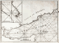 | Details | Anonymous | 1750 |
| Gulf of Aden and Yemen |
|
Anonymous |
|
| 1750 |
| LOC:0 |
| $375.00 | Anonymous | Gulf-of-Aden-and-Yemen | Uncommon anonymous mid-18th century British nautical chart labeled "Arabian Gulph". Includes the lower Red Sea, Gulf of Aden, Coast of Yemen, and the island of Socotra. Includes parts of the Somalian coast. Copperplate engraved working chart on chain laid paper with no watermark.
<br></br>
Lack of a title, authors name, or date makes the source of the chart hard to place but the style, English wording, and lack of a longitude scale is consistent with British charts published ca. 1740 - 1770. The missing title information or any form of attribution is in itself unusual, as during the period when this map was produced, publishers were only too happy to "borrow" other's works to be sold under their own name.
<br></br>
Noted geographical features include Mocha and Aden in Yemen, Zea Hill, Birim Island (I. Babel-Mandel ), The Eight Islands, Cabo St. Anthony, Black Point, The Asses Ear, Doffar, Bird Island, Berbera ( Barbara ), Cape Guardafui ( Guardafoy ) , Somalia and part of the Gulf of Tadjoura and Djibouti. We have been unable to locate another example of this chart.
<br></br>
Plate 2. |
| 838 | 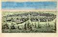 | Details | Anonymous | 1750 |
| Hand-colored Antique Vue d'Optique View of Venice, Italy |
|
Anonymous |
|
| 1750 |
| LOC:7 |
| $275.00 | Anonymous | Hand-colored-Antique-Vue-d-Optique-View-of-Venice--Italy | Hand colored copperplate engraved view of Venice, Italy from the mid 18th century. This Vue d'Optique, when viewed through the lens of a zograscope ( left-right reversed ) would have shown that city of islands as it would have appeared from the South looking slightly northwest across the Giudecca and San Giorgio Maggiore to Piazza san Marco.
<br></br>
Shown underway in the lagoon, in the Giudecca Canal, and in Saint Mark's Basin are numerous ships- galleys, xebecs, and square-rigged vessels , as well as dozens of Venice's signature gondolas. |
| 528 |  | Details | Anonymous | 1750 |
| Smyrna |
|
Anonymous |
|
| 1750 |
| LOC:2 |
| $350.00 | Anonymous | Smyrna | Original etched view of Smyrna (Izmir) Turkey dating to about the mid 18th century. Foreground depicts European-style warships at anchor. Background shows several forts and a minaret. |
| 1249 | 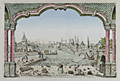 | Details | Anonymous | 1750 |
| Jeddah, Saudi Arabia antique vue d'optique |
|
Anonymous |
|
| 1750 |
| LOC:0 |
| $0.00 | Anonymous | Jeddah--Saudi-Arabia-antique-vue-d-optique | SOLD
<br></br>
Antique optical print or vue d'optique of Jeddah, Saudi Arabia the port for Mecca or Lamekk (la Mecque) ca 1750. This attractive engraved print is one of the earliest available views of Jeddah, an important trading port city on the Red Sea coast of Saudi Arabia.
<br></br>
With a population currently at 4.2 million people, Jeddah is the largest city in Makkah Province, the largest sea port on the Red Sea, and the second-largest city in Saudi Arabia. |
| 3577 | 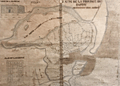 | Details | Anonymous | 1750 |
| MS 18th century hydrographic map of the Fayoum Region - Egypt - Arsinoe - Lake Moeris |
|
Anonymous |
|
| 1750 |
| LOC:0 |
| $17,000.00 | Anonymous | MS-18th-century-hydrographic-map-of-the-Fayoum-Region---Egypt---Arsinoe---Lake-Moeris | Rare detailed, unsigned French manuscript hydrographic map of the Fayoum region of Egypt “the Land of the Lake” with Lake Moeris (Qarun). With an elevation view and floor plan of a building considered to be the "Labyrinthe" mentioned by Herodotus. Ca. 1720 - 1750. Possibly the earliest map to focus on the Fayoum region.
<br></br>
This 18th century MS map locates archaeological sites and features the extensive network of rivers, streams, and canals that emptied into Lake Moeris from the Nile River via the Bahr Yusuf canal. Shows seven smaller canals from the Bahr Yusuf emptying into "Lake Moeris ou de Caron Nomne a presant Lac de la Corne". The hydrography and naming (ex. "Lac de la Corne", "Chateau de Caron") are similar to <a href="https://gallica.bnf.fr/ark:/12148/btv1b531002007/f1.item.zoom" target="_blank">Claude Sicard's map of Egypt</a> copied in MS by Guillaume Delisle in 1726.
<br></br>
The Fayoum (also Fayum, Faioum) region was once the center of the cult of Sobek, an Egyptian deity associated with the crocodile. Medinet el-Faiyum or Shedet was the ancient regional capital. The town was called "Crocodilopolis" by the Greeks (renamed Arsinoë by the Romans). Camels and crocodile are shown near the southwest shore of the lake with several pyramids, grottos, ruins, and Coptic Christian sites.
<br></br>
The map wrongly identifies the Ptolemaic temple at Qasr Qaroun as the Labyrinth described by Herodotus.
<br></br>
French explorers who first vested the Fayoum region include Paul Lucas (1714-17), Jomard (1800), P.D. Martin (1801), and Linant de Bellefonds (1821). By 1800 Edme-Francois Jomard in "Emplacement de l'ancien lac Moaris et du Labyrinthe dans le Fayoum d'après tous les Auteurs" had correctly determined that the site of the Labyrinth lay not at Qasr Qaroun, but rather at a mud-brick temple near Hawara. Our estimated date of this map to the 18th century rests on this timeline and on dates of other maps from the same purchase. |
| 1117 |  | Details | Anonymous | 1766 |
| A Plan of the Siege of the Havana 1762 |
|
Anonymous |
|
| 1766 |
| LOC:0 |
| $0.00 | Anonymous | A-Plan-of-the-Siege-of-the-Havana-1762 | SOLD<br></br>Antique map or plan of Havana, Cuba. This concise engraved harbor plan shows the disposition of British forces as they besieged and captured the city of Havana, Cuba in 1762, which at the time was a very important Spanish naval base in the Spanish West Indies. Shows two forts at the entrance channel: Castillo de los Tres Reyes del Morro (or Morro Castle) and Castillo de San Salvador de la Punta. A chain to block the channel is shown stretching between the two forts.
<br></br>
The Anglo-Spanish War of 1761-1763 saw Spain drawn into a global war, entering on the side of France during the Seven Years’ War, itself an outgrowth of the French and Indian War in North America. The siege of Havana, during the Anglo-Spanish War of 1761-1763, began in June 1762, led by George Keppel, 3rd Earl of Albemarle, and lasted until August 1762, with the surrender of Governor Juan de Prado.
<br></br>
As a result of the 1763 Treaty of Paris, Havana was returned to Spain but Spain was required to cede Florida and the Balearic Island of Minorca to Great Britain in return. Spain also received Louisiana as a payment for intervening in the war on the side of the French and as compensation for having lost Florida. Antonio Ulloa, who had taken part in a Spanish-French astronomical mission to South America, was appointed the first Governor of Louisiana, arriving in 1766 but ultimately was driven out of Louisiana in 1768 by French creoles and Acadians.
<br></br>
Published from London in Britannia Triumphant. |
| 1124 |  | Details | Anonymous | 1777 |
| Ptolemaic armillary sphere |
|
Anonymous |
|
| 1777 |
| LOC:1 |
| $100.00 | Anonymous | Ptolemaic-armillary-sphere | Finely engraved Ptolemaic armillary sphere. This early engraving served as the source for a later similar image with celestial and terrestrial globes, published by Citoyen (Citizen) Berthelon in Paris ca. 1799, for the "Nouvelle Edition" of the Atlas Modern Portatif.
<br></br>
An armillary sphere is a model of objects in the sky consisting of a spherical framework of rings, centered on the Earth or the Sun, that represent lines of celestial longitude and latitude and other astronomically important features such as the ecliptic. As such, the armillary sphere differs from a celestial globe, which is a smooth sphere whose principal purpose is to map the constellations.
<br></br>
With the Earth at the center, an armillary sphere is known as a Ptolemaic sphere. With the sun at center, it is known as a Copernican sphere. |
| 195 |  | Details | Anonymous | 1786 |
| Costa de Espana |
|
Anonymous |
|
| 1786 |
| LOC:0 |
| $340.00 | Anonymous | Costa-de-Espana | Set of antique profile coastal views of Spain's Costa del Sol and other coastal areas in the Mediterranean published as part of the first scientific sea atlas of Spain: 'Atlas Maritimo de España' (Maritime Atlas of Spain) by the Dirección de Hidrografía, Spain's equivalent to the U.S. Coast Survey in 1787. Included in this large dated sheet of land profiles from Tofino de San Miguel's atlas of antique nautical charts: Estepona; Punta de Velez, Malaga; Sierra d Marbella; Cabo de Gato; Cabo de Palos; Torre de Almazarron; Islands of Columbretes, Bedra and Benidorm; and many more coastal features. Sheet 1.
<br></br> The interested reader can find most of these profile locations described in an English-language translation of Tofino de San Miguel's sailing directions "Espana Maritima". This translation of San Miguel's work published in 1812 by Faden can be found online at: "http://books.google.com/books". |
| 437 |  | Details | Anonymous | 1790 |
| Au nom du Peuple Francais |
|
Anonymous |
|
| 1790 |
| LOC:0 |
| $225.00 | Anonymous | Au-nom-du-Peuple-Francais | Large copperplate of Neptune poised on the stern of a French sailing vessel wielding a trident above the French cypher "RF" (Republique Francais). This fine work from the original 18th century plate, is an early 20th century restrike from the original plate by the Louvre of an etching and engraving by Tardieu created ca. 1790. Believe the engraving is similar to the letterhead that Hue designed for the French Ministry of Marine. <BR> </BR>
La Chalcographie du Louvre is a repository of more that 13,000 original plates from the Louvre's archives, housed upstairs above the Louvre's Paris galleries . Upon request visitors can have a engraving produced from one of those original plates by master printers on museum-quality paper. V. 202<BR> </BR> |
| 5218 | 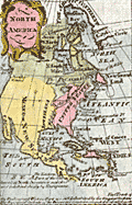 | Details | Anonymous | 1790 |
| Fine pair miniature maps North America South America |
|
Anonymous |
|
| 1790 |
| LOC:13 |
| $165.00 | Anonymous | Fine-pair-miniature-maps-North-America-South-America | Fine pair of miniature maps of North America and of South America. Each charming antique, hand-colored map measures 2" x 3.5" inside the neatline. With minuscule text in English describing each continent. Anonymous. Shows Nootka Sound. Date estimated ca. 1790 but certainly between 1778 and 1803.
<br></br>
Most of the western U.S.A. is labeled as Mexico or New Spain or as Louisiana. Page numbers 5 and 6. |
| 124 |  | Details | Anonymous | 1795 |
| External and Internal Views of a first rate Ship of War. |
|
Anonymous |
|
| 1795 |
| LOC:1 |
| $165.00 | Anonymous | External-and-Internal-Views-of-a-first-rate-Ship-of-War- | A detailed copperplate engraving of a first rate British 'line of battle' ship with 3 gun decks. Shows full rigging and a below-decks cross-section. Includes detailed insets of the sail plan, yard rigging and the ship's chain pump. A good find as many similar ship views are steel-plate engravings that lack the character and warmth of this fine late 18th century example.
<br></br>
From Hall's Encyclopedia. |
| 964 | 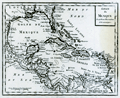 | Details | Anonymous | 1800 |
| Antique map of the Gulf of Mexico and Caribbean Sea |
|
Anonymous |
|
| 1800 |
| LOC:0 |
| $0.00 | Anonymous | Antique-map-of-the-Gulf-of-Mexico-and-Caribbean-Sea | SOLD <br></br>
Antique copper-plate engraved map of the Caribbean, <b>Gulf of Mexico</b>, Central America and portions of Colombia and Venezuela. This original old map ca. 1800 shows Florida as an archipelago of islands as well as the key cities of Havana, Cuba; Saint Augustine and Pensacola, Florida; Mobile, Alabama; <b>New Orleans, Louisiana</b>; and Port-Royal, Jamaica. Because the wide area encompassing the Louisiana Purchase is labeled as "Louisiana" we can date the map to prior to 1803, the date of that transaction.
<br></br>
After a map produced by J.B. Nolin for his "<i>Atlas Général a l'usage des colleges et maisons d'education</i>". Plate 25, |
| 5198 | 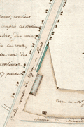 | Details | Anonymous | 1800 |
| Two French Manuscript Cadastral Plans near Dijon, France. |
|
Anonymous |
|
| 1800 |
| LOC:77 |
| $165.00 | Anonymous | Two-French-Manuscript-Cadastral-Plans-near-Dijon--France- | Two manuscript cadastral plans of lands in France belonging to Mr. Jacob, one with grape vines, ca. 1790. Today there are at least two wine producers operating in France with the name Jacob. Both wineries lie about 30 km southwest of Dijon, France near the main road : Domaine Jacob and Domaine Lucien Jacob.
<br></br>
<div class="indenttextblocksingle">
1) MS plan of an L-shaped lot belonging to Mr. Jacob and containing 49 ares and 49 centiares. Site plan was located at the intersection of the "Grande route de Dijon a Paris" and the "Chemin de Memont a Dijon." North oriented to the right with a fine arrow direction indicator. 8" x 6". </br>
2) MS plan of two lots belonging to Mr. Jacob. One lot planted with grapevines. 7" x 5".
</div>
</br>
A French "are" was a metric measurement equal to 100 square meters; a "centiare" was equal to one square meter. Usage of ares and centiares dates the map after the French Revolution, when France adopted the Metric System of measurement. |
| 5169 |  | Details | Anonymous | 1800 |
| Antique plan of the intended navigable canal from Leeds to Selby. |
|
Anonymous |
|
| 1800 |
| LOC:64 |
| $800.00 | Anonymous | Antique-plan-of-the-intended-navigable-canal-from-Leeds-to-Selby- | <br>Unrecorded map</b> ca. 1774 (but printed early 19th C.?) of a proposed canal in England from the town of Leeds to Selby. Probably after the survey of John Longbotham who is reported to have been employed to survey the route.
<br></br>
The Leeds and Selby Canal would connect with another waterway, the Leeds to Liverpool Canal, then under construction. The canal was proposed to reduce the time and costs to ship bulky items between the two towns which were currently served by boats over the winding course of the River Aire.
<br></br>
The canal proposal ultimately was defeated in Parliament and the shorter Selby Canal was built to Haddesley on the Aire in 1778.
<br></br>
Similar to but much larger (28" x 13") than an anonymous map of the same name published in the Gentleman's Magazine in 1774 (~ 8" x 13"). With two tables of distances, a table of references to the River Calder and a table of references to the River Aire.
<br></br>
Fine circular inset context map centered on York showing the towns, villages and waterways. Title on the inset reads:
<div class="indenttextblocksingle">
"A map of 40 miles round York shewing the advantageous situation of that city in a fertile country abounding with every convenience for the support of trade which would be greatly improved from the center to the utmost limits by making a canal navigation from Leeds to Selby."
</div>
</br>
On wove paper, with evident platemark. Unattributed. |
| 434 |  | Details | Anonymous | 1804 |
| The Mariner |
|
Anonymous |
|
| 1804 |
| LOC:0 |
| $0.00 | Anonymous | The-Mariner | SOLD
<br></br>
Small etching depicting a British sailor holding an octant, titled "The Mariner". From "The Book of Trades, or Library of the Useful Arts"; Part 1. Published by Tabart & Co. London 1804. Matted with archival materials. |
| 435 |  | Details | Anonymous | 1804 |
| The Shipwright |
|
Anonymous |
|
| 1804 |
| LOC:0 |
| $0.00 | Anonymous | The-Shipwright | <BR> </BR>
SOLD
<BR> </BR>
Small etching depicting a British ship-yard worker with a caulking hammer at work pounding pegs into the hull of a wooden vessel. Titled "The Shipwright" this 200+ year old work is from "The Book of Trades, or Library of the Useful Arts"; Part 1. Published by Tabart & Co. London 1804. Matted with archival materials. Overall size with the mat is about 8"x10". |
| 5348 | 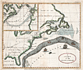 | Details | Anonymous | 1806 |
| Original antique Ben Franklins Chart of the Gulf Stream |
|
Anonymous |
|
| 1806 |
| LOC:11 |
| $0.00 | Anonymous | Original-antique-Ben-Franklins-Chart-of-the-Gulf-Stream | SOLD<br></br>
Decorative antique chart of the Gulf Stream with the Florida East and West Territories. After Benjamin Franklin's original chart, first engraved by James Poupard, published by the American Philosophical Society in 1786.
<br></br>
This chart lacks the written <b>sailing directions</b> in Poupard's engraving or "Remarks upon the navigation from Newfoundland to New York in order to avoid the Gulph Stream on the one hand, and on the other the Shoals that lie to the southward of Nantucket and of St. George's Banks." In those remarks, Franklin notes the time savings mariners can achieve through avoiding the Gulf Stream when westbound from England to the USA :
<div class="indenttextblocksingle">
"The Nantucket captains who are acquainted with this stream, make their voyages from England to Boston in as short a time generally as others take in going from Boston to England, viz. from 20 to 30 days."
</div>
</br>
Source: The Complete Works on Philosophy, Politics and Morals of the Late Dr. Benjamin Franklin, 2nd ed, London 1806. Plate VII. Vol 2. p. 197. Published by Longman, Hurst, Rees, and Orme. London, April 1, 1806. |
| 348 | 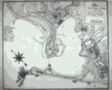 | Details | Anonymous | 1808 |
| Manuscript Map of Cadiz |
|
Anonymous |
|
| 1808 |
| LOC:0 |
| $0.00 | Anonymous | Manuscript-Map-of-Cadiz | Sold<BR> </BR>
Antique French pen and ink manuscript map of Cadiz, Spain ca. 1808. Scale: "Une mille." Interestingly, for a map associated with a naval officer, there is little hydrographic detail or soundings as there might be in a nautical chart , but instead a great deal of topographic detail about the surrounding area. Fourteen key locations are noted by lettering and described by a legend at the left of the map. Decorative compass rose denotes north to the upper left. |
| 4940 |  | Details | Anonymous | 1809 |
| Manuscript chart of the island of Diego Garcia |
|
Anonymous |
|
| 1809 |
| LOC:200 |
| $975.00 | Anonymous | Manuscript-chart-of-the-island-of-Diego-Garcia | French manuscript chart of the island of Diego Garcia. Diego Garcia, a coral atoll, is the largest and southernmost member of the Chagos Archipelago, in the central Indian Ocean.
<br/><br/>
Dated on or near May 2, 1809 when the French Governor of Mauritius Decaen granted rights over the island to Cayeux, the Didier brothers, and Lapotaire. Lapotaire was reported to have over 100 slaves working his copra plantation in 1809. The map clearly shows those three land holdings, with Didier at the southern end of the island. (Cawley, Charles. Colonies in Conflict: The History of the British Overseas Territories. Cambridge Scholars Publishing. 2015.)
<br/></br/>
"Portuguese explorers discovered Diego Garcia in the early 1500s. The islands remained uninhabited until the 18th century when the French established coconut and copra plantations with the help of slave labor. Diego Garcia became a possession of the United Kingdom after the Napoleonic wars, and from 1814 to 1965, it was a dependency of Mauritius."
(Source: https://www.cs.mcgill.ca) |
| 671 |  | Details | Anonymous | 1820 |
| Blank shipping document from du Roveray and Company of Havre |
|
Anonymous |
|
| 1820 |
| LOC:1 |
| $195.00 | Anonymous | Blank-shipping-document-from-du-Roveray-and-Company-of-Havre | Rare blank maritime shipping document dates from 1820's from du Roveray & Co. of Havre, France. With an image of a sailing ship at upper left. This template shipping document was designed so that the shipper could enter pertinent standard contractual information in the blank areas: ship's name, master's name, destination, recipients name, freight rate, number of bills of lading, and date.
<br></br>
The engraved document begins <div class="indenttextblock">"Shipped in good order and well-conditioned by DU ROVERAY & Co. of Havre; in and upon the good [blank] called the [blank] whereof is Master, for this present voyage [blank] now riding at anchor in the Port of Harve, & bound for [blank] to say [blank] …"<div> |
| 5358 |  | Details | Anonymous | 1822 |
| Notable manuscript Louisiana map - early 19th |
|
Anonymous |
|
| 1822 |
| LOC:200 |
| $325.00 | Anonymous | Notable-manuscript-Louisiana-map---early-19th | A notable manuscript map of Louisiana by, according to the seller, "a schoolgirl" in Tallmadge, Ohio. Sold from a lot of other maps, one with the attribution: "Tallmadge [Ohio ?] Febr. 7, 1822". The map is notable for the inaccuracies, archaic place names, and a surprising included waterway.
<br></br>
First, the inaccuracy. The land west of the Sabine River, or Texas, was not a British Dominion. In 1822, after Mexico gained independence from Spain a year earlier, the land was Mexican Texas.
Second, in 1817 the State of Mississippi was admitted to the Union. The Mississippi Territory was divided into the State of Mississippi and State of Alabama (1819).
<br></br>
Finally, it is very surprising to see the Iberville River (Bayou Manchac) on this map. Today, Bayou Manchac is a shallow eighteen mile long Bayou but when the French arrived in Louisiana the waterway was the "rivière d'Iberville", an important channel in the area's transportation network. In 1814 Bayou Manchac was closed to the Mississippi and was no longer navigable. |
| 2567 | 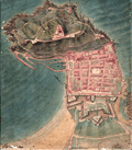 | Details | Anonymous | 1823 |
| Manuscript Plan of San Sebastian, Spain. Basque region |
|
Anonymous |
|
| 1823 |
| LOC:0 |
| $0.00 | Anonymous | Manuscript-Plan-of-San-Sebastian--Spain--Basque-region | SOLD
<BR> </BR>
Manuscript plan of San Sebastian, Spain a resort town on the Bay of Biscay.
<br></br>
Anonymous manuscript pen and ink plan of shows a well-fortified cape jutting into a body of water. Military orientation and focus. Much small fine detail. Many important places are numbered but no legend is present. French text.
<br></br>
A structure overlooks a fortified town, several batteries, and a small protected harbor. In text is the obscured author's name beginning with letter "P", date "1823", the scale "1/5000". The three identified location descriptions read "Redoute du Rondeau" and "Batterie St. Elme" and "Aqueduc". |
| 2566 | 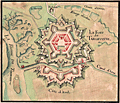 | Details | Anonymous | 1840 |
| The Mystery of le Fort de Tarlevinne |
|
Anonymous |
|
| 1840 |
| LOC:77 |
| $750.00 | Anonymous | The-Mystery-of-le-Fort-de-Tarlevinne | A pen and ink, manuscript plan of the Fort of Tarlevinne. French text. Location unknown. Original, attractive hand-coloring.
<br></br>
I am stumped on this one! A Google search on 'Tarlevinne' returns no results that tell us where the fort is located, if indeed it existed at all. Regardless of location, the creator put much effort and time into this small manuscript fortress plan.
<br></br>
A Vauban-style fort near "la Riviere de Tirenard" (a native French speaker suggests the interpretation of Tirenard is "little Fox River.") From the river a canal funnels the river's flow through a "port" with a set of locks ("Ecluse") into the "Canal d'Arne".
<br></br>
One location somewhat fits the plan of Tarlevinne, but is not completely convincing. Near Livorno, Italy where the Canale Imperiale connects the Arno River to the port. "Riviere de Tirenard" could refer to a river emptying into the Tyrrhenian Sea. |
| 1223 | 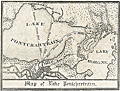 | Details | Anonymous | 1840 |
| Uncommon antique Map of Lake Pontchartrain |
|
Anonymous |
|
| 1840 |
| LOC:3 |
| $200.00 | Anonymous | Uncommon-antique-Map-of-Lake-Pontchartrain | Uncommon and unrecorded version of a lithographed map ca. 1840 of <b>Lake Pontchartrain</b> in Louisiana with three steamboat routes shown: to Madisonville, La., to Mandeville, La. and a mail steamboat route to Mobile, Alabama. Possibly by L. Hirt.
<br></br>
In 1834 it was reported that mail service was provided through three weekly round-trips between New Orleans and Mobile at a total annual cost of <a href="https://books.google.com/books?id=VfcaAAAAYAAJ&pg=PR1&dq=mail+steam+boat+mobile+new+orleans&source=gbs_selected_pages&cad=3#v=onepage&q=mail%20steam%20boat%20mobile%20new%20orleans&f=false" target="_blank">$40,000.</a></a>
<br></br>
This map appears as a vignette in L. Hirt's 1841 " Plan of New Orleans with Perspective and Geometrical Views of the Principal Buildings of the City" from <a href="http://louisdl.louislibraries.org/cdm/ref/collection/p15140coll28/id/76" target="_blank"> The Historic New Orleans Collection.</a> The present map shows signs of being disbound from a smaller volume. Scale: 3 inches to the mile. Louisiana History.
<br></br>
The map features Lake Borgne, Bayou Sauvage, and Bayou Bienvenue. Three steamboat routes terminate at Milneburg, at the north end of the Ponchartrain Rail Road on the south shore of Lake Pontchartrain. The Pontchartrain Rail-Road, the first railway in New Orleans, Louisiana began service in 1831. The route of the railway ran down the center of Elysian Fields Avenue from the Faubourg Marigny to the port of Milneburg, later the Lake Pontchartrain Amusement Park.
<br></br>
This scarce small map shows the city of New Orleans with Bayou St. John, the New Orleans canal, and the Carrolton Railroad. |
| 1224 | 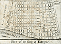 | Details | Anonymous | 1840 |
| Scarce antique map of New Orleans Tenth Ward or the City of Lafayette |
|
Anonymous |
|
| 1840 |
| LOC:3 |
| $250.00 | Anonymous | Scarce-antique-map-of-New-Orleans-Tenth-Ward-or-the-City-of-Lafayette | Unrecorded version of an early wood-cut map of <b>New Orlean's Tenth Ward</b> circa 1840 when it was known as <b>Lafayette City</b>. Earlier, during the French period New Orlean's Tenth Ward was known as the Faubourg Lafayette. Boundaries of Lafayette City include the Mississippi River, Felicity Street, Nayades Street (later known as St. Charles Avenue), and a large tract owned by R. A. Delachaise. Shows the New Orleans and Carrollton Railroad connecting the city of New Orleans to then then distant resort village of Carrollton.
<br></br>
Possibly by L. Hirt, and derived or re-purposed from his larger work. This map appears as a vignette in L. Hirt's 1841 " Plan of New Orleans with Perspective and Geometrical Views of the Principal Buildings of the City" from <a href="http://louisdl.louislibraries.org/cdm/ref/collection/p15140coll28/id/76" target="_blank"> The Historic New Orleans Collection.</a> The present map shows signs of being disbound from a smaller volume. Scale: 3 inches to the mile. Louisiana History.
<br></br>
Faubourg Lafayette was founded with small settlements around steamboat landings in New Orleans. The faubourg became the City of Lafayette, then part of Jefferson Parish and its first parish seat. Lafayette was a separate municipality until it was incorporated into New Orleans, Orleans Parish, in 1852. The present boundaries of the Tenth Ward include St. Charles Avenue, Jackson Avenue, the Pontchartrain Expressway, and Simon Bolivar Avenue. <a href="https://en.wikipedia.org/wiki/Faubourg_Lafayette" target="_blank"> (Source.)</a> |
| 3636 | 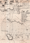 | Details | Anonymous | 1844 |
| Rare antique chart of the Port of Goa and Mormugao, India |
|
Anonymous |
|
| 1844 |
| LOC:0 |
| $0.00 | Anonymous | Rare-antique-chart-of-the-Port-of-Goa-and-Mormugao--India | SOLD<br></br>
Scarce Portuguese chart of the Port of Goa, on the southwest coast of India. which was under Portuguese rule from 1510 to 1961. By Antonio Lopes da Costa Almeida (1784-1859), barão de Reboredo. Among his many credits Antonio da Costa Almeida was associated with the Academy of Guardas-Marinhas and the Naval Artillery.
<br></br>
The most interesting portion on this lithographed antique chart are the eight charming and naïve elevation views placed at the top of the print. These views include: Vistas das casas das Freiras, Vistas das casas de D. Joanna, and Vista das cruz du Betim.
<br></br>
Our chart, "Carta Hydrographica do Porto de Goa e Entrada das Barras de Agoada de Mormugao", was printed in 1844 just one year after the Portuguese moved the capital to Panaji from Velha Goa. By the mid-18th century, Portuguese Goa had expanded to most of the present-day state limits.
<br></br>
Key topographic features on the chart include Panaji, the Mandovi River, Zauri River, Provincia de Salcette, and Provincia de Bardez. Seventeen important locations on the map are identified alphabetically on the chart and are explained in a legend at right.
<br></br>
Our chart of Goa accompanied the work: "Esclarecimentos Hydrographicos para intelligencia e uso do Plano dos Portos de Goa e Mormogao" in Annaes Maritimos e Colonias. Quinta Serie. No 7, 1844, Lisboa. Lithographed in 1844 by A.C. Lemos, Largo do Quintella no. 1. Lisbon. |
| 749 |  | Details | Anonymous | 1846 |
| Antique Manuscript Playbill from the East India Company Ship Herefordshire |
|
Anonymous |
|
| 1846 |
| LOC:1 |
| $2,100.00 | Anonymous | Antique-Manuscript-Playbill-from-the-East-India-Company-Ship-Herefordshire | Very unusual and scarce manuscript theatrical playbill from a known British East India Company trading ship dated within at January 23, 1846.
<br></br>
On long voyages in order to entertain passengers, ships would sometimes offer music, dancing, and plays to make the tedious journey more enjoyable. This rare survivor documents such a theatrical offering aboard the East Indiaman "Herefordshire" as it returned from a voyage that began in London in 1845 and terminated in Bombay, India on Feb. 28, 1846 [1].
<br></br>
The Herefordshire was an old 40-gun, 1600 ton teak-built ship of the East India Company, launched in Bombay in 1812 by John Money. Her Captain was George Richardson.
<br></br>
This rare playbill reads: "THEATRE ROYAL of the HEREFORDSHIRE Under the Distinguished Patronage of the LADIES & CAPTAIN RICHARDSON Jan 23rd 1846. This Evening her Majesty's Servants will perform a New Drama entitled the PENRYN TRAGEDY, with New Scenery, Dresses, &c. </br>
...</br>
...</br>
Act 1st Scene 1st</br>
The Sailors of HER MAJESTY's SHIP Britannia making merry in the Green Dragon.</br>
...</br>
...</br>
The Whole to Conclude with the Popular Farce BILLY BUTTON the TAILOR
...</br>
..</br>
Doors open at 6 o'clock. Performance to commence at 7. For tickets of Admission apply to Mr. Maynard, Stage Manager No. 9 Starboard Terrace, Capstan Square, Gun deck road.
…
<br></br>
This rare, unusual and interesting piece of nautical ephemera should interest collectors of both the theater and nautical history. It is a document from the end of the East India Company's control of India. The East India Company dissolved in 1858 with Britain exerting direct control after the India Rebellion of 1857. Watermarked "Ward and Son. 1842."
<br></br>
[1] "Allen's Indian Mail and Register of Intelligence for British and Foreign India." 1845 and 1846.
</br>
[2] Berncastle, Julius. "A Voyage to China". William Shoberl. London, 1850. |
| 169 |  | Details | Anonymous | 1849 |
| SOLD Reconnaissance of Pensacola and Perdido Bays |
|
Anonymous |
|
| 1849 |
| LOC:0 |
| $0.00 | Anonymous | SOLD-Reconnaissance-of-Pensacola-and-Perdido-Bays | SOLD<BR> </BR>
Small coastal survey chart of Florida from Bonsecour Bay to the East end of Santa Rosa Island. |
| 2487 |  | Details | Anonymous | 1851 |
| Mount Auburn Cemetery |
|
Anonymous |
|
| 1851 |
| LOC:0 |
| $0.00 | Anonymous | Mount-Auburn-Cemetery | SOLD
<br></br>
Mount Auburn Avenues and Paths. Boston 1851 Vintage Map. Collectible. Fabric Bkg |
| 7936 | 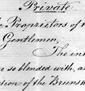 | Details | Anonymous | 1852 |
| Manuscript investment prospectus for the Brunswick Canal Company |
|
Anonymous |
|
| 1852 |
| LOC:41 |
| $0.00 | Anonymous | Manuscript-investment-prospectus-for-the-Brunswick-Canal-Company | SOLD<br><br>This manuscript private letter to the Proprietors of the City of Brunswick, Georgia signed by D. L. Martin and Charles L. Muir, belongs to the final stage of the long and troubled effort to complete the Brunswick Canal in Georgia. It was written at a moment when the work was nearly finished but paralyzed for lack of money. The six-page document pleads with northern and local investors to cooperate, arguing that the city’s real-estate holdings and the canal’s success were inseparable. Without the canal, Brunswick’s fine harbor and well-laid streets remained idle capital; with it, the authors promised, the town would spring to life and the stock of both companies would rise to par.
<br><br>
The letter fits precisely with newspaper reports from 1852 describing a new bond issue for the Brunswick Canal and Rail Road Company. Those public notices named D. Randolph Martin, president of the Ocean Bank of New York, as trustee for $100,000 in second-mortgage seven-percent bonds. In the private appeal, “D. L. Martin” is almost certainly the same man, acting both as financial organizer and trustee. His participation through Ocean Bank linked the Georgia enterprise to New York capital markets, where southern infrastructure bonds were commonly sold under northern trusteeship to reassure investors.
<br><br>
Technically, the canal was a modest work—about nine miles long, four feet deep, and fifty feet wide—but its promoters claimed it would open four thousand miles of interior river navigation, connecting the Altamaha system to the Atlantic at Brunswick. They argued that it would unleash trade in timber, cotton, and naval stores, and they projected annual revenues of up to seventy-five thousand dollars. The letter describes contracts already arranged with Dr. Robert Collins of Macon to finish the remaining excavation at thirty cents per cubic yard, estimating that thirty-five thousand dollars would complete the job.
<br><br |
| 382 |  | Details | Anonymous | 1853 |
| Lake Pontchartrain Harbour and Breakwater |
|
Anonymous |
|
| 1853 |
| LOC:10 |
| $225.00 | Anonymous | Lake-Pontchartrain-Harbour-and-Breakwater | Fascinating plan of the southern shore of Lake Ponchartrain in New Orleans, Louisiana from 1853. During that era both Bayou St. John and the New Canal (the present <a rel="nofollow" target="_blank" href="http://en.wikipedia.org/wiki/17th_Street_Canal">17th Street Canal</a>) were navigable to small vessels; a lighthouse is shown at the mouth of each canal. The plan shows projected construction of wooden breakwaters in the lake that were designed "to furnish safe anchorage in front of the termini of the Pontchartrain Railroad, Bayou St John, and New Canal…".<BR> </BR>
Other depicted features include Milneburg, then a suburb of New Orleans connected to it by the Pontchartrain Railroad, two lighthouses, and the Jefferson and Lake Pontchartrain Railroad in what is now Jefferson Parish. Construction details of the wooden breakwater are shown in profile and elevation. <BR> </BR>
Today neither of the two railroad lines linking New Orleans to the Lakefront exist. Neither Bayou St. John nor the 17th Street Canal (a large drainage ditch) are navigable. In fact a section of the 17th Street Canal failed after Hurricane Katrina and was responsible for flooding a large part of New Orleans and at least 31 deaths. The deadly breach in the canal can be located on the plan near the bottom of the shaded high land directly adjacent to the New Canal. <BR> </BR>
Dated October 30th, 1853. Printed by Wagner and Mc Guigan Lithographers, Philadelphia. For reference see: |
| 465 | 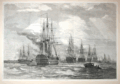 | Details | Anonymous | 1858 |
| The British Fleet at Spithead |
|
Anonymous |
|
| 1858 |
| LOC:0 |
| $0.00 | Anonymous | The-British-Fleet-at-Spithead | SOLD<br></br>
Very attractive woodblock engraving. Panoramic view shows warships from the British Navy under review at Spithead near the Isle of Wight at an early period in the transition from sail to steam power. Archivally matted. Dimensions with the mat are approx. 26" W x 20" H. Pages 146 and 147. From the London Illustrated News August 14, 1858. |
| 2564 | 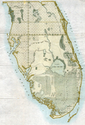 | Details | Anonymous | 1858 |
| Map of the Florida Peninsula |
|
Anonymous |
|
| 1858 |
| LOC:87 |
| $180.00 | Anonymous | Map-of-the-Florida-Peninsula | Very attractive antique map of the Florida Peninsula from 1858. Shows status of surveys below the 2nd basis parallel conducted to that date. |
| 4909 |  | Details | Anonymous | 1859 |
| Antique manuscript plat Queens, New York deBevoise |
|
Anonymous |
|
| 1859 |
| LOC:200 |
| $500.00 | Anonymous | Antique-manuscript-plat-Queens--New-York-deBevoise | One of a kind manuscript map ca. 1859 of a plat of land in the city of Newtown, borough of Queens, New York. Newtown was founded as Middenburgh by the Dutch in 1652. In the 17th century Dutch colony of New Netherland, Newtown was a suburb of New Amsterdam, and was renamed "Elmhurst" in 1897.
<br></br>
Shows a tract of woodlands, owned by farmer Abraham de Bevoise. Contains surveyors' field notes including the metes and bounds [1] of the plat relating it to land owned by Theodorus Kolyer (d. 1854). A fine, piece with a simple, pastoral view of the woodlands owned by de Bevoise, totaling two acres and 4 perches. A perch is a unit of area equal to 1/160 of an acre.
<br /> <br />
Abraham de Bevoise (1819 - 1887) was a farmer originally of French Huguenot ancestors.
<br /> <br />
<div class="indenttextblocksingle">
[1] The term "metes" refers to a boundary defined by the measurement of each straight run, specified by a distance between the terminal points, and an orientation or direction. A direction may be a simple compass bearing, or a precise orientation determined by accurate survey methods. The term "bounds" refers to a more general boundary description, such as along a certain watercourse, a stone wall, an adjoining public road way, or an existing building. (Online Source: https://definitions.uslegal.com/m/metes-and-bounds/)
</div> |
| 4923 | 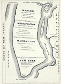 | Details | Anonymous | 1863 |
| Grand Gas-light Combination of the Metropolis of America |
|
Anonymous |
|
| 1863 |
| LOC:13 |
| $550.00 | Anonymous | Grand-Gas-light-Combination-of-the-Metropolis-of-America | Map representing five gas-light companies that served New-York City in 1863:
<div class="indenttextblocksingle">
<ul style="list-style-type: circle;">
<li>Harlem Gas Light Company</li>
<li>Metropolitan Gas Light Company</li>
<li>Manhattan Gas Light Company</li>
<li>New York Gas Light Company</li>
<li>Citizens' Gas-light Company</li>
</ul>
</div>
Published in the American Gas Light Journal, March 2, 1863. p. 265 |
| 5308 | 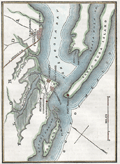 | Details | Anonymous | 1863 |
| Civil War era map Santa Rosa Island and Pensacola Florida |
|
Anonymous |
|
| 1863 |
| LOC:11 |
| $175.00 | Anonymous | Civil-War-era-map-Santa-Rosa-Island-and-Pensacola-Florida | Small hand-colored map of Santa Rosa Island and Pensacola Bay, Florida. Published before the end of the U. S. Civil War.
<br></br>
This fine map illustrates the fall of Pensacola to Rebel forces in "The History of the Civil War in America …" by John S. C. Abbott. Published in 1863 from Springfield, Massachusetts. Volume 1. Page 359.
<br></br>
<b>Includes the noted locations of these key features:</b>
<div class="indenttextblocksingle">
<ul style="list-style-type: circle;">
<li>Pensacola, Florida</li>
<li>Gulf of Mexico</li>
<li>Fort Barrancas </li>
<li>Fort McRae</li>
<li>Fort Pickens</li>
<li>Fort St. Miguel</li>
<li>Navy Cove</li>
<li>Warrington, Florida</li>
<li>Woolsey, Florida</li>
<li>Deer Point</li>
<li>Fair Point</li>
<li>Foster's Island</li>
<li>Pensacola Bay</li>
<li>Santa Rosa Island</li>
<li>Santa Rosa Sound</li>
<li>Bayou Chico</li>
<li>Bayou Grande</li>
<li>Grand Lagoon</li>
</ul>
</div>
Fort Pickens, located on the western tip of Santa Rosa Island in the Florida Panhandle, played a significant role in the United States' coastal defense system during the period from 1850 to 1870. The fort's strategic location allowed it to control the entrance to Pensacola Bay .
<br><br>
During the Civil War (1861-1865), Fort Pickens remained under Union control, despite Florida's secession from the United States in 1861. On January 12, 1861, just days before Florida officially seceded from the Union, a group of Florida state troops and local militia demanded the surrender of the Pensacola Navy Yard. The Union commander, Commodore James Armstrong, surrendered the yard to the Confederates without a fight. The Union forces, however, maintained control over Fort Pickens, located on Santa Rosa Island, which guarded the entrance to Pensacola Bay. Fort Pickens served as a base for Union operations along the Gulf Coast, and its presence helped to disrupt Confederate shipping and supply lines. |
| 4915 |  | Details | Anonymous | 1863 |
| MS Civil War map St. Augustine Florida |
|
Anonymous |
|
| 1863 |
| LOC:0 |
| $0.00 | Anonymous | MS--Civil-War-map-St--Augustine-Florida | SOLD
<br></br>
Manuscript map of St. Augustine Florida ca. 1863. The lighthouse is the old light, not used after 1874.
<br></br>
Under magnification, notations on the map identify positions of Union forces- the 7th Connecticut near the Hospital, and the 7th New Hampshire volunteers at the entrenchments where the full description reads “Entrenchments thrown up by the 7th N.H. Vol.” With online sources we can tie the seventh New Hampshire to St Aug from September 3, 1862 to May 10, 1863. The Seventh Connecticut was in St. Aug from April 13, 1863 to August 2, 1863. |
| 993 |  | Details | Anonymous | 1866 |
| Steamboat Bill of Lading for Valence Plantation |
|
Anonymous |
|
| 1866 |
| LOC:1 |
| $500.00 | Anonymous | Steamboat-Bill-of-Lading-for-Valence-Plantation | Rare post civil war shipping document, a "Bill of Lading", for the steamboat <b>Belle Ida</b> to transport items from New Orleans, Louisiana to Valence Plantation, along Bayou Lafourche, in Assumption Parish. <b>Valence Plantation</b> was most likely located near the current-day town of Supreme, just a few miles south of the well-known Madewood Plantation and Naploeonville, Louisiana. Dated within to February 9th, 1866. The bill of lading was filled in by hand at time of shipping and is addressed to J.B. Savage, Valence Plantation, Bayou Lafourche.
<br></br>
Bayou Lafourche has not been navigable from the Mississippi River since 1905 when a dam was built at Donaldsonville, La. but prior to that time the waterway served as an important commercial artery.
<br></br>
The Belle Ida was likely a stern-wheel steamboat built in 1861 (Wooldridge Steamboat List. <a href="https://www.umsl.edu/mercantile/collections/pott-library-special-collections/assets/pdf/collections/Woold_Ridge_Steamboat_list.pdf" target="_blank">Internet </a>). With a stock logo of a side-wheel steamboat by T. Fitzwilliam, Stationer and Printer, 76 Camp Street, N.O.
<br></br>
Symonds, Courtney and Co. were Tobacco Factors and General Forwarding and Commission Merchants located at No. 35 Natchez Street, New Orleans, LA. With a glued 2 cent stamp within. Addressed on verso.
<br></br>
The items shipped from New Orleans by Symonds Courtney and Co. included:
<ul style="list-style-type: none;">
<li>1 sack of harnesses</li>
<li>1 bundle of bridles</li>
<li>5 cases of sundries</li>
<li>10 head of mules</li>
<li>1 horse</li>
<ul/> |
| 6383 |  | Details | Anonymous | 1866 |
| Manuscript cadastral map of the Commune de Lovagny |
|
Anonymous |
|
| 1866 |
| LOC: |
| $100.00 | Anonymous | Manuscript-cadastral-map-of-the-Commune-de-Lovagny | manuscript map of the commune of Lovagny in the Haute-Savoie department in the Auvergne-Rhône-Alpes region in south-eastern France. |
| 1272 | 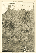 | Details | Anonymous | 1866 |
| Antique Birds Eye View of the Mississippi Basin |
|
Anonymous |
|
| 1866 |
| LOC:0 |
| $0.00 | Anonymous | Antique-Birds-Eye-View-of-the-Mississippi-Basin | SOLD
<br></br>
Unusual post-war antique wood engraving of a birds eye view of the <b>Mississippi basin</b> with numerous rivers, roads and cities identified by name. With this image the viewer looks at the landscape from a new perspective with South at the top of page. Attractive.
<br></br>
<div class="indenttextblock"> "Wood engraving is a printmaking and letterpress printing technique, in which an artist works an image or matrix of images into a block of wood. Functionally a variety of woodcut, it uses relief printing, where the artist applies ink to the face of the block and prints using relatively low pressure. By contrast, ordinary engraving, like etching, uses a metal plate for the matrix, and is printed by the intaglio method, where the ink fills the valleys, the removed areas. As a result, wood engravings deteriorate less quickly than copper-plate engravings, and have a distinctive white-on-black character." (Source: <a href="https://en.wikipedia.org/wiki/Wood_engraving" target="_blank">INTERNET</a> )
</div>
<BR/>
Coverage extends from St. Louis to the Gulf of Mexico and beyond with dozens of cities and town noted including Austin, Texas; Key West, Florida; New Orleans, Louisiana; Brownsville, Galveston, Montgomery, Jackson, Knoxville, Charleston, Savannah, Vicksburg, Natchez and many more.
<br></br>
Includes the Mississippi River, Missouri River, Ohio River, Arkansas River, Savannah River, Chattahoochee River, Escambia River, and the upper Gulf of Mexico. Published in 1866 by Harpers for the "Pictorial History of the Civil War" part 1. |
| 4775 |  | Details | Anonymous | 1870 |
| Antique Chart Fragment of Chesapeake Bay |
|
Anonymous |
|
| 1870 |
| LOC:0 |
| $0.00 | Anonymous | Antique-Chart-Fragment-of-Chesapeake-Bay | SOLD<br /><br />Interesting antique fragment covering lower Chesapeake Bay cut from a large 19th-century nautical chart. This relic, formerly an inset chart in a much larger rolled sea chart, shows the entrance to Chesapeake Bay with parts of Virginia and Delaware.
<br></br>
Contains many interesting pencil manuscript compass bearings off the <b>Cape Henry lighthouse</b> which was the first such navigational aid to be built in the Chesapeake Bay. Built in 1792 at a cost of $24,076 the light at Cape Henry burned tuna fish oil, whale oil, colza oil, and lard oil. The light was only updated to burn kerosene in 1859 after petroleum oil was found in Pennsylvania. (Morrison and Hansen. Charting the Chesapeake).
<br></br>
As stated in the title, the topographic and hydrographic detail is from the U.S. Coast Survey, therefore this was likely a privately published chart. Coastal outline is very dark, suggesting that the author was George Eldridge.
<br></br>
Dated probably to the last half of the 19th century. The Willoughby Spit Lightship, off the entrance to Hampton Roads, has been crossed out in pencil. A bit of research reveals that in 1872 the lightship was replaced with what is now the Thimble Shoals light. That fact suggests the source chart was printed before 1872 and used at sea after 1872. |
| 1164 |  | Details | Anonymous | 1880 |
| Antique trade card for the sloop yacht Emma Wicks |
|
Anonymous |
|
| 1880 |
| LOC:0 |
| $0.00 | Anonymous | Antique-trade-card-for-the-sloop-yacht-Emma-Wicks | SOLD
<br></br>
Rare antique lithographed trade card for the sloop yacht "Emma Wicks" ca. 1880. Captain Charles Adams & Jason Wicks advertised that "parties desiring a pleasant sail on the ocean or bays or to Cape May, or Long Beach will be cheerfully accommodated."
<br></br>
The illustration is of a moonlit night regatta of small gaff-rigged <b>catboats</b> off Long Island Light, Boston Harbor. Catboats are characterized by their simplicity, ease of handling, shallow draft, and large capacity. Historically, the origin of the catboat type was in New York around 1840. Cat-rigged boats were used for fishing and transport in the coastal waters around Cape Cod, Narragansett Bay, New York and New Jersey. Size is about 3 1/2" x 2 1/2". Verso blank. |
| 452 |  | Details | Anonymous | 1880 |
| Chart of Portions of Beaufort River |
|
Anonymous |
|
| 1880 |
| LOC:0 |
| $0.00 | Anonymous | Chart-of-Portions-of-Beaufort-River | SOLD
<BR> </BR>
Corps of Engineers hydrographic chart of several portions of the Beaufort River, near Beaufort S.C., the second oldest city in South Carolina, behind Charleston. Noted features include Battery Creek, the "site of old fort", and "site of Fort Charlotte". With depth contours and numerous soundings. Archivally matted with total size approximately 25" x 27".<BR> </BR>
Accompanied Senate doc. 195, 46th Cong., 2nd Sess. |
| 3598 |  | Details | Anonymous | 1880 |
| 19th century cadastral survey of lands near Lake Weir, Florida |
|
Anonymous |
|
| 1880 |
| LOC:0 |
| $0.00 | Anonymous | 19th-century-cadastral-survey-of-lands-near-Lake-Weir--Florida | SOLD<br></br>
19th century manuscript cadastral survey map of lands near Lake Weir and Ocklawaha, Florida, about 16 miles southeast of Ocala. Ocklawaha, on the north coast of Lake Weir is notorious as the location where the Barker-Karpis gang also known as the <b>Ma Barker gang maintained a hideout</b> at 3250 East Highway C-25. On January 16, 1935 the FBI opened fire on the house killing Ma Barker and her son Fred. The house has recently been moved off the property.
<br></br>
Surveys of the Florida Peninsula from this era are scarce.
<br></br>
Named locations on this old survey include nearby Little Lake Weir, Bower Lake, Hamock Pond, Coon Pond, Silver Lake, Fig Lake, Saddleback Lake, Prospect Lake, and a railroad depot. Ocklawaha is not named. Dates on this MS map including 1880 and 1898 suggest usage of the map over a long period. Names of property owners include Mitchell, Cooper, Taylor, Williams, and many more.
<br></br> |
| 5199 |  | Details | Anonymous | 1880 |
| Manuscript plan of Chalon-sur-Saône, France |
|
Anonymous |
|
| 1880 |
| LOC:77 |
| $175.00 | Anonymous | Manuscript-plan-of-Chalon-sur-Saône--France | Fine manuscript pen and ink plan ca. 1880 titled: "Plan de deux enceintes primitives de Chalon sur Saone." Show the ancient city with the two ancient walls or "enceintes" at the village of Chalon-sur-Saône, France. Notes the location of many interesting sites including the "gibet" (gibbet) or post used as a gallows or place of execution.
<br></br>
With a unperforated red stamp bearing three circles ( the coat of arms of Chalon sur Saone) above the French medal Legion d'Honneur surmounted by a crown. Napoleon I awarded the Legion d'Honneur to the town of Chalon sur Saone in 1815 in recompense for their support during his Austrian campaign.
<br></br>
Top is oriented to the northeast. Shows the Saone river with bridges at right. |
| 133 | 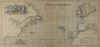 | Details | Anonymous | 1882 |
| Track Chart Norddentsher Lloyd, Bremen |
|
Anonymous |
|
| 1882 |
| LOC:0 |
| $0.00 | Anonymous | Track-Chart--Norddentsher-Lloyd--Bremen | SOLD
<br></br>
Small ship's track chart / nautical map of Atlantic Ocean produced by the Norddentsher Lloyd shipping company that was used by a passenger to track his progress on a Transatlantic cruise. Details the daily position and miles made good on a voyage from Sandy Hook, New Jersey to England between August 31 and September 8, 1887 with a Captain Richler. With an inset of a steamer underway. |
| 134 |  | Details | Anonymous | 1882 |
| Track Chart Anchor Line Transatlantic Service |
|
Anonymous |
|
| 1882 |
| LOC:0 |
| $90.00 | Anonymous | Track-Chart--Anchor-Line-Transatlantic-Service | Small antique ship's track chart of the Atlantic Ocean produced by the Anchor Line shipping company and used by passenger "Bertie Brown" to track his progress on a Transatlantic cruise. Details the daily position on a voyage from Ireland to New York departing September 29, 1882. Document on card stock folds into 3 parts. Front cover lists vessels owned by Anchor Line with their tonnage. With a profile view of a steamer underway. Expands to 10"x6". |
| 1218 |  | Details | Anonymous | 1889 |
| Boston and Gloucester Steamboat Company pass for 1888 |
|
Anonymous |
|
| 1889 |
| LOC:0 |
| $70.00 | Anonymous | Boston-and-Gloucester-Steamboat-Company-pass-for-1888 | An antique Boston and Gloucester Steamboat Company annual pass for the year 1888. On green card stock. Issued as number 116. Valid until January 1, 1889. Ship's wheel decoration with the date "1888".
<br></br>
Boston and Gloucester Steamboat company began year round service in 1870 and continued operating between Boston and Gloucester until 1926 when they ceased operations. Steamboats from the line included the "Ella Knight", "George Chaffee", "City of Gloucester", and the "Cape Ann" a steel-hulled propeller driven vessel of 171 feet in length.
<br></br>
Text on the verso of this antique pass with rules and stipulation for use of the pass. |
| 206 |  | Details | Anonymous | 1889 |
| Brochure- Boston Gloucester Steamboat Co. |
|
Anonymous |
|
| 1889 |
| LOC:0 |
| $0.00 | Anonymous | Brochure--Boston-Gloucester-Steamboat-Co- | SOLD
<br><br/>
Highly decorative and collectible antique folding coastal map / brochure from the Boston and Gloucester Steamboat Company 1889 season. Colorful, quaint map with ships wheel decoration (far right) is a full 7" x 15" when folded out from the brochure and would frame beautifully. Map covers the coast between Boston and Portland Maine including Salem, Marblehead, Newburyport, and Cape Ann. Includes steamer schedule and pier locations. <BR> </BR>
Front cover page contains a picturesque view of a steamboat with sails underway. Two pages include descriptions of sights along the route: Swampscott, Nahant, Marblehead… One-page advertisement for a new residential development near the Gloucester harbor- Eastern Point. |
| 108 |  | Details | Anonymous | 1889 |
| Goat Island Ledge |
|
Anonymous |
|
| 1889 |
| LOC:0 |
| $45.00 | Anonymous | Goat-Island-Ledge | Corps of Engineers survey map shows Goat Island, Great Island, and Seavy's Island and a marked 'sailing course' through the nearby waters. Land areas identified through neat orange hachuring. |
| 7918 | 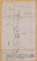 | Details | Anonymous | 1890 |
| Early surveyor's trace map of a portion of Houston near Buffalo Bayou |
|
Anonymous |
|
| 1890 |
| LOC: |
| $425.00 | Anonymous | Early-surveyor-s-trace-map-of-a-portion-of-Houston-near-Buffalo-Bayou | A rare artifact from Houston, Texas. This manuscript ink cadastral map shows the subdivisions of one-third of a league originally granted to William Perkinson, located on the north side of Buffalo Bayou, several miles west of Houston, Texas. On translucent "tracing cloth", the artifact dates ca. 1890 and was a master copy to be used for reproducing the map via blueprinting. The map identifies property owners including Settegast, Hillendahl, Harden, Bauer, and Williams, along with Turkey Creek and Cedar Island, the former a tributary of Buffalo Bayou. The tract layout includes railroad lands and State School Lands, indicating later 19th-century subdivisions.
<br><br>
The Settegast and Hillendahl families were among the earliest German settlers in the Spring Branch area near Houston. By 1848, members of these families organized one of the first Lutheran services for what became St. Peter Church in Spring Branch. Today, the area depicted lies near the Memorial neighborhood of Houston, where Turkey Creek joins Buffalo Bayou, approximately a mile south of Interstate 10 and North Eldridge Parkway.
<br><br>
Surveyor’s note at lower margin read<i>s: “Map of the subdivisions of 1/3 of a league originally granted to Wm. Perkinson situated on the North side of Buffalo Bayou about ___ miles westwardly from the City of Houston.”</i>
<br><br>Verso is inscribed with the surveyor’s catalog number “311.” |
| 5365 | 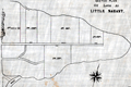 | Details | Anonymous | 1890 |
| Surveyors manuscript trace plat of Little Nahant Island, Massachusetts |
|
Anonymous |
|
| 1890 |
| LOC:13 |
| $750.00 | Anonymous | Surveyors-manuscript-trace-plat-of-Little-Nahant-Island--Massachusetts | Very rare unrecorded, manuscript surveyors' trace plat map of lots on Little Nahant Island, Massachusetts which lies north-east of Boston in Nahant Bay. The pen and ink trace, on supple surveyor's "tracing cloth" would have been used as a master to create blueprint copies.
<br></br>
Carries pencil surveyor's collation number 2013. Includes a fine late 19th century compass rose at bottom right. Estimated date ca. 1885.
<br></br>
Anonymous trace map but stylistically similar to those of W. H. Whitney from the 1890's. |
| 759 | 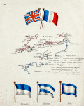 | Details | Anonymous | 1890 |
| Manuscript page with flags and a chart of British Channel |
|
Anonymous |
|
| 1890 |
| LOC:7 |
| $450.00 | Anonymous | Manuscript-page-with-flags-and-a-chart-of-British-Channel | A small manuscript chart of the English Channel. Decorated at top with the crossed flags of England and France this hand-drawn and hand-colored chart of the British Channel could have been created in the latter half of the 19th century to early 20th century by a British naval student or maritime officer candidate or quite possibly a member of the Sea Cadets Corps or its predecessor, the Naval Lads' Brigade. A legend in English describes features that would be found on a nautical chart of the period such as buoys, rocks, and bearings, but oddly the manuscript map does not contain any of those components with one exception, the Eddystone lighthouse southwest of Plymouth sound.
<br></br>
The most interesting aspect of the chart is the dotted line suggesting the route of a voyage between ports in England and France including Plymouth, Dartmouth, Torquay, Weymouth, Southampton, Sheerness, Cherbourg, and Guernsey
<br></br>
At bottom are drawn three signal flags including the Blue Peter, which was often used when preparing to leave port, or as the caption suggests, when requesting a pilot. Of the other two flags, the center flag is confirmed as a French registration flag that indicates that the vessel was registered to the Cherbourg arondissement sector between Dunkirk and Honfleur. According to Sache:
<div class="indenttextblock">
"French merchant ships had to hoist at foremast a specific flag indicating in which arrondissement they were registered. The French coasts were divided in five metropolitan maritime arrondissements, each of them being divided in two sectors, and in two colonial sectors. The arrondissement flags were established by Royal Regulation of 3 December 1817, signed by Louis XVIII. They were confirmed in the 1852 Imperial Regulations on naval flags signed by Napoléon III and by Decree on 20 March 1868. " </div>
Source: Sache, Ivan. France: Registration flags for merchant ships (1817-1929). Link: flagspot.net/flags/fr~arro.html#che |
| 1423 |  | Details | Anonymous | 1890 |
| 19th-Century Map of North America |
|
Anonymous |
|
| 1890 |
| LOC:0 |
| $55.00 | Anonymous | 19th-Century-Map-of-North-America | Two 19th-century maps on a single sheet. On recto is a bold, colorful map of North America. On the verso a map of the eastern Hemisphere. |
| 1077 |  | Details | Anonymous | 1890 |
| Patriotic American Frontispiece with Berghaus's Star Projection |
|
Anonymous |
|
| 1890 |
| LOC:0 |
| $0.00 | Anonymous | Patriotic-American-Frontispiece-with-Berghaus-s-Star-Projection | SOLD<br></br>
Interesting small print reflecting the USA's perceived importance to the world. An American bald eagle hovers above a map of the world shown with Berghaus's Star Projection.
<div class="indenttextblock">
A variation of Petermann's map, Hermann Berghaus's star projection (1879) reduced the number of appendages to five uniform lobes, with boundary meridians at 160°W, 88°W, 16°W, 56°E and 128°E. Of all major land masses, Australia and Antarctica are interrupted. This design became much more popular than Petermann's, appearing in atlases and in the logo of the Association of American Geographers. (Retrieved 5/18/2016.
<a href="http://www.progonos.com/furuti/MapProj/Normal/ProjInt/ProjStar/projStar.html" target="_blank">Internet </a>)
</div>
<br></br>
Below the image is a ribbon with the motto of the United States: "e pluribus unum". Probably published in the last two decades of the 19th century. |
| 3663 | 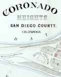 | Details | Anonymous | 1891 |
| Antique lot plan of Coronado Heights in San Diego County |
|
Anonymous |
|
| 1891 |
| LOC:88 |
| $210.00 | Anonymous | Antique-lot-plan-of-Coronado-Heights-in-San-Diego-County | Plat map of Coronado Heights Subdivision in San Diego County, California produced a year after Coronado residents voted to incorporate. Shows the grounds for the Hotel de Coronado, completed in 1888, at that time the largest resort hotel in the world.
<br></br>
Includes a boulevard to Coronado Beach as well as the tracks for the Coronado Railway, a street railway system to carry a 50-seat excursion car and steam locomotive. With notes indicating the size of blocks and street width. |
| 135 |  | Details | Anonymous | 1902 |
| Track Chart Anchor Line American Mail Steamships |
|
Anonymous |
|
| 1902 |
| LOC:0 |
| $85.00 | Anonymous | Track-Chart--Anchor-Line-American-Mail-Steamships | Antique ship's track chart of Atlantic Ocean produced by the Anchor Line shipping company that was used by a passenger to track his progress on a Transatlantic cruise. Details the daily latitude and longitude on a 2689 mile voyage of the SS Anchonia between New York and Glasgow on Aug 9th - 19th, 1902. Daily position plots indicate a more northerly path than usual. <BR> </BR>
Document on card stock folds into 3 parts. Front cover lists vessels owned by Anchor Line with their tonnage and shows a frontal view of a steamer underway. Expands to 10"x6" |
| 5364 |  | Details | Anonymous | 1909 |
| Pair of manuscript allegorical Maps of the Heart, anatomically correct. |
|
Anonymous |
|
| 1909 |
| LOC:13 |
| $1,100.00 | Anonymous | Pair-of-manuscript-allegorical-Maps-of-the-Heart--anatomically-correct- | Two rare <b>manuscript pen and ink</b> anatomically-correct heart-shaped geographical guides or allegorical maps: "Map of Man's Heart" and "Map of Woman's Heart". Both maps are attributed within circular cartouches reading "Surveyed and Drawn by HUB. Scale 2 miles = 1". 1909." This style of anatomical heart-shaped maps and some of the traits are not found anywhere online.
<br></br>
After similar Victorian-era maps by D.W. Kellogg & Co. of Connecticut ca. 1840. Unlike this manuscript pair of maps, the Kellogg lithographs were based on a stylized and exaggerated bi-lobed conception of the heart- the "Valentine" heart that we know today. Despite the differences in wording of traits, the theme of negative stereotypes for women is the same.
<br></br>
Map of Man's Heart includes large areas devoted to patience, modesty, fidelity (twice), benevolence, humanity, knowledge and love. On the other hand, the Map of Woman's Heart largely features conceit, jealousy, scandal, duplicity, deceit, fickleness and avarice among other traits. The woman's heart is pierced by the "River Tongue" and surrounded on one side by the "kleptomaniac ocean" and on the other side, the "cantankerous ocean".
<br></br>
Seller attributes the provenance to India "it came from a nurses friendship book, she being based in Bangalore India - her name was probably MacDonald." |
| 5482 |  | Details | Anonymous | 1910 |
| Copper Belt of Alaska Manuscript Copper Mining |
|
Anonymous |
|
| 1910 |
| LOC:90 |
| $700.00 | Anonymous | Copper-Belt-of-Alaska-Manuscript-Copper-Mining | Intriguing pen and ink manuscript map related to early copper mining in Alaska ca. 1910 in the area of the Wrangell Mountains, east of Anchorage. Shows an area spanning about 100 miles E-W with the Hanagita Trail, Tonsina Station (est. 1903), and the properties of the New York-Alaska Copper Co, Copper River Mining Co., and White River Mining Co. Does not show the lines for the Copper River and Northwestern Railway (est. 1911) and most important the Kennecott Mines or townsite (ca. 1911).The map would have been used to produce multiple blue-printed copies (cyanotypes).
<br></br>
Shows the McClellan trail taken by parties led by R.F. McClellan (Chittyna Exploration Company) in 1898 and 1899 to the Copper River and then on eastward along the Chitina River where large copper lode discoveries were made exploited by the Bonanza Mine and the Nicolai Mine. Some of the parties disputed the ownership of the finds, formed a separate entity (Copper River Mining Company) and brought suit against Chittyna Exploration in 1902. The suit was decided in favor of McClellan and his partners of the Chittyna Exploration Company. In 1903 Stephen Birch consolidated 21 claims as "Alaska Copper and Coal Company", enlisted the help of J.P. Morgan and Daniel Guggenheim, and founded the Kennecott Copper Company.
<br></br>
Includes key features: Bonanza Mine, Nickolai Mine, Skolai Pass, Wrangell Glacier, Long Glacier, and Mount Wrangell.
<br></br>
Manuscript trace map on surveyor's tracing cloth (paper). N |
| 5249 | 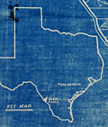 | Details | Anonymous | 1910 |
| Cyanotype blueprint map Shaw Ranch Webb County Texas |
|
Anonymous |
|
| 1910 |
| LOC:10 |
| $0.00 | Anonymous | Cyanotype-blueprint-map--Shaw-Ranch-Webb-County-Texas | SOLD
<br></br>
Rare cyanotype or blueprint map of the Shaw Ranch along the Rio Grande River in Webb County, Texas. Date est ca. 1910 (possibly 19th C.). Includes the Huajolote (Guajolote) Ranch and pasture of 24,481 acres (near center), the Antonio Guerra tract of 13,000 acres and the Loza pasture of 15,942 acres.
<br></br>
At lower right a context or key map shows the location of the Shaw Ranch with respect to Texas' boundaries and to the town of San Antonio.
<br></br>
The Shaw ranch was originally the property of Felix Motlow Shaw (1859 - 1908) a trail driver, rancher, and cattleman. Shaw was known as one of two cattlemen who introduced shorthorn bulls to the Carizzo Springs area. After Felix Shaw's death in 1908, Shaw's wife, Florence Terry Shaw, took over and successfully managed the ranch, expanding her holdings to over 100,000 acres.
<br></br>
Remarried, Florence Terry Griswold (1875 – July 7, 1941) was the first woman delegate of the Texas Cattle Raisers Association and for several years the only female delegate. She was a staunch supporter of women's equality, worked as a suffragist for many years and later fought for equal pay for women. Florence T. Griswold is best known as the founder of the Pan-American Round Tables in 1916. |
| 5102 |  | Details | Anonymous | 1910 |
| Key West, Florida Bird's-eye View from Lighthouse Showing the Harbor. |
|
Anonymous |
|
| 1910 |
| LOC:0 |
| $0.00 | Anonymous | Key-West--Florida-Bird-s-eye-View-from-Lighthouse-Showing-the-Harbor- | SOLD
<br></br>
Scarce, framed color panoramic photograph ca. 1910 "Key West, Florida Bird's-eye View from Lighthouse, Showing the Harbor." Shows Key West homes before they were electrified. A horse and buggy are shown driving down Whitehead Street. Not examined out of frame but believed to be a scarce, 3-panel folding postal card, never folded.
<br></br>
In period bubble-glass and wood frame with original black backing and seller's label for Babberger Studio, Canon City, Colorado. Babberger's photography studio in Colorado burned on December 14, 1915, destroying all the contents [1]. William Babberger was a noted bee keeper whose apiary was featured in the January 1913 edition of the American Bee Journal.
<br></br>
Not found for sale online.
<br></br>
[1] Source: Online. Bulletin of Photography, Volume 17. p. 793. |
| 5190 |  | Details | Anonymous | 1912 |
| Saloon Map of New Haven Connecticut |
|
Anonymous |
|
| 1912 |
| LOC:200 |
| $400.00 | Anonymous | Saloon-Map-of-New-Haven-Connecticut | Very scarce thematic map related to the temperance movement: "Saloon Map of New Haven, Connecticut" where red dots indicate the location of saloons within the city. Left side with statistics unfavorable to the consumption of alcohol which link alcohol to many of the ills besetting New Haven at the beginning of the twentieth century. For example:
<div class="indenttextblocksingle">
<ul style="list-style-type: circle;">
<li>One saloon to every 349 inhabitants.</li>
<li>42 percent of New Haven's arrests are for drunkenness.</li>
<li>44 percent of New Haven inmates of jail are there for drunkenness</li>
<li>60 percent of New Haven children in local public institutions in 1911 due to drunkenness of parents.</li>
</ul>
</div>
[ alcohol, temperance, prohibition, bar, pub, drinking, intoxication ] |
| 4904 |  | Details | Anonymous | 1912 |
| Plan General de St. Laurent de Maroni French Guyana Papillon |
|
Anonymous |
|
| 1912 |
| LOC:88 |
| $600.00 | Anonymous | Plan-General-de-St--Laurent-de-Maroni-French-Guyana-Papillon | Unrecorded plan for the <b>French Penal Colony at St. Laurent</b> along the Maroni River in French Guyana. Established by Napoleon III in 1850, for almost 100 years St. Laurent de Maroni was the main penal establishment of French Guiana. Rare.
<br></br>
Henri Charriere, the famous prisoner <b>Papillon</b> of the eponymously named film starring Steve McQueen and Dustin Hoffman, was a prisoner at St. Laurent de Maroni. The prison can be found on the map at top center surrounded by a wall . The prison complex included a old hospital and a new hospital, a transportation camp, the "Quartier Disciplinaire. The hospital was among the inmates favorites. Many prisoners faked illnesses just to be sent to the hospital so that they could plan their escape more easily.
<br></br>
The town of Saint-Laurent-du-Maroni proper was founded on 16 March 1880. St. Laurent was a penal town whose inhabitants were nearly all guards or liberated prisoners. The hospital was built in 1912, and the prison itself closed in 1946, the same year the whole colonial penal system was abolished. |
| 5315 | 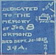 | Details | Anonymous | 1918 |
| Plat map Halifax Company Lands Ormond Volusia Florida |
|
Anonymous |
|
| 1918 |
| LOC:53 |
| $0.00 | Anonymous | Plat-map-Halifax-Company-Lands-Ormond-Volusia-Florida | SOLD<br><br>A plat map for Halifax Company Lands in Volusia County, Florida. This plat reflects the desire to subdivide the land into smaller lots for residential and commercial use . Shows manuscript crayon notations (in red) "Bunnell 9 mi." and "Rt. 1", for Ridgewood Avenue a stretch of the Dixie Highway, as it turned west to Bunnell, Florida through what is today the Halifax Plantation area.
<br></br>
Rare early cyanotype (blueprint) plat of the subdivision of Halifax in Volusia County, Florida (near Bulow Creek State Park and northwest of Ormond Beach), bounded to the west by the <b>Old King's Road</b>. An updated plat of the area <b>previously platted as the Harwood Subdivision in 1888 by Norman Harwood</b> (see our stock number 5314). In comparison to P. D. Roger's 1888 plat of the same area, this map shows no indication of land use (hammocks, islands, marsh) suggesting that the land was drier by this date.
<br></br>
The plat shows the tomb of James Ormond II who died September 30, 1829 (now Ormond Tomb State Park).
<br></br>
Some of the differences between this plat and the earlier plat of Harwood (1888) include:<br></br>
<div class="indenttextblocksingle">
<ul style="list-style-type: circle;">
<li>Most of the streets are re-named. What is today "the Old Dixie Highway" was named Ridgewood Avenue. The Dixie Highway was constructed between 1915 and 1929.</li>
<li>Bead, Knox & Bead canal is shown entering Bulow Creek.</li>
<li>Many new building sites are platted north of Ormond Tomb on both sides of Ridgewood Avenue.</li>
<li>Plat clearly shows the north and south boundaries of the Ormond Grant.</li>
<li>This plat shows in more detail and names the extent of the Mary Kunner grant.</li>
<li>Harwood Grove Company plot is now labeled Halifax Grove Reservation, reflecting a change in ownership.</li>
</ul>
</div> |
| 5053 |  | Details | Anonymous | 1918 |
| Two manuscript maps of St. Augustine, Florida and of the area. |
|
Anonymous |
|
| 1918 |
| LOC:11 |
| $400.00 | Anonymous | Two-manuscript-maps-of-St--Augustine--Florida-and-of-the-area- | Two manuscript maps on a single sheet inserted into a tourism brochure of St. Augustine, Florida after printing. Unusual. Maps show St. Augustine at street-level detail and on verso a smaller-scale map of the area surrounding St. Augustine. Type-written text on one map sheet indicates re-use of a telephone service remittance document for creation of the map. The small scale map of the area around St. Augustine appears only to consider railway lines (F.E.C., A.C.C.) of importance as railways are highlighted in color and stops along each route are identified.
<br></br>
Booklet (folds to 4" x 9") presented with the compliments of the St. Augustine Hotel Association. Fine cover graphics of period clothing. Booklet art work, engraving and printing by the Record Company, St. Augustine. Dated between 1916 and 1919 based on information provided about the Flagler Hospital, under construction at printing, after a fire in 1916 destroyed much of the original structure. |
| 6586 |  | Details | Anonymous | 1924 |
| Map of City of Palo Alto Santa Clara County California |
|
Anonymous |
|
| 1924 |
| LOC:59 |
| $150.00 | Anonymous | Map-of-City-of-Palo-Alto-Santa-Clara-County-California | Map of Palo Alto, California in Santa Clara County dated within to November, 1924. At map bottom, below Alma Street, is Stanford Park, the Palo Alto Stock Farm, Palo Alto Union High School, and Stanford University and stadium.
<br><br>
The map of Palo Alto shows tract numbers, and the location of numerous tracts, subdivisions and developments including Clara Vista, Alba Park Addition, the Alcorn tract, and Ravenswood.
<br><br>
Palo Alto city limits in 1924 are shown with a dotted line. |
| 4900 |  | Details | Anonymous | 1925 |
| Cyanotype Heath Robinson contraption goat-powered torpedo |
|
Anonymous |
|
| 1925 |
| LOC:62 |
| $650.00 | Anonymous | Cyanotype-Heath-Robinson-contraption-goat-powered-torpedo | You will likely never see another one of these. From the Roaring Twenties- a cyanotype (blueprint) Heath Robinson style contraption- a goat-powered torpedo. The satirical proposed device shows advanced knowledge of torpedo design and function. (e.g. bulkheads).
<br></br>
Early Newport, RI colonists used Goat Island as a goat pasture. In 1925 the U.S. Navy operated a torpedo manufacturing, development and testing station on Goat Island.
<br>
<div class="indenttextblock">The anonymous author explained:
"The torpedo is made in three sections, the head, the midship section and after body. The drawing shows the mechanism at rest. The operation is as follows: When the torpedo is fired from the tube the trigger comes in contact with a lug which causes the trigger arm to displace the cobble with falls on the Bermuda onion and crushes it. The onion gases thus released cause the goat to weep copiously. The tears are caught in the funnel on the top of the sal-ammoniac pin. These tears dissolve the sal-ammoniac pin. Thereby releasing the spring rod and prodder. This unit moves smartly forward, engaging the port quarter of the goat, thereupon the goat steps out and operates the asbestos tread mill, which is connected to the gear train that operates the propellers. A gaff and boom rig operated by the gear train, operates a spur gear which revolves rapidly on the goats back guaranteeing the continuance of the motion started by the goat prodder, the derby on the goat prevents him from catching cold while the torpedo is in the tube. It is obvious that if he should catch cold he would be rendered useless as an onion weeper. The hat also serves as a cut-off in the following manner; after a certain speed has been attained the goat has a desire to take off his hat and be comfortable, so he therefore tosses it to the rear where it falls in the gear train and jams it. Any torpedo expert will explain this to you if the above elucidation is not perfectly clear.
</div> |
| 6860 | 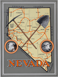 | Details | Anonymous | 1926 |
| Unrecorded Pictorial Map of Nevada and Calendar |
|
Anonymous |
|
| 1926 |
| LOC:89 |
| $350.00 | Anonymous | Unrecorded-Pictorial-Map-of-Nevada-and-Calendar | A very fine pictorial advertising map of Nevada from the Virginia City Bank of Virginia City, Nevada. With a complete calendar for 1926 at bottom. Includes unused metal hanger at top. A rare survivor in excellent condition. Map size 9.5" x 12.5". Overall, about 12" x 23".
<br><br>
<div id="0" align="center">
<a title=""></a>
<img id="6860" src="/ZoomifyImages/SC_6860/SC_6860_detail1.jpg" alt="Unrecorded Pictorial Map of Nevada with Calendar from 1926" width="240"/> <br><br> <font size="-2">1926 Virginia City Bank Advertising Map</font>
</div><br>
Virginia City, Nevada, was a historic mining town that experienced a significant boom in the mid-19th century due to the discovery of the Comstock Lode, a large deposit of silver ore. By 1926, however, the city had long passed its heyday and was in a state of decline. In 1926, the population was estimated to be around 1,500 people, a far cry from the 25,000 residents during the height of the mining boom.
<br><br>
In the early 20th century Virginia City began to shift its focus towards tourism. Efforts were made to embrace, preserve and promote the town's rich mining history and Wild West character to attract visitors. This map reflects that sentiment. |
| 4820 |  | Details | Anonymous | 1926 |
| Rare Plan of the Carissa Gold Mine, South Pass, Wyoming |
|
Anonymous |
|
| 1926 |
| LOC:200 |
| $400.00 | Anonymous | Rare-Plan-of-the-Carissa-Gold-Mine--South-Pass--Wyoming | Rare cyanotype (blueprint) gold mine plan and section of the <b>Carissa Mine</b>, South Pass City, Wyoming.
<br></br>
During the late 1860s, miners discovered gold near South Pass City and the Carissa mine quickly became the most productive of all mines in the Sweetwater Mining District. After nearly 100 years, the Carissa Mine finally ended operations permanently in 1954.
<br></br>
Dated with reference to a similar, more detailed map of 1926 made during a detailed assay of the entire mine. (Hausel, W. Dan .The Carissa Gold Mine, South Pass Wyoming-A Sleeper. ICMJ. Prospecting and Mining Journal. July, 1999)
<br></br>
Three drawings are included: Longitudinal Section; Plan of the Third Fourth and Fifth Levels; and Claims Comprised in the Carissa Group.
</div>
Claims included the "Lucky Strike Placer", "Hermit Placer", "Chas. Dickens" and "Jeanette 183."
<br></br>
<a href="https://www.southpasscity.com/carissa-tours" target="_blank">South Pass City</a>
today is operated as a Wyoming state historic site with 40 historic buildings, one of the best-preserved gold mining towns in the American West:
<div class="indenttextblock">
"The State of Wyoming bought the 200-acre Carissa Mine site and began a ten-year restoration and reconstruction project. The interior was restored to the post–World War II period, when the mine and mill were most productive and milled approximately sixty tons of ore per day in three round-the-clock shifts. The reinstalled equipment is now fully functional. The State of Wyoming runs the Carissa Mine as part of the South Pass City State Historic Site, with tours of the mill that include demonstrations of the mid-twentieth-century milling equipment in operation."
<b>Samantha Ford, “Carissa Mine” [Lander, Wyoming], SAH Archipedia, eds. Gabrielle Esperdy and Karen Kingsley, Charlottesville: UVaP, 2012—, http://sah-archipedia.org/buildings/WY-01-013-0097.</b>
</div> |
| 5427 |  | Details | Anonymous | 1929 |
| Map of the University Pool oilfield in Pecos County, Texas |
|
Anonymous |
|
| 1929 |
| LOC:300 |
| $0.00 | Anonymous | Map-of-the-University-Pool-oilfield-in-Pecos-County--Texas | SOLD<br><br>Large anonymous oilfield cadastral map of the University Pool oilfield in Pecos County, Texas ca. 1929. An unintentional found work of abstract art- a 38" x 30" blueline map with hand color of leased tracts by pencil with similar ownership designated by coloring.
<br></br>
Across the center of entire map are simply the words: <strong>"State University Land."</strong>
<br></br>
Numerous lessees are noted on the map with many large and small oil companies including:
<div class="indenttextblocksingle">
<ul style="list-style-type: circle;">
<li>Tower & McKanna</li>
<li>Dixie</li>
<li>Shell</li>
<li>Humble</li>
<li>Tidal</li>
<li>Transcontinental</li>
<li>Tay-Link</li>
<li>California</li>
<li>W.R. Jones</li>
</ul>
</div>Large manuscript crayon filing notation on the verso reads "Rowan-Tong Area, Pecos County." |
| 5393 |  | Details | Anonymous | 1930 |
| Fragments of a manuscript illustrated map of the Caucasus early oil industry |
|
Anonymous |
|
| 1930 |
| LOC:2 |
| $190.00 | Anonymous | Fragments-of-a-manuscript-illustrated-map-of-the-Caucasus-early-oil-industry | Fragments of a larger manuscript pictorial map ca. 1930 of the Soviet Caucasus with early oil industry views. The fragments feature inhabitants of the republics in traditional outfits, some views of the oil derricks and traditional "bazaar" (marketplaces). Illustration of oil derricks show them enclosed in a fabric-covered frame to protect the drilling equipment against the very harsh cold.
<br></br>
The first fragment features Tajik, Turkmen & Uzbek ASSR. The second fragment features Dagestan ASSR, Kabardino-Balkar ASSR, Transcaucasian SFSR and other autonomous republics.
<br></br>
Attributed to a GIZ / IZOGIZ State design bureau worker. Izogiz was the fine arts section of Ogiz publishing. Ink, pencil, gouache on paper. |
| 5058 |  | Details | Anonymous | 1930 |
| Lane Park Cottages Lake Harris Tavares, Florida |
|
Anonymous |
|
| 1930 |
| LOC:11 |
| $50.00 | Anonymous | Lane-Park-Cottages-Lake-Harris-Tavares--Florida | Small map of Lane Park Cottages on Lake Harris, three miles southwest of downtown Tavares, Florida ca. 1930's. Lane Park is named for Captain A.J. Lane who as early as 1883 had plans for developing a peninsula that extended into Lake Harris. Map is on a postcard with two photographs of the cottages.
<br></br>
These cottages were likely the same as those attributed to Robert Kleiser:
<div class="indenttextblock">
"Kleiser's Fish Camp was established in 1918 on an island located in the middle of Lake Harris. Robert Forest Kleiser acquired the island and built six cottages, several boat sheds, and a pier. Several years later, Kleiser disassembled the cottages and moved the camp to Lane Park." (Grenier, Bob. Images of America: Tavares. Arcadia Publishing. 2011)
</div>
</br>
Printed by the County Seat Printers, Tavares, Florida. |
| 6728 |  | Details | Anonymous | 1932 |
| Child's pencil box pictorial map United States |
|
Anonymous |
|
| 1932 |
| LOC:13 |
| $125.00 | Anonymous | Child-s-pencil-box-pictorial-map-United-States | Lithographed uncommon pictorial map ca. 1932 of the United States by the Joseph Dixon Crucible Company (DCC). Inset maps for the Philippine Islands, Alaska, Hawaiian Islands, Panama, and Porto Rico. Map interior is the standard cotton, cattle, and cactus and the seas are filled with the scene of a whaleboat capsized by its quarry, a fierce WWI-era battleship, a passenger liner, and a single-deck ship-of-the-line, possibly the Constitution. Following restoration that began in 1925, the Constitution sailed on a 90-port tour along United States' coasts by late 1931.
<br><br>
The DCC is also credited with the publication of Dixon's Mickey Mouse Map of the United States ca. 1936. That 10"x14" map was designed for inclusion in a set of child's pencils.
<br><br>
The Dixon Crucible Company was established by Joseph Dixon in Jersey City, NJ in 1847. Dixon (1799-1869) invented the Dixon Ticonderoga pencil, which was made by mixing graphite with clay and water and pressing it into grooved cedarwood. The company was taken over by Dixon's son-in-law, Orestes Cleveland, who established it as a highly regarded brand for mass production. The company suffered financial setbacks due to Cleveland's malfeasance, but it was saved by Edward F.C. Young and eventually came under the control of his son-in-law George T. Smith. The manufacturing complex was later converted into the Dixon Mills, a mixed-use apartment complex. In 2005, Dixon-Ticonderoga was acquired by the Italian-based FILA Group, a manufacturer in Mexico and China. |
| 5266 | 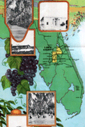 | Details | Anonymous | 1933 |
| Advertisement with map for Lake County, Florida |
|
Anonymous |
|
| 1933 |
| LOC: |
| $175.00 | Anonymous | Advertisement-with-map-for-Lake-County--Florida | Map of Lake County, Florida on an advertising brochure from the Lake County Chamber of Commerce. Fine graphics focused on the agricultural bounty available in a fertile and water-rich Florida. Shows numerous cities in central Florida including Altoona, Eustis, Howey, Clermont, Tavares, Sanford, and Orlando. Inset half-tone black and white illustrations of scenes typical to the area.
<br></br>
Brochure was issued by the Lake County Chamber of Commerce in Tavares, Florida to registrants at the Florida Exhibit during the Century of Progress Exhibition in Chicago (the 1933-34 Chicago World's Fair). |
| 6677 |  | Details | Anonymous | 1936 |
| About and Roundabout Tucson pictorial map Arizona botanical interest |
|
Anonymous |
|
| 1936 |
| LOC:86 |
| $250.00 | Anonymous | About-and-Roundabout-Tucson-pictorial-map-Arizona-botanical-interest | Neat pictorial map of Tucson, Arizona, filled with historical facts and illustrated with simple sketches related to the city's long and colorful history. Bernice Walkley Porter, a Vassar graduate, is credited with creating a map "About and Roundabout Tucson" in 1936 (1). Though untitled, the map here is apparently Porter's and was issued as an folded untitled insert in a guide book by the same name that was published by the Junior League of Tucson in 1936. Verso with a road map of the state of Arionna.
<br><br>
During the 1930s, Bernice Walkley and Rutger Porter operated Desert Gardens Nursery on the same property as their small adobe house in Tucson. Rutger's love for desert plants earned him the nickname "Kactus Kid". Together Bernice and Rutger expanded their home and created the garden surrounding it. Over the years, their garden evolved into a beautiful oasis of winding walks, adobe walls, fountains, and greenery that reflected the sturdier choices for the Tucson climate.
<br><br>
The Porters closed their Desert Gardens Nursery in 1958. However, Bernice had a dream of turning their beloved property into a public garden, and donated it to the City of Tucson in 1968. By the early 1970s, the Tucson Botanical Gardens and the Porter property became a reality, with the City passing a resolution to develop the property into a horticultural center, sanctuary for wild birds, and a center for education. The Porter's adobe house now serves as the Gift Shop for the Tucson Botanical Garden
<br><br>
Many of the original plants from the Porter estate, including citrus, roses, privet, and jasmine, are still preserved in the Historical Garden, which represents the oasis style typical of large Tucson gardens dating from the 1920s to the mid-1960s.
<br><br>
(1) Griffin, Dori. Mapping Wonderlands: Illustrated Cartography of Arizona, 1912–1962. United States, University of Arizona Press, 2013. p. 192. |
| 6727 |  | Details | Anonymous | 1937 |
| The Meridian Highway Main Street of North America |
|
Anonymous |
|
| 1937 |
| LOC:13 |
| $0.00 | Anonymous | The-Meridian-Highway-Main-Street-of-North-America | SOLD<br><br>Attractive, scarce, lithographed 1937 map of U.S. Highway 81 "The Meridian Highway, the Main Street of North America", Hadley Sumner, Selling Agent. Apparently a promotional insert as the bottom states: "For complete information inquire Chamber of Commerce at address on other side." Insert illustrations of the International Bridge at Laredo, Texas, the Meridian Bridge on the Missouri River as well as commercial exports: wheat, corn, cattle. and a lake.
<br><br>
The Meridian Highway was established in 1911-12 as a major north-south route through the Great Plains from Canada to Mexico, following the land division grid parallel to the sixth principal meridian. Originally known as the Meridian Road, it primarily served as a farm-to-market road, passing through each county seat along the way. The Meridian Highway Association was formed in 1911 to promote and map the highway, consisting of representatives from the states, counties, and cities along the route. The completion of the Meridian Highway Bridge in 1924 at the Missouri River between Yankton, South Dakota, and Nebraska marked a significant evolution of the route into a modern highway. Today, the Meridian Highway is the foundation of one of the busiest and most significant transportation corridors in the nation, crossing over 800 miles of Texas and passing through major cities such as Wichita Falls, Fort Worth, Waco, Austin, San Antonio, and Laredo.
<br><br>
Verso is blank. Executed by Epsten Litho. Co. Omaha. |
| 6487 |  | Details | Anonymous | 1938 |
| Roadside attraction flyer for mythical Hidden City South Dakota |
|
Anonymous |
|
| 1938 |
| LOC:78 |
| $135.00 | Anonymous | Roadside-attraction-flyer-for-mythical-Hidden-City-South-Dakota | Very scarce advertising flyer ca. 1938 with map for the long-forgotten <strong>Hidden City</strong>, a roadside attraction in South Dakota's Black Hills; Admission 25 cents.
<br><br>
<div id="ll" align="center">
<a title="Hidden City, SD"></a>
<img id="ii" src="/ZoomifyImages/SC_6487/SC_6487_DinoSign.jpg" alt="1940s sign for Hidden City Roadside Attraction" width="260"/> <br><small>1940s road sign for Hidden City <br>(not included)</small>
</div><br>
The recto teases "Did Alley Oop ? ? ? ? ? ." "Prehistoric Walls, Cross Walls, Arches and Pavements with Hieroglyphics. Lost City?" and includes a crude drawing of 1930s artist's concept of a caveman, complete with loincloth and club.
<br><br>
</ul>
</div>
<div id="1z" align="center">
<a title="Hidden City, SD"></a>
<img id="3" src="/ZoomifyImages/SC_6487/SC_6487_Detail.jpg" alt="" width="300"/> <br><small>Hidden City, South Dakota Roadside Attraction</small>
</div><br>
Verso with a road map of South Dakota highlighting the location of a number of area attractions, both large and small. The less well-known of these attractions include:
<div class="indenttextblocksingle">
<ul style="list-style-type: circle;"></li>
<li>Black Hills Rock Museum</li>
<li>Black Hills Sugar Factory, Belle Fourche</li>
<li>Stage Barn Caverns</li>
<li>Water Carnival and Race Meet</li>
<li>Nameless Cave</li>
<li>Strato Bowl</li>
</ul>
</div>
Earl Brockelsby, who later started another attraction in 1937, Reptile Gardens, worked as a tour guide at Hidden City. |
| 5430 |  | Details | Anonymous | 1938 |
| Detailed map Railroads Interchanges, and Terminals New Orleans Louisiana |
|
Anonymous |
|
| 1938 |
| LOC:1401 |
| $900.00 | Anonymous | Detailed-map-Railroads-Interchanges--and-Terminals-New-Orleans-Louisiana | Original unrecorded blueprint (cyanotype) map of the railroad network in New Orleans in 1938. At a high level, the map shows the ownership and location of railroad tracks, interconnections (Interchanges) between railroad lines, and input/output points to the rail system (Terminals). Includes parts of the West Bank communities of Avondale, Westwego, Marrero, Harvey, Gretna, and Algiers. Also clearly shows the Industrial Canal (opened 1923) [1] and the New Orleans Lakefront Airport, then the Shushan Airport (opened 1934).
<br></br>
Shows the West End (remember Brunings? Fitzgerald's?) and the <strong> New Basin Canal</strong>, now long filled.
<br></br>
For many years New Orleans was a key seaport. Its location allowed access to large ships (cutting edge technology at that time) from across the world and provided a water route into the heart of the United States that favored movement of bulk goods and people.
<br></br>
At extreme upper left is a numerical index to key streets and locations in New Orleans (e.g. Julia Street, N.O. Cooperative Butchers Abattoir, and the Cotton Warehouse and Elevator). Below that is an index to the location of railroad interchanges and to support locations for railroad logistics operations: Engine Houses, Train Yards, Freight Depots, and Passenger Depots.
<br></br>
[1] More correctly known as the Inner Harbor Navigation Canal (IHNC). The IHNC connects the Mississippi River with Lake Ponchartrain. |
| 5325 |  | Details | Anonymous | 1938 |
| Rare plat map of Sunset Islands, Miami, Dade Florida |
|
Anonymous |
|
| 1938 |
| LOC:61 |
| $0.00 | Anonymous | Rare-plat-map-of-Sunset-Islands--Miami--Dade-Florida | SOLD<br><br>Rare original blueline plan and plat map of the four Sunset Islands in Miami, Dade County, Florida. Contains a inset location sketch, or context map of the islands, at a scale of 1" - 2640 feet. This plat map would have been used in the post-Depression era when sales on the Sunset Islands were rebounding. Date included for each lot to be sold included lot dimensions and price.
<br></br>
Note this an original 1938 one-of-a-kind blueline plat. It is not a modern reprint, copy, facsimile or giclee. Guaranteed.
<br></br>
Sunset Islands (I,II,III,IV) are four man-made islands located in Biscayne Bay and are home to some of Miami's richest and best known residents.
<br></br>
The Sunset Islands were developed by the Sunset Islands Company, headed by Steven. A. Lynch (1882-1969), President of Paramount Pictures. The islands were first platted in 1925. The Sunset Canals were dredged in 1926. Just as the Great Depression struck, Lynch finished filling the islands.
<br></br>
Despite Lynch's early start during the Florida 1920's land boom, construction of new homes on The Sunset Islands did not start in earnest until a decade later, in part because of delaying tactics employed by rival Miami developer Carl Fisher and also due to the slowdown in development during the land-boom crash of the Great Depression. Lynch built a residence on the southwest corner of Sunset Island II named "Sunshine Cottage."
<br></br>
The Sunset Islands were among the last man-made islands created in Biscayne Bay. This plat of the Sunset Islands from 1938 shows only about 25% of the lots with homes on them and almost 50% of the lots left unsold at that time Prices ranged from as low as $2,000 for small interior lots to $29,000 or even $30,000 for a .85 acre lot with 183 feet of waterfront on Sunset Island II. |
| 4914 |  | Details | Anonymous | 1939 |
| Large fold-out tourist handbill with map Saint Augustine, Florida |
|
Anonymous |
|
| 1939 |
| LOC:0 |
| $0.00 | Anonymous | Large-fold-out-tourist-handbill-with-map-Saint-Augustine--Florida | SOLD<br></br>
Scarce tourists' handbill with a map from St. Augustine Florida, ca. 1938. On very thin paper almost certainly designed to be discarded, hence a rare survivor.
<br /><br />
Recto filled with information about points of interest on the map including the:
<div class="indenttextblocksingle">
<ul style="list-style-type: circle;">
<li>Fort Marion National Monument</li>
<li>Indian Burial Ground</li>
<li>Llambias House</li>
<li>Slave Market</li>
<li>Plaza de la Constitution</li>
<li>St. Augustine Ostrich-Alligator Farm</li>
<li>Marine Studios</li>
</ul>
</div>
Verso with facts and statistics about St. Augustine, and St. John's County, Florida. |
| 6499 |  | Details | Anonymous | 1939 |
| Fine colorful map of Bermuda ca. 1939. |
|
Anonymous |
|
| 1939 |
| LOC:90 |
| $125.00 | Anonymous | Fine-colorful-map-of-Bermuda-ca--1939- | An original and very attractive 7"x21" pictorial map of the Bermuda Islands on the recto of a folding promotional brochure for Bermuda in four panels. Numerous simple realistic sketches depict locations that include:
<div class="indenttextblocksingle">
<ul style="list-style-type: circle;">
<li>Ireland Island</li>
<li>Gibbs Hill Lighthouse</li>
<li>St. Paul's Church</li>
<li>Military Barrack Prospect</li>
<li>Harrington Sound</li>
<li>Tucker's Town</li>
<li>Shelly Bay Race Track</li>
<li>St. George</li>
<li>St. Catherines Point</li>
</ul>
</div>Inset street plans for St. George and for Hamilton. North oriented at upper right with a fine colorful compass rose. Text below the map includes latitude and longitude coordinates for Bermuda and a scale of miles.
<br><br>
The verso contains photos and text related to steamship service to Bermuda from several maritime firms including:
<ul style="list-style-type: circle;">
<div class="indenttextblocksingle">
<ul style="list-style-type: circle;"></li>
<li>The Furness Bermuda Line</li>
<li>The Pacific Steam Navigation Company</li>
<li>The Munson Steamship Lines</li>
<li>The Canadian National Steamships</li>
<li>Elders & Fyffes, Ltd.</li>
<li>New York Bermuda Lines</li>
</ul>
</div> |
| 5250 |  | Details | Anonymous | 1940 |
| Cyanotype map of Annapolis, Maryland and Naval Academy |
|
Anonymous |
|
| 1940 |
| LOC:10 |
| $0.00 | Anonymous | Cyanotype-map-of-Annapolis--Maryland-and-Naval-Academy | SOLD
<br></br>
Rare anonymous blueprint or cyanotype map of Annapolis, Maryland. Coverage includes the Severn River, Spar Creek, College Creek and the grounds of the United States Naval Academy. Includes an area of "proposed extension of Academy grounds." Dated within to 1940.
<br></br>
Scale 1" = 2000 feet. Drawn by E.W.H. |
| 6868 |  | Details | Anonymous | 1940 |
| Pictorial Map Metropolitan Oakland California Pre-war |
|
Anonymous |
|
| 1940 |
| LOC:89 |
| $300.00 | Anonymous | Pictorial-Map-Metropolitan-Oakland-California-Pre-war | Scarce unattributed pictorial map of the metropolitan Oakland, California. Likely dates to circa 1940 based on the aircraft style in one of the photographic vignettes and the fact that the Oakland Bay Bridge, built 1936, appears on the map. Unsigned and undated. |
| 5269 |  | Details | Anonymous | 1942 |
| German propaganda poster of Japanese capture of Singapore WWII |
|
Anonymous |
|
| 1942 |
| LOC:59 |
| $0.00 | Anonymous | German-propaganda-poster-of-Japanese-capture-of-Singapore-WWII | SOLD<br><br>Folding German propaganda poster from WWII related to the fall of Singapore, once thought to be the "Gibraltar of the East", to the Japanese in February 1942. This broadside propaganda poster was produced by the German Army's Department of Wehrmacht Propaganda to mock the British for their failure to protect Singapore from Japanese attack.
<br></br>
In "Singapura em poder dos japoneses" four views show Japanese soldiers stalking through the jungle and marching in formation with tanks, and Japanese warplanes strafing the airport. Inset map at center shows the supply lines from the Allies to Singapore interrupted or cut (shows scissors) and numerous British and American bases captured throughout the South China Sea , the Philippines, and Malaya.
<br></br>
At bottom: "A castello forte britanico na Grande Asia foi desbarratado Churchill e Roosevelt tambem ali perderam a jogo" reflecting the magnitude and impact of the defeat.
<br></br>
Verso with text related to Singapore and details of the conflict in Asia. Portuguese text.
<br></br>
[Singapora, Singapura, Singapour] |
| 4922 |  | Details | Anonymous | 1942 |
| Poster of Singapore captured and occupied by the Japanese |
|
Anonymous |
|
| 1942 |
| LOC:59 |
| $0.00 | Anonymous | Poster-of-Singapore-captured-and-occupied-by-the-Japanese | This item is sold, but see <a href="https://www.rarecharts.com/ShowDetail/Creator/Anonymous/Title/German-propaganda-poster-of-Japanese-capture-of-Singapore-WWII/5269" target="_top"> another copy in our inventory </a> with an updated description.
<br /><br />
Folding German propaganda poster from WWII related to the fall of Singapore to the Japanese in February 1942. |
| 4845 |  | Details | Anonymous | 1945 |
| WWII MS Cartoon Map of Vita Levu, Fiji Islands |
|
Anonymous |
|
| 1945 |
| LOC:200 |
| $0.00 | Anonymous | WWII-MS-Cartoon-Map-of-Vita-Levu--Fiji-Islands | SOLD<br><br>
Artistically produced manuscript G.I. pictorial map from World War 2 era of Fiji's largest island, Vita Levu. Full of small cartoonish drawings of island life, especially as related to the military with Div. HQ. Suva noted near Suva Bay and Natambua OCS (Officer Candidate School).
<br></br>
Some of the cartoons could suggest a feature in a specific geographic area on Vita Levu but other drawings seem to commemorate group events like a fishing expedition to the nearby Yasawa islands. Viewed as a graphical record of a trip to OCS, the map would document the group's arrival by cargo ship, their overland trip to the OCS by car and then train, passing an airbase; then their arrival and recreation at OCS including swimming and fishing. At mid right a grass-skirted long-haired native offers a G.I. a drink of Fiji's national beverage, Kava.
<br></br>
There was threat of Japanese invasion for the majority of 1942 and part of 1943, which resulted in a build up of military forces and defensive installations. However, World War 2 never reached Vita Levu or any Fijian Island in the South Pacific. In later years, Fiji was used as a forward base for the Allied forces, which resulted in the construction of transportation infrastructure, as well as an influx of Allied troops and supplies coming into the island. Dated as 1945 with the view that fishing expeditions would have been frowned upon in a potential combat theater, thus post-dates WWII. |
| 5324 |  | Details | Anonymous | 1947 |
| Birdseye view of Johnston Island Atoll Pacific Ocean |
|
Anonymous |
|
| 1947 |
| LOC:300 |
| $295.00 | Anonymous | Birdseye-view-of-Johnston-Island-Atoll-Pacific-Ocean | One of a kind humorous birdseye view of the U. S. base at Johnston Island (also Johnston Atoll) in the Pacific Ocean. The author was clearly a member of the U. S. Armed Forces, probably Navy ("X.O.","yeomen", "chief"), who created this view as a memento or souvenir for others. Focus is one the off-hour entertainment and leisure activities on the island: Johnston Island Little Theater, Officer's Club, Ear Banger's Bar and Grill, J.I. Distillery, fishing, hobby shop, etc.
<br></br>
The date of this item is unclear but probably from the years immediately after WWII. Shows the troops engaged in construction activities. Quonset huts, four-engine propeller driven aircraft, and an airstrip apparently not paved and requiring watering to reduce the dust. No trace of heavy armament, or mention of the enemy, which would surely have been a major concern in the middle of the Pacific Ocean. The Navy operated Johnston Island from 1934 to 1948 when the Air Force took over. The site was used for high-altitude nuclear tests in the 1950s and 1960s.
<br></br>
Reproduced with a diazo process. |
| 5290 |  | Details | Anonymous | 1949 |
| Unrecorded comical map related to the Communist Revolution in China |
|
Anonymous |
|
| 1949 |
| LOC:9 |
| $0.00 | Anonymous | Unrecorded-comical-map-related-to-the-Communist-Revolution-in-China | SOLD
<br></br>
Unrecorded, and somewhat puzzling comical map of East Asia (China, Korea, Japan) inspired by Al Capp's "Lower Slobbovia" cartoon map from Capp's Li'l Abner comic book series (1949). In crude Russian and Chinese-inflected dialect the map documents (in manuscript red ink) the exodus of American workers from Shanghai, China to the United States during the last two years of the Chinese Civil War. This is a U.S. artifact from the early establishment of the People's Republic of China after WWII with a probable connection to the U.S. military [1]. Very rare. Not found anywhere else on this planet.
<br></br>
After the end of WWII United States companies built lucrative businesses within China. During 1948 and 1949, it became clear that the Chinese Nationalist forces under Chiang Kai-shek (supported by the U.S.A.) would be defeated by Chinese Communist forces, led by Mao Zedong and supported by Russia. U.S. diplomats and civilian business leaders began an exodus [2] from China. By May, 1949 the stream of foreigners leaving China was concentrated in Shanghai, China where most caught ships to the U.S.A [3], [4].
<br></br>
Includes a depiction of the Trans Manchuria Railway with an unknown connection to salt. The railway is shown extending from Saltport (Dalian), past Saltograd, Staffograd, past the Rad (Red) River and ending near Slobbovian Salt Mines.
<br><br>
Note:<br>
Humerican = American<br>
Pitchavich=Peretychika, Russia<br>
Havaveto = Pyongyang, North Korea<br>
<br>
[1]"You is here you lucky dogs" = Zama, Japan, the earliest U.S. Army barracks in Japan and the former site of the Imperial Japanese Army Academy.
[2] "Where Rad (Red) revolution is ending Humerican blue platt specials."
[3] "Is showing route of 'Vanishink Humerican' class of 1948 and 1949."
[4] Shows a sea route in MS red ink connecting Gimpo (Kimpo), Korea; Shanghai, China; and the United States. |
| 6428 |  | Details | Anonymous | 1949 |
| Cartoon map of UC Berkeley engineering underground radiation nuclear laboratory |
|
Anonymous |
|
| 1949 |
| LOC:300 |
| $850.00 | Anonymous | Cartoon-map-of-UC-Berkeley-engineering-underground-radiation-nuclear-laboratory | Original centerspread 1949 cartoon pictorial map, "Underground Campus", the campus of the University of California Berkeley, specifically the engineering underground tunnels and facilities including the Radiation Lab. Scientists at the UC Radiation Laboratory, now the Lawrence Berkeley National Laboratory, discovered berkelium (atomic number 97) in 1949 using a 60-inch cyclotron.
<br></br>
<div id="3" align="center">
<a title="California Engineer smoking weed?"></a>
<img id="3" src="/ZoomifyImages/SC_6428/SC_6428_SmokingWhat.jpg" alt="Early depiction of a Berkeley Engineer with roach clip." width="240"/>
</div><br>
The California Engineer began in 1903 as the California Journal of Technology. It was the first college magazine in the west to specialize in the area of science and technology. In January, 1923, after a hiatus of ten years, the magazine was revived and renamed "California Engineer" by the Student Engineers Council (1).
<br></br>
The comical map is centered around Sather Tower with a cutaway view of the subterranean network below the halls at the University of California at Berkeley. Includes Sather tunnel, Leconte Hall, Gilman Hall, Wheeler Auditorium, The Radiation Laboratory housed the research at UC Berkeley during WWII under the Manhattan Project. Note the IBM punch card machine gag at bottom left.
<br></br>
The comical map is from the January 1949 issue of <b>California Engineer</b>, the annual "Mad Issue". 36 pages. Price when issued 25 cents. Published at the University of California, Berkeley, California by the Associated Students of the University of California. |
| 6567 |  | Details | Anonymous | 1949 |
| Castles Inc. map of Hollywood and Los Angeles |
|
Anonymous |
|
| 1949 |
| LOC:3 |
| $750.00 | Anonymous | Castles-Inc--map-of-Hollywood-and-Los-Angeles | Clean, single-sided pictorial advertising map of Hollywood and the surrounding area circa 1948 published by Castle's Camera Store, 1529 Vine Street, Hollywood 28, California. Scarce. Price when issued 5 cents.
<br></br>
Castle's Camera Store operated from a small storefront across from the streamline-moderne style NBC Radio City office and studios at the corner of Sunset and Vine streets. <br></br>
<div>
<img src="/ZoomifyImages/SC_6567/Castles Camera Shop.jpg" alt="Castle's Camera Store Hollywood Storefront" width="300" align="left" style="margin: 0px 20px"/>
Karl Breneman was brother to radio personality Tom Breneman who operated Tom Breneman's restaurant from a location at 1525 North Vine Street, a few doors from brother Karl's Castle's Camera Shop.
<br></br>
Key landmarks on the map include:
<div class="indenttextblocksingle">
<ul style="list-style-type: circle;">
<li>Don Lee Mutual Broadcasting Studios (1313 North Vine Street opened August 1948)</li>
<li>Beverly Hills</li>
<li>Republic Studios</li>
<li>Grauman's Egyptian Theater</li>
<li>Hollywood Ball Park</li>
<li>a television studio</li>
<li>Earl Carrol's</li>
<li>Santa Monica, Ocean Park, and Venice piers</li>
<li>American Legion Stadium</li>
</ul>
</div> |
| 5268 |  | Details | Anonymous | 1950 |
| Small Mid-20th Century blueprint map Memphis Railroad Terminal |
|
Anonymous |
|
| 1950 |
| LOC:13 |
| $135.00 | Anonymous | Small-Mid-20th-Century-blueprint-map-Memphis-Railroad-Terminal | Small unrecorded cyanotype (blueprint) map of Memphis, Tennessee related to the railway lines, rail yards, and railroad depots in the Memphis area. Would have provided a high-level condensed overview of the railways in the Memphis area.
<br></br>
Key features on the map include:
<div class="indenttextblocksingle">
<ul style="list-style-type: circle;">
<li>Union Station</li>
<li>Central Station</li>
<li>Paine Yard</li>
<li>Frisco Yale Yard</li>
<li>Forrest Yard</li>
<li>North Yard</li>
<li>South Yard</li>
<li>Johnston Yard</li>
<li>Motor Car shop</li>
<li>Mississippi River</li>
<li>President's Island</li>
</ul>
</div>
Dated within at May 1950. MS annotation on verso: "V. W. White." [Tenn. , TN] |
| 6530 |  | Details | Anonymous | 1950 |
| Scarce plan of the city of Acapulco, Mexico |
|
Anonymous |
|
| 1950 |
| LOC:86 |
| $0.00 | Anonymous | Scarce-plan-of-the-city-of-Acapulco--Mexico | SOLD
<br><br>
Very unusual and scarce folding map or plan of Acapulco, Mexico on the Pacific Ocean ca. 1950: "Plano de la Ciudad y Puerto de Acapulco". A street plan of Acapulco in the mid-20th century with images of fish, Spanish galleons, and a twin-engine propellor-driven aircraft. Legend at bottom left identifies, government offices, hotels, schools, churches and local public transportation routes identified with red outline color.
<br><br>
Just below the title is a representation of the shield of the city of Acapulco, symbolizing two hands that break a leafy reed.
<br><br>
Numerous subdivisions (fraccionamientos) are noted in bold black headings including:
<div class="indenttextblocksingle">
<ul style="list-style-type: circle;"></li>
<li>Fraccionamiento Mozimba</li>
<li>Fraccionamiento Vista Allegre</li>
<li>Fraccionamiento Magallanes</li>
<li>Fraccionamiento Deportivo</li>
<li>Fraccionamiento Costa Azul</li>
</ul>
</div> |
| 5433 | 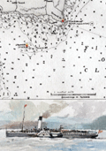 | Details | Anonymous | 1950 |
| Map of Rothesay Sound with watercolor side-wheel steamer. |
|
Anonymous |
|
| 1950 |
| LOC:78 |
| $160.00 | Anonymous | Map-of-Rothesay-Sound-with-watercolor-side-wheel-steamer- | Attractive, offset lithographed chart of Rothesay Sound and the Firth of Clyde, Scotland decorated with a small manuscript watercolor of a side-wheel steamboat. The chart is undated but probably 20th century after an earlier chart. Aids to navigation are highlighted in red and yellow.
<br></br>
The steamboat is unnamed but probably the <strong>Duchess of Fife</strong>, built and launched by Fairfield Shipbuilding and Engineering Company in May 1903. The Duchess of Fife was owned by the Caledonian Steam Packet Company and except for use during WWI and WWII, spent her career serving passenger routes in the Firth of Clyde.
<br></br>
Anonymous but initials "E.S." at bottom right corner. |
| 5066 |  | Details | Anonymous | 1951 |
| Route Map of the Municipal Transit System St. Petersburg, Florida |
|
Anonymous |
|
| 1951 |
| LOC:87 |
| $150.00 | Anonymous | Route-Map-of-the-Municipal-Transit-System-St--Petersburg--Florida | Scarce route map of the Municipal Transit System in St. Petersburg, Florida (not to scale). On thinnish yellow paper a fourteen-panel folding sheet folds to 3" x 8". Includes an inset plan for downtown St. Petersburg revised October, 1951. The Yellow Issue published Dec 3, 1951. |
| 6556 |  | Details | Anonymous | 1952 |
| Pictorial map New Orleans area near Bayou Gardens Lacombe Louisiana |
|
Anonymous |
|
| 1952 |
| LOC:3 |
| $150.00 | Anonymous | Pictorial-map-New-Orleans-area-near-Bayou-Gardens-Lacombe-Louisiana | Pictorial map (1952) of the New Orleans area to promote the Bayou Gardens attraction in Lacombe, Louisiana. The map spans the back two panels of a promotional brochure titled: "Bayou Gardens Lacombe, La. Beauty Spot of the Bayou Country."
<br><br>
Bayou Gardens was a 25-acre gardening attraction located north of New Orleans between Mandeville and Slidell. Bayou Gardens was founded in the late 1940's by convicted felon and former Louisiana Governor Richard W. Leche (1898-1965). In addition to a commercial nursery, swimming pool and a museum, according to the brochure "The Gardens contain one of the nation's outstanding Camelia collections, numbering hundreds of varieties."
<br><br>
Two-panel folding brochure with text on the recto. |
| 4851 |  | Details | Anonymous | 1954 |
| Birds-eye view of the French Riviera |
|
Anonymous |
|
| 1954 |
| LOC:88 |
| $195.00 | Anonymous | Birds-eye-view-of-the-French-Riviera | The recto features a highly detailed birds-eye view and map of the French coast, extending from St. Tropez and St. Raphael to Menton. It highlights various towns, such as <b>Grasse, Cannes, Juan-les-Pins, Antibes, Nice, and Monaco</b>. Additionally, it offers a helpful route map that indicates the names and distances of cities along two travel segments for a journey from St. Raphael to Menton:
<br><br>
<div class="indenttextblocksingle">
<ol>
<li>From Nice to St. Raphael via the Corniche de l'Esterel</li>
<li>From Nice to Menton along the Corniches</li>
</ol>
</div>
<div id="0" align="center">
<a title="French Riviera"></a>
<img id="3" src="/ZoomifyImages/SC_4851/SC_4851_detail.jpg" alt="Old birds-eye view and road map of the French Riviera." width="340"/> <br><small>Nice-Cannes-Menton et les routes du littoral.</small>
</div><br>
Although labeled "Ed 54" on the cover, suggesting a publication date of 1954, the included photographs appear to be from the early 1940s. The map's top section displays the names of mountain peaks in the background, and all text is in French.
<br><br>
On the verso, you'll find extra routes, photographs, and descriptions of various sights and attractions. After reviewing the brochure, it's clear that this area is an excellent candidate for a future vacation destination.
<br><br>
Published by France's Direction générale du Tourisme under the Ministry of Public Works, Transport, and Tourism, this edition is identified as "Ed. 54." |
| 5255 |  | Details | Anonymous | 1958 |
| Pictorial Map of Sanlando Springs attraction near Longwood, Florida |
|
Anonymous |
|
| 1958 |
| LOC: |
| $125.00 | Anonymous | Pictorial-Map-of-Sanlando-Springs-attraction-near-Longwood--Florida | Colorful pictorial map of the Sanlando Springs tourist attraction in Central Florida. Map is surrounded with drawings of family-oriented activities available at Sanlando: Jungle Cruise, outdoor cooking, dancing on the patio. Based on the postal rate of 3 cents this item probably dates to the late 1950's. Folding map, verso with space for a stamp and address as well as a pre-written letter in script touting the many things to do at Sanlando.
<br></br>
Sanlando Springs, along with nearby Rock Springs, Wekiwa Springs and Palm Springs, form the headwaters of the Wekiva River.
<br></br>
The spring, originally Hoosier Springs, was used for recreation as far back as the 1880's. The location was renamed as Sanlando by Altamonte Mayor J.F. Haithcox who developed the location as an amusement park in the 1920's. (Source: https://studiohourglass.blogspot.com/2013/06/giving-new-life-to-sanlando-springs.html). |
| 8064 |  | Details | Anonymous | 1959 |
| Mid century scarf Eglin Air Force Base Florida |
|
Anonymous |
|
| 1959 |
| LOC: |
| $365.00 | Anonymous | Mid-century-scarf-Eglin-Air-Force-Base-Florida | This scarce and colorful mid-20th-century souvenir textile celebrates Eglin Air Force Base, Florida, presenting the installation as a principal proving ground of American air power during the early Cold War. A pictorial map of Florida labeled “Air Proving Ground Command” anchors the design, surrounded by illustrations of jet aircraft, test pilots, target vehicles, and specialized facilities. The textile combines cartographic imagery with promotional aviation art, adapting a souvenir-scarf format widely used for U.S. Air Force bases in the 1950s.<br><br>
The aircraft depicted represent the forefront of U.S. Air Force technology in the supersonic transition era. Shown at mid-left is a B-52 Stratofortress, identifiable by its long straight wings and eight-engine configuration, symbolizing strategic bomber testing. At upper left appears a Lockheed F-104 Starfighter, recognizable by its needle-like fuselage and extremely short wings, while at upper right is a Convair F-102 Delta Dagger, distinguished by its pure delta wing and nose intake. Also depicted is a Republic F-84F Thunderstreak, a swept-wing fighter-bomber widely used in weapons and systems evaluation during the mid-1950s. Additional imagery of test pilots and supersonic tow targets reinforces Eglin’s testing mission.<br><br>
The dating of the textile is supported by both the aircraft selection and the prominent reference to the Climatic Hangar, a facility completed at Eglin in 1954 and widely promoted in subsequent years for extreme-environment testing. The inclusion of the F-102, operational from 1956, and the F-104, which entered U.S. Air Force service in 1958, establishes a firm late-1950s timeframe, while the F-84F reinforces a mid-to-late 1950s context. The absence of later aircraft types or space-age imagery associated with the 1960s further supports an early Cold War date. These elements place the textile most convincingly in the late 1950s, circa 1958 to 1960.<br><br> |
| 5029 |  | Details | Anonymous | 1960 |
| Map and Brochure New Uncle Sam Cruise Tour Biscayne Bay Florida |
|
Anonymous |
|
| 1960 |
| LOC:11 |
| $80.00 | Anonymous | Map-and-Brochure-New-Uncle-Sam-Cruise-Tour-Biscayne-Bay-Florida | Brochure for a 2.5 hour touristic cruise of Biscayne Bay, Miami Beach, Florida aboard the glass-enclosed motorboat Uncle Sam. With a map of the path of the cruise (in red) around Biscayne Bay.
<br></br>
The diesel-powered 84-passenger Uncle Sam departed Pier 10 at the Miami Yacht Basin in Bayfront Park and passed the Venetian Islands, the Flagler Memorial, Fisher's Island then crossed the Rickenbacher Causeway. On the return to the yacht basin the Uncle Sam passed the bayfront estates of James Deering (Villa Viscaya), Charles Coryell, Damon Runyon, and more.
<br></br>
Detailed inset map of access roads and parking for the Uncle Sam cruise. Multi-lingual brochure ca. 1960's with key details translated and targeted to appeal to a Spanish-speaking audience: "Mostrando especialmente las mansiones de Cubanos y Portorriquenos en la zona residential…"
<br></br>
Printed on both sides and folds to 4" x 9". |
| 5056 |  | Details | Anonymous | 1960 |
| Map Seven Seas Sightseeing Miami and Miami Beach Cruise |
|
Anonymous |
|
| 1960 |
| LOC:11 |
| $85.00 | Anonymous | Map-Seven-Seas-Sightseeing-Miami-and-Miami-Beach-Cruise | Brochure for a 2.5 hour lectured cruise of North Biscayne Bay, Miami Beach, Florida aboard the double-decked motorboat Seven Seas. With a map of the cruise route (in red) around North Biscayne Bay.
<br></br>
Unlike other cruises on south Biscayne Bay (e.g. Uncle Sam cruise) the Seven Seas cruise was operated in<b> North Biscayne Bay</b>, departing from Pier 8 at the Miami City Yacht Basin twice daily. The cruise passed the Venetian Causeway, passed the Charles Deering estate, and sailed past the 79th street causeway, retiring past Mt. Sinai Hospital and making a circle in Sunset Lake before docking 2 1/2 hours later. Other points of interest included the Goodyear Blimp Base, Flagler Memorial Monument, Little River, and Indian Creek Village.
<br></br>
Printed on both sides and folds to 4" x 9". |
| 5055 |  | Details | Anonymous | 1962 |
| Lot of six (6) scarce Fin Fishing Charts Lemon Bay to Tarpon Springs Florida |
|
Anonymous |
|
| 1962 |
| LOC:40 |
| $180.00 | Anonymous | Lot-of-six-(6)-scarce-Fin-Fishing-Charts-Lemon-Bay-to-Tarpon-Springs-Florida | Lot of six scarce "Fin Fishing Charts" for Florida coastal areas in the vicinity of Tampa Bay, Florida. Charts folded as issued.
<br></br>
All charts fit inside a point-of-sale envelope/folder printed with an index map of southern Florida showing all available Fin Fishing charts and highlighting these specific charts from Lemon Bay to Tarpon Springs: W7, W8, W9, W10, W11, W12.
<br></br>
Hot fishing spots are highlighted with red dots and tide table adjustments are included for several locations. Several marinas and other business establishments are noted in red on the charts, probably locations that sold these charts or that paid for the advertisement. Ink stamp on the folder carries a date of March 6, 1962. Creator of the charts is unattributed and very few, if any, of these charts are available on the market. |
| 6393 |  | Details | Anonymous | 1967 |
| San Francisco Protest March map, route instructions and monitors armband. |
|
Anonymous |
|
| 1967 |
| LOC:78 |
| $275.00 | Anonymous | San-Francisco-Protest-March-map--route-instructions-and-monitors-armband- | April 15, 1967 San Francisco, California protest march map, monitor instructions, and a crude cloth armband for a march monitor. Rare.
<br><br>
On April 15, 1967 amidst growing opposition to the U.S. war in Vietnam, large-scale anti-war protests were held in New York, San Francisco, and many other cities.
<br><br>
Numerous "monitor's notes" including:
<br><br>
"So far we have had good relations with the police and we would like to keep it that way".
"Above all -keep cool; <b>the armband as a symbol of authority will handle most situations by itself</b>". |
| 5193 |  | Details | Anonymous | 1969 |
| Centennial Pageant Poster for Pecatonica Illinois |
|
Anonymous |
|
| 1969 |
| LOC:53 |
| $175.00 | Anonymous | Centennial-Pageant-Poster-for-Pecatonica-Illinois | Poster for the Pecatonica, Illinois Centennial Pageant to be held at the Winnebago County Fairgrounds on June 13 and 14, [1969]. Colorful view of settlers battling native Americans. Pecatonica, in Winnebago County, was incorporated in March 1869, after a period of growth when the railroad first started service through the area. |
| 5085 |  | Details | Anonymous | 1970 |
| Manuscript copy of the map City of Bath after Joseph Gilmore |
|
Anonymous |
|
| 1970 |
| LOC:200 |
| $450.00 | Anonymous | Manuscript-copy-of-the-map-City-of-Bath-after-Joseph-Gilmore | Manuscript pen and ink (hand drawn) map of the City of Bath, England after an earlier map by Joseph Gilmore in 1731. On heavy paper. Likely mid-20th century. Differs from Gilmore's original map of Bath in that fewer buildings are shown on the border of the map.
<br></br>
Gilmore's original elaborate map of the city of Bath shows Bath still largely contained within its medieval walls. The map indicates the growing popularity of Bath as a destination for visitors in the early 18th century. Around the border of Gilmore's map are views of 36 lodging houses or other public buildings. The map was reissued 6 times between 1694 and 1731. |
| 6862 |  | Details | Anonymous | 1970 |
| California Surf Map |
|
Anonymous |
|
| 1970 |
| LOC:130 |
| $2,000.00 | Anonymous | California-Surf-Map | <br><br>
<div class="indenttextblock" style="text-align: center; font-size: 1.2em;"><b>
Let's go surfin' now<br>
Everybody's learnin' how<br>
Come on and safari with me<br></b>
</div>
<br>
Very rare California Surf Map circa late 1960's to early 1970's. Apparently produced to support a sales promotion. The map at center is surrounded by photo illustrations of popular California surfing locations. Each location contains a brief description of when to expect the best surfing conditions. For example: <div class="indenttextblock">"MISSION BEACH Typical beach surf winter and summer. Less crowded than Pacific Beach. Takes all swells with south and west swells preferred. 2 - 6 feet ht."</div>
<br>
Surfing locations identified on the map include, from bottom right moving clockwise:
<div class="indenttextblocksingle">
<ul style="list-style-type: circle;">
<li>Mission Beach</li>
<li>Pacific Beach</li>
<li>Leucadia</li>
<li>Oceanside</li>
<li>San Clemente</li>
. . .
<li>Manhattan Beach</li>
<li>Malibu</li>
<li>Ventura</li>
<li>Staley's</li>
<li>Rincon</li>
</ul>
</div>
Only one copy was found online, at the archive for surfingheritage.org (1).
<br><br>
(1) http://archive.surfingheritage.org/2015/02/vintage-map-of-california-surf-spots.html |
| 8038 |  | Details | Anonymous | 1971 |
| Rare California Is Not an Island Oakland Museum Poster |
|
Anonymous |
|
| 1971 |
| LOC:130 |
| $400.00 | Anonymous | Rare-California-Is-Not-an-Island-Oakland-Museum-Poster | An original 1971 exhibition poster “California Is Not an Island,” produced for a special show at the Oakland Museum (Cowell Hall of California History), held May 30 to August 1, 1971. Designed in a bold nineteenth century broadside style with heavy slab-serif lettering in red and black, the sheet advertises an exhibition centered on early documentary materials relating to California’s exploration, overland migration, and Gold Rush-era development. <br><br>At the top is a halftone reproduction of a later embellished edition of Nicolas de Fer's map of California "La Californie ou Nouvelle Caroline", preserving the insular outline and early eighteenth century geographical nomenclature. The reference to Father Eusebio Kino acknowledges the Jesuit explorer whose overland expeditions proved that California was a peninsula, a conclusion directly contradicted by the island form shown here and central to the exhibition’s theme.<br><br>
The body of the poster lists the exhibit’s scope: overland diaries and accounts, maps and drawings, broadsides and documents, rare books, manuscripts, prints, and lithographs. The emphasis on primary sources underscores the museum’s intent to demonstrate how early travelers, scientists, and explorers recorded the region and how these records shaped the narrative of westward movement and the building of the transcontinental railroad. Only two publicly recorded sales of this poster are known.<br><br>
Only two sales of this poster are recorded on the Internet.
<br><br>
The Oakland Museum of California opened during 1969, created from the merger of three older institutions devoted to art, history, and natural science. Housed in a landmark terraced concrete complex by architects Kevin Roche and John Dinkeloo, it was conceived as a new kind of interdisciplinary museum dedicated to the story of California. |
| 5428 | 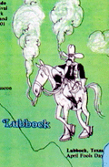 | Details | Anonymous | 1978 |
| Map of the 1978 Marijuana Trail |
|
Anonymous |
|
| 1978 |
| LOC:87 |
| $0.00 | Anonymous | Map-of-the-1978-Marijuana-Trail | SOLD<br></br>Scarce Hippie / Yippie cannabis-related map or a 70's Hippie poster with cartographic interest. An uncommon original pictorial map from 1976 showing gatherings "The Marijuana Trail" planned across the continental United States during the Spring and Summer of 1978.
<br></br>
Interesting iconography used that adapts existing regional stereotypes to a counter-culture cannabis-infused outlook:
<div class="indenttextblocksingle">
<ul style="list-style-type: circle;">
<li>San Francisco- A drunk, be-wigged barrister and a bell-bottom mod smoker.</li>
<li>Ashland, Oregon- Bigfoot getting high</li>
<li>Grand Junction, Colo. Naked hippies with smokie the bear.</li>
<li>Atlanta- Southern gentleman and a banjo-playing hillbilly.</li>
<li>Montreal - a frog, cow, and lumberjack- all smoking</li>
</ul>
</div>
Near Kent, Ohio three citizens are shown holding large signs: REMEMBER | KENT | STATE
<br></br>
For many of the gatherings the provided activity and schedule information could have made this map a fine planning calendar. From A Yipster Times publication. |
| 6430 |  | Details | Anonymous | 1986 |
| Decorative silk-screen poster San Francisco Bay Golden Gate Bridge |
|
Anonymous |
|
| 1986 |
| LOC: |
| $0.00 | Anonymous | Decorative-silk-screen-poster-San-Francisco-Bay-Golden-Gate-Bridge | SOLD<br><br>
Fine decorative nautical-themed limited-edition serigraph poster of San Francisco Bay and the Golden Gate Bridge from the seventh-annual users conference held by Data Design Associates in 1986. Deep rich colors. Signed within (illegible). Number ??? of 600 copies.
<br><br>
Data Design Associates, Inc., was a Sunnyvale, Calif-based developer of mainframe financial software. |
| 6480 |  | Details | Anonymous | 1986 |
| Decorative serigraph poster San Francisco Bay Golden Gate Bridge |
|
Anonymous |
|
| 1986 |
| LOC:1404 |
| $875.00 | Anonymous | Decorative-serigraph-poster-San-Francisco-Bay-Golden-Gate-Bridge | Fine decorative nautical-themed limited-edition silk-screen poster of San Francisco Bay, California and the Golden Gate Bridge from the seventh-annual users conference held by Data Design Associates in 1986. Deep rich colors. Signed within (illegible, maybe Bob Williams ?). Number 127 of 600 copies.
<br><br>
Data Design Associates, Inc., was a Sunnyvale, Calif-based developer of mainframe financial software. |
| 6481 |  | Details | Anonymous | 1986 |
| Decorative serigraph poster City of San Francisco Ferry |
|
Anonymous |
|
| 1986 |
| LOC:1404 |
| $475.00 | Anonymous | Decorative-serigraph-poster-City-of-San-Francisco-Ferry | Fine decorative nautical-themed limited-edition silk-screen poster of San Francisco Bay, California and the ferry "City of San Francisco" from the eighth-annual users conference held by Data Design Associates in 1987. Deep rich colors. Signed within (illegible). Number 579 of 700 copies.
<br><br>
Data Design Associates, Inc., was a Sunnyvale, Calif-based developer of mainframe financial software. |
| 6482 |  | Details | Anonymous | 1986 |
| Decorative serigraph poster San Francisco Bay and Coit Tower |
|
Anonymous |
|
| 1986 |
| LOC:1404 |
| $375.00 | Anonymous | Decorative-serigraph-poster-San-Francisco-Bay-and-Coit-Tower | Fine decorative nautical-themed limited-edition silk-screen poster of San Francisco Bay, California and Coit Tower from the fifth-annual users conference held by Data Design Associates in 1984. Deep rich colors. Signed within (illegible). Number 472 of 500.
<br><br>
Data Design Associates, Inc., was a Sunnyvale, Calif-based developer of mainframe financial software. |
| 6501 |  | Details | Anonymous | 2000 |
| Poster and map for Dean Markley Guitar Strings and Jaros Custom Guitars |
|
Anonymous |
|
| 2000 |
| LOC:78 |
| $150.00 | Anonymous | Poster-and-map-for-Dean-Markley-Guitar-Strings-and-Jaros-Custom-Guitars | Unrecorded poster related to a coast-to-coast tour by Jon Butcher and Bruce Gatewood promoting Dean Markley guitar strings and Jaros Custom Guitars ca. 2000. With an inset map of the tour across the United States including photos of Jon and Bruce.
<br><br>
Jaros Guitars was started by the father and son team of Harry and Jim Jaros of Mary Street, Rochester, Pennsylvania in 1996. Dean Markley has produced guitar strings since 1972.
<br><br>
An archived web page about Jaros Custom Guitars from 1999 tells the Jaros story:
<div class="indenttextblocksingle">
"The Jaros Guitar "factory" is a home-based, part-time operation located in the beautiful Pennsylvania countryside. Jim, his wife Patty, and their sons Jason (14), and Taylor (8), live only 100 yards from Jim's folks, Harry and Mary (and coincidentally, Harry's large well-equipped woodshop).The shop is a 30' x 40' pole-barn with 12' ceilings and three work bays." <br> (Dynamic Duo: This father-son team's a good combination. TradeSecrets. Vol. 25. Wayback Machine)
</div> |
| 8078 |  | Details | Anonymous | 2002 |
| Map of Locations of UFO Sightings in Southwest USA |
|
Anonymous |
|
| 2002 |
| LOC: |
| $0.00 | Anonymous | Map-of-Locations-of-UFO-Sightings-in-Southwest-USA | SOLD<br><br>A boldly graphic, unrecorded, early 21st century persuasive popular culture map titled Map of Locations of UFO Sightings, presenting reported unidentified flying object activity across the southwestern United States. The composition centers on a stylized regional map of the Southwest United States marked with prominent red X symbols indicating areas of concentrated sightings, accompanied by dramatic illustrations of flying saucers, extraterrestrial figures, and cosmic imagery. Prominent geographic references include California, Nevada, Arizona, Utah, Colorado, and New Mexico, with special emphasis on Roswell, reinforcing the enduring mythology surrounding alleged crash sites and government secrecy.<br><br>
Supplementary text panels frame this small map with sensational claims, eyewitness accounts, and references to U.S. Air Force investigations from 1947 to 1996, blending selective historical facts with speculative narrative. Additional vignettes along the lower margin document specific reported sightings from 2002 in California, Florida, Wisconsin, and New York, grounding the imagery in contemporary anecdote. Overall, the piece functions less as a scientific record than as a vivid artifact of modern UFO folklore, Cold War anxiety, and mass-media driven belief, reflecting how cartographic form is used to lend authority and visual coherence to conspiracy culture. |